Osmapy
Jump to navigation
Jump to search
| Osmapy | ||||||||||||||||||||||||||||||||||||||||||||||||||||||||||||||
|---|---|---|---|---|---|---|---|---|---|---|---|---|---|---|---|---|---|---|---|---|---|---|---|---|---|---|---|---|---|---|---|---|---|---|---|---|---|---|---|---|---|---|---|---|---|---|---|---|---|---|---|---|---|---|---|---|---|---|---|---|---|---|
| Author: | Philipp Rigoll and other contributors. | |||||||||||||||||||||||||||||||||||||||||||||||||||||||||||||
| License: | GNU GPL v3 | |||||||||||||||||||||||||||||||||||||||||||||||||||||||||||||
| Platforms: | Windows, Linux, and macOS | |||||||||||||||||||||||||||||||||||||||||||||||||||||||||||||
| Version: | 0.0.18 (2020-06-21) | |||||||||||||||||||||||||||||||||||||||||||||||||||||||||||||
| Language: | English
| |||||||||||||||||||||||||||||||||||||||||||||||||||||||||||||
| Website: | https://github.com/PhilippRigoll/osmapy | |||||||||||||||||||||||||||||||||||||||||||||||||||||||||||||
| Source code: | https://github.com/PhilippRigoll/osmapy | |||||||||||||||||||||||||||||||||||||||||||||||||||||||||||||
| Programming language: | Python | |||||||||||||||||||||||||||||||||||||||||||||||||||||||||||||
| ||||||||||||||||||||||||||||||||||||||||||||||||||||||||||||||
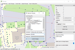
Osmapy is an OpenStreetMap editor programmed in Python. Python is modern, has a huge user base and is battery-included. This allows everyone to contribute to this project. Osmapy uses the widespread, powerful and freshly-looking Qt-framework. Windows, MacOS and Linux is supported. Currently Osmapy is more like a proof of concept than a full fledged editor. But it can already be used to modify OSM nodes, tags, geometry and upload it to Openstreetmap.
Features
The following Features are already implemented:
- Interface to Slippy Tiles
- LiFo queue to load the most needed tiles first
- Multiple workers to download tiles
- Caching
- Easy configuration to chose tile servers
- Layers
- Multi-Layer support
- Change layer order by Drag'n'Drop
- Change the opacity of layers
- GPX files
- GPX files are easily loaded by Drag'n'Drop
- OSM objects modification
- Create / Modify / Delete OSM nodes
- Add / Change / Remove Tags
- Precise node moving with the arrow keys
- Upload your changes to the OSM server
- Adaptive appearance
- All the tool windows can be moved around freely
- Easy configuration
- Just one YAML file must be modified
Contributing
The code is managed via GitHub https://github.com/PhilippRigoll/osmapy. All contributions are welcome!

