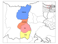
Project Taplejung
| V・T・E |
| latitude: 27.6111, longitude: 87.8233 |
| Browse map of Taplejung District 27°36′39.96″ N, 87°49′23.88″ E |
| Edit map |

|
|
| External links: |
| Use this template for your locality |
Taplejung District is a district in Mechi Zone, Eastern Development Region, Nepal at latitude 27°36′39.96″ North, longitude 87°49′23.88″ East.
4589478![]() 4589478
4589478
Description
Project goals
Mapping on the project have following (and more) goals:
1. To get the utmost possible data accuracy using high resolution imagery from Bing and Digital Globe in area.
2. To provide up to date maps in the cases of Disasters
3. Show public bodies how OSM and satellite images will be useful to provide maps with higher spatial resolution for Large Geographic Area
4. To update the spatial database for public use .
5. To develop this project as a example project for other developing nations.
Techniques
Mappers from Western countries (people who are remotely mapping) on the project should focus on the geometry development (Point, Line, Polygon) with highest possible spatial accuracy.
People nearby or at Nepal (Local People) should Name the features and add other important attributes (tags) of the spatial data.
Progress of geometry data as well as attribute information should be updated together. The collaboration of International mappers and local people makes the complete map because only geometry or the only text can never give complete information.
We can use following tools to map on this project for the fast editing of the data.
JOSM
Imaginary preferences
- Bing
- DigitalGlobe Premium Imagery
- Mapbox
Plugings
iD
Some users may also use iD editor to contribute their work.
All the Technical information about mapping, specification, tags, relationships can be found at Project Ilam Specification page
Project area
Participants
Contributors for this project are/Could be:
- Kathmandu Living Labs
- OSMStats Nepal
- Different University Student associations like GESAN (Geomatics Engineering Students' Association of Nepal)
- YouthMappers
- Department of Survey Nepal
See also
- Project Ilam specification
- List of zones of Nepal
- List of districts of Nepal
- List of provinces of Nepal
Possible Scientific Application
Map has always been the Source of determination of pattern for analysis of BIG data, Beside Humanitarian use map from this project may also be useful for the research purpose for different data and scientific veterans. Some of possible application are:
- Analysis of Deforestation
- Analysis of Spatial Pattern for analysis and management of social conflict and problems.
- Analysis of pattern of urbanization and economic Growth.
- planning of development projects.
