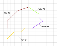
Relation:multilinestring
| Description |
|---|
| A discontiguous series of unclosed ways that semantically represents a single physical object. |
| Group: properties |
| Members |
|
|
| Status: in use |
| Tools for this tag |
|
A relation tagged type=multilinestring is a discontiguous series of unclosed ways that semantically represents a single physical object.
Rationale
This relation type is named by analogy with multipolygon relations. The term "MultiLineString" comes from the Simple Features specification, an ISO/OGC standard, which also defines the terms "MultiPolygon" and "LineString". The type=multilinestring tag has been included in two separate proposals, Proposed features/Multilinestring and Relations/Proposed/boundary segment.
When to use
This relation type is used when a single physical object would qualify as a multipolygon, except that it covers no area because it consists of linear features (unclosed ways). For example, some mappers use multilinestring relations when micromapping geoglyphs (man_made=geoglyph) that resemble written text.
Do not use this relation type for a collection of independent linear features just because they are thematically related, because relations are not categories.
Tags to use in combination
- inscription=* for the text that the multilinestring spells out
Members
The overwhelming majority of uses of this relation type have members with empty roles.
See also
- Relation:multipolygon - analogous representation for MultiPolygons
- Relation:route - like multilinestring but contiguous, forming a route that can be followed from end to end
- Relation:site - a more general-purpose relation type for all the features that form a single site, regardless of geometry type
- Relation:collection - a more general-purpose relation type that violates the relations are not categories principle
