Render MyMap
Jump to navigation
Jump to search
| render(myMap) | ||||||||||||||||||||
|---|---|---|---|---|---|---|---|---|---|---|---|---|---|---|---|---|---|---|---|---|
| Author: | Ferenc Veres (Kempelen (talk)) | |||||||||||||||||||
| License: | GNU GPL v3 | |||||||||||||||||||
| Platform: | Linux | |||||||||||||||||||
| Version: | (2021-07-14) | |||||||||||||||||||
| Language: | English
| |||||||||||||||||||
| Website: | http://render.osmtippek.hu/ | |||||||||||||||||||
| Source code: | https://sourceforge.net/p/render-mymap/ | |||||||||||||||||||
| Programming language: | PHP | |||||||||||||||||||
|
Render small area printable maps for local detail survey |
||||||||||||||||||||
| ||||||||||||||||||||
About
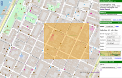
render(myMap) provides easy way to render specially styled OpenStreetMap maps, for surveying the area. We call it detail survey print, where all objects are rendered.
It consists of a web frontend and a server backend that uses an external OSM render engine to generate maps. No PostGIS or other complex OSM backend required. The system has been in development and use since 2011. See built in help on the live website (demo) for more info on usage.
Features of the web frontend
- Browse the map using default OpenStreetMap style
- Search for places using Nominatim
- Select a box that you want to print
- Choose page options: A4, Letter, 1 page, 2x1, 2x2, ..., 3x3 pages
- Choose from 3 styles
- POIs
- House numbers
- Wheelchair accessibility
- Choose from 3 detail levels
- Full detail
- Medium detail
- Bare
- Browse and view previous renders
Features of the backend
- Listens for jobs coming from the frontend and responds immediately using incrond
- Downloads live OSM data from OverPass servers
- Renders OSM data into a map using Ceyx
- Generates a printer friendly HTML page
Features of the render
- Uses Ceyx to render map
- Rendering is configured in mapcss files
- The default styles are optimized for printing everything that appears in the database
- All ways, all nodes will appear on the print (in Full Details mode)
- Objects with name will get the name as label (or alternative names, like operator)
- Objects with no name will get a well identifiable label like "fire_hydrant" (most items also got icons, but far from all)
Limitations
- Due to limited capabilities of the demo server, there are limits to the area you can print here But should be satisfying to most in-depth surveys!
- Area selection is not enforcing aspect ratio of the selected paper: so it's your turn to choose area that fits your work (e.g. I prefer to leave 1/4 space on the paper for writing there) (It's a feature, not a bug.)
See also
- http://render.osmtippek.hu - Online demo
- https://sourceforge.net/p/render-mymap/ - SourceForge project page
