Switzerland/HikingNetwork
Hiking paths and hiking routes
The cantonal organisations of Swiss Hiking are running a network of more than 60,000km of hiking paths. In the framework of SwitzerlandMobility they are running the project Hiking in Switzerland with a multitude of national, regional and local hiking routes within their network. Additionally, there a various regional and local hiking routes from other organisations.
Hiking routes
Hiking in Switzerland
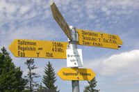
Hiking in Switzerland describes 6 national routes (No. 1-6), 57 regional routes (No 22-99), and 143 local routes. The national and regional routes are tagged with a green square beside the yellow guidepost. This square contains the number and the name of the route.
Other routes
Additionally, there are many regional routes (e.g. Tour des Muverans) and local routes (e.g. Sentiers des Narcisses or On the Tracks of the Fox) that are run by various organisations.
Recommended tagging
The routes should be described with relations.
| Tag | Description |
|---|---|
| type=route | |
| route=hiking | This is a hiking route. |
| name=* | official name of the route (for example: "Via Alpina") |
| ref=* | Number of the route, as written on the guidepost (without nwn/rwn classification) |
| network=nwn/rwn | Type of the route. nwn for national routes, rwn for regional routes |
| symbol=* | description of the way marker, preferably in the local language, e.g. weisse 47 auf grünem Rechteck (white 47 on green rectangle) |
| osmc:symbol=* | machine-readable description |
| operator=Wanderland Schweiz | official operator |
Status
See the separate status page.
Hiking path network
The following section is a proposal. Comments are welcome
The hiking network in Switzerland allows nearly any place to be reached by foot. The paths are usually maintained by the cantonal organisations of Swiss Hiking. The paths are classified by three levels of difficulties: Hiking paths (yellow markers), mountain paths (white-red-white markers) and alpine paths (white-blue-white markers).
Recommended tagging
The hiking network is different from common hiking routes: Each segment or edge of the network is anonymous, has no name or reference for itself. The nodes of the network are the junctions, where you will find a guide post with directions to decide which path you need to take. Tagging works if just those lines between the nodes are added to a route relation. It is sufficient if a way appears once in a hiking path network relation (netwrok=lwn). Each relation is linear. This can be just the route between two junctions, but it can also be extended across a few junctions, if it remains linear, such that you don't need to create too many tiny relations.
| While it is sufficient to have a each way in a single relation, some mappers prefer route relations with start and end at named guide posts or other places where a distinct name can be found for a unique junction. This leads to multiple relations for a single way when not every junction is named. Map however you like, but be tolerant of each other. |
Guideposts
Along the hiking routes you can find guideposts. Some of those guideposts have a small white signboard with the name of the place (usually open fields names) and the elevation over mean sea level. They should be tagged as described on tag:information=guidepost.
| Tag | Description |
|---|---|
| tourism=information | Tourist information |
| information=guidepost | a guidepost |
| name=* | Name from guidepost label, for example:name=Breitenau
|
| ele=* | If available, elevation over mean sea level, for example:ele=1250
|
| hiking=yes | Define hiking guidepost |
| image=* | Photo of guidepost: for more details such as hiking duration, direction,
e.g:
Use a suitable category on Wikimedia Commons, e.g.:
|
For mapping the destinations seen on the guidepost, you can get some inspiration from Relation:destination_sign or the simpler Key:direction_north using the compass directions.
Routes
A way between two junctions in the network is tagged as a usual hiking relation with network=lwn.
| Tag | Required? | Description |
|---|---|---|
| type=route | required | |
| route=hiking | required | This is a hiking route |
| network=lwn | required | local hiking network |
| osmc:symbol=* | required | machine-readable description of the way marker: yellow::yellow_diamond (hiking path), red:white:red_bar(mountain path), blue:white:blue_bar(alpine path) |
| symbol=* | optional | free-text description of way marker, preferably in the local language |
| operator=* | optional | official operator, if known. Example: "Verein Berner Wanderwege" |
| from=* | optional | Start place of this relation. This is mainly for the mappers and helps with maintenance, if relations break. Name of named guide post if it starts at a named one. |
| to=* | optional | End place of this relation. This is mainly for the mappers and helps with maintenance, if relations break. Name of named guide post if it ends at a named one. |
| note=begin-end | optional | Previously used alternative to from=* and to=* |
| osmc:name=* | optional | descriptive Name for the OSMC Reit- und Wanderkarte. (Without this tags the route will not be rendered on that site. It is also used for the directory of hiking routes.) |
| name=* | exceptional | official name of the route (for example "Via Alpina")
|
Datasets
Hiking routes are typically included in the GIS platforms of the cantons. Some of these datasets are published as open data.
| Canton | Description | Link |
|---|---|---|
| Thurgau | WMS, respectively WFS, service of hiking routes in the canton of Thurgau published on opendata.swiss | [1] |
Rendering
- The Waymarked Trails: Hiking by user:lonvia shows the Wanderland network as well as the local routes. The map is updated minutely.
- Switzerland is also rendered on the OSMC Reit- und Wanderkarte. Routes without names will only be shown if the osmc:name tag is set.
- The Garmin maps of openmtbmap.org show the hiking routes of Switzerland.
