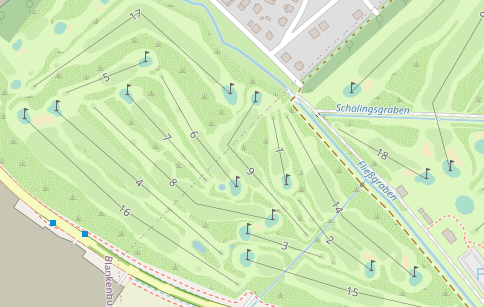
Tag:golf=hole
| Description |
|---|
| The path from tee area to the green |
| Rendering in OSM Carto |

|
| Group: leisure |
| Used on these elements |
| Useful combination |
| Status: de facto |
| Tools for this tag |
|
The hole is represented by a way along the standard playing path from tee area to the green.
How to map
Draw a way ![]() from the tee to the pin and add golf=hole.
from the tee to the pin and add golf=hole.
You can add
- ref=* - number of the hole
- par=* - number of strokes normally required for this hole
- dist=* - the distance of the hole
- handicap=* - difficulty ranking of a hole in a golf course from 1 to 18, used to determine the allocation of handicap shots
- name=* - (rare) the common name of the hole, if there is one. Hole number belongs to ref=*
Unless a golf hole has an actual name, use ref=*
For example, the Masters Golf Course in Augusta, Georgia, USA, not only assigns numbers to their golf holes, but specific names are assigned to each one;
Hole 1 – Tea Olive, Hole 2 – Pink Dogwood, etc.
In this case, both ref=* and name=* would be tagged on the golf hole. The tag ref=* would be used to describe hole numbers while the tag name=* would be used for the name of each hole.
If a hole does not have an actual name, ref=* is sufficient.
If values (par, handicap, dist) differ for different colour references, subkeys are in use, e.g.: par:red=* or handicap:blue=*.
Example
See also
- leisure=golf_course - A golf course

