Tag:protected_area=conservation
 |
| Description |
|---|
| A large undeveloped area used predominantely for conserving natural resources |
| Group: boundaries |
| Used on these elements |
| Useful combination |
| Status: in use |
| Tools for this tag |
|
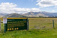
The tag protected_area=conservation is used to tag areas that are primarily designated for the broad purpose of plant and wildlife conservation, biodiversity, and natural resource protection. These areas are preserved in their natural state and are not primarily intended for public recreation. While they may allow public access, fishing, hunting, or other human usages, their main function is environmental protection and conservation. Such areas may include habitats critical for endangered species and ecosystems requiring preservation. State Conservation Areas in various countries can be categorized under this tag. This tag should often be coupled with leisure=nature_reserve to indicate the focus on nature conservation.
Consider the following tagging for these areas:
boundary=protected_area
|
Indicates that the area is a protected area |
|---|---|
protected_area=conservation
|
Indicates that the area is predominately used for recreation |
protect_class=1a,1b,2-6
|
Indicates that the area is can be categorized with an IUCN protection category |
name=*
|
The area's name |
protection_title=*
|
The title of the area, for example, Conservation Management Area.
|
operator=*
|
The government agency or private entity that operates the amenities in the park |
See also
For similar open space lands, see the following:
- For smaller manicured parks, see
leisure=park - For nature reserves, see
leisure=nature_reserve - For recreation areas, see
boundary=protected_area+protected_area=recreation - For historic areas, see
historic=*orheritage=*