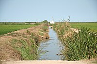
Tag:service=irrigation
Jump to navigation
Jump to search
| Description |
|---|
| Specifies a waterway which carries water to be used for agriculture |
| Group: waterways |
| Used on these elements |
| Requires |
|
| Useful combination |
| See also |
| Status: in use |
| Tools for this tag |
|
Artificial waterways which bring water to agriculture fields or facilities are sometimes tagged with service=irrigation
Alternative tagging
- irrigation=yes was the first tag used, starting it 2011. As of May 2019, it has been used 200 times with canals and 2000 times with ditches. Most of these tags were added between 2011 and 2013.
- service=irrigation was used starting in 2012, as as of May 2019 is used 12,000 times,
- usage=irrigation was introduced in 2018 and usage is increasing quickly. As of early June 2021, is currently used 18,000 times.
- About 200 canals are tagged canal=irrigation

