Toronto Mapping Weekend
An event to get together and map Toronto
Second Toronto Mapping Weekend
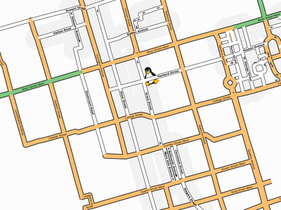
The next Toronto Mapping Weekend will be held from Friday 30 Nov., 2007 to Sunday 02 Dec., 2007 and will be based again at the GNU/LinuxCaffe 326 Harbord Street, Toronto, ON, Canada, M6G 1H1 (416) 534-2116.
What is a mapping weekend?
From the Mapping_Weekend_Howto.
Okay, I sort of get it, I'm in Toronto. Why should I care?
You can use OSM data to create maps that are important to you.
- Do you want to show your clients how to get to your business?
- Do you live in a new neighbourhood that isn't shown on internet maps?
- Do you want to share that amazing hiking trail with your friends and family?
- Do you wonder how well you did climbing that huge hill on your bicycle?
- Do you want to know exactly how far and how fast you run each week?
- Where did you catch that big fish?
- Do you want to plan a "Pub Crawl" with the maximum number of establishments and minimum total distance?
Venue
Our base of operations will be The GNU/Linuxcaffe on Harbord Street. So we'll have the two key ingredients for mapping available to us; fast wireless and delicious hot chocolate. Linuxcaffe will also have their full, delicious menu for sale to attendees. They are a cafe, after all.
Introduction to OSM
The Intro to OSM presentation will cover the basics of OpenStreetMap as well as how to collect data for the Toronto OSM Mapping Weekend. It is suitable for those new to OSM and all with an interest any of the following topics GPS, mapping, GIS, Free / Libre Open Source Software, Toronto neighbourhoods or Pirates.
Mapping
Friday night we'll have an introduction to OSM presentation and discussion at LinuxCaffe. If you are curious about OSM and want to find out more, this is the place to be. You'll be all set to start mapping with the rest of us on Saturday morning. We'll also organize "who will map where?" so that we don't needlessly duplicate our efforts.
We'll go mapping Saturday and Sunday divided roughly into morning and afternoon sessions. There will be a second intro to OSM presentation on Saturday at 11:00 am for those who are interested. Even those late-starters will be able to participate in some of the mapping.
Saturday night we'll meet for dinner and discussion at LinuxCaffe, and to edit combine and upload our maps. And to build the required collective mapping party video. Much fun will be had by all.
Mapping will continue on Sunday and we'll wrap up Sunday night either at LinuxCaffe or by email as determined by folks on Saturday.
We can map on foot, bicycle, roller skates or automobile, weather permitting. So much of Toronto has yet to be mapped that most anything that catches the interest of a participant will be a worthwhile addition to OpenStreetMap. Want to map the area you grew up in? Do it. Fancy adding the Martin Goodman bicycle trail? Do it. A large portion of Scarborough? Fantastic. Have an urge to mark all of the best nightclubs? Super.
Mapping plan
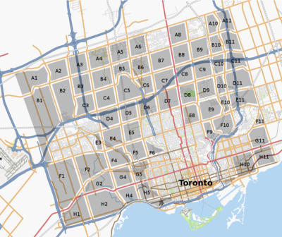
The Toronto map has improved through the summer of 2007 and the arterial roads are substantially complete for Toronto, North York, Scarborough and Etobicoke. Let's fill in some of the neighbourhoods defined by those arterial roads.
Each "square" takes from two to four hours to map by car, depending on weather, experience, familiarity. Plan a few different squares for your morning and afternoon mapping and let us know in advance so that we can avoid duplication. We'll meet Saturday night at LinuxCaffe for a social, to edit and upload and to plan for Sunday.
Let's see if we can fill in more of the old city boundaries, (Steeles Avenue in the north, Victoria Park Avenue on the east, Highway 427 and highway 27 on the west) before we venture further afield.
Who will do what?
Do you plan to attend? List yourself here. Indicate the sections you plan to map on Saturday morning and afternoon, so that we don't duplicate efforts. We'll all meet Saturday evening to discuss Sunday plans.
- RW - I'll start with A8 and B8 on Saturday, with C8 as a backup if things go quickly.
- Michael Mather - I'll give an introduction to mapping on Friday Evening. I'll probably start with H10 on Saturday.
- Ian - plans to tackle A1 and A2 as time permits on this double-booked weekend.
- Henry - Thinking about F9 as a first mapping effort
- RD - plans to map the Beltway trail on bicycle, so I hope the snow holds off.
- Historybuff - I've got A5 and A6 mapped (except I'm not sure how to mark parks, which makes A6 a bit more bare). I've also done significant parts of B6 C6 D6 and D7, as well as F6. Some of this needs uploading still.
- edit the page to add yourself here.
Meeting notes
Friday Night - Michael's presentation Friday night was well prepared and warmly received. We had several new and curious mappers join us for the intro presentation. And the hot chocolate was unmatched. It was great to get together with three other experienced mappers and compare notes. The enthusiasm of the new mappers is infectious too. We set our survey plans for Saturday and will meet up at dinner time at LinuxCaffe for editing and more conversation. Rw 04:55, 1 December 2007 (UTC)
Saturday - Several of us met at LinuxCaffe for Ian's intro presentation for new mappers. We had great weather for mapping, clear and brisk all day. Historybuff introduced himself and we took off mapping. Saturday evening, two of us met back at LinuxCaffe for editing. A new editor had trouble with the API and was not able to confirm his account. Rw 13:25, 2 December 2007 (UTC)
Sunday Morning - Well look at that. I have magical powers. Two mapping weekends; two snow days. We have a Winter Storm Warning this morning, so all mapping if OFF today. Stay off the roads and warm. See you in the Spring. Rw 13:25, 2 December 2007 (UTC)
Getting there
by air
Pearson (Toronto) International Airport serves Toronto. Taxi or Limousine service from the airport to downtown can be pre-arranged or ad-hoc.
by car
Linuxcaffe is at the corner of Harbord Street and Grace Street.
by public transportation
Linuxcaffe is one block south of Christie subway station on Grace Street.
GPS coordinates
43.660095, -79.417436
What to bring?
Are you coming to find out what OSM is all about? Bring:
- your curiosity.
Are you already fascinated by OSM, and looking to share tips with other mappers? Want to join us in mapping more of Toronto? Bring:
- This is a winter event. Dress appropriately.
- your GPS, memory card, extra batteries / charger
- your camera, memory card, extra batteries / charger
- notepad, pen / pencil for notes while mapping
- your laptop for OSM editing on-site
History
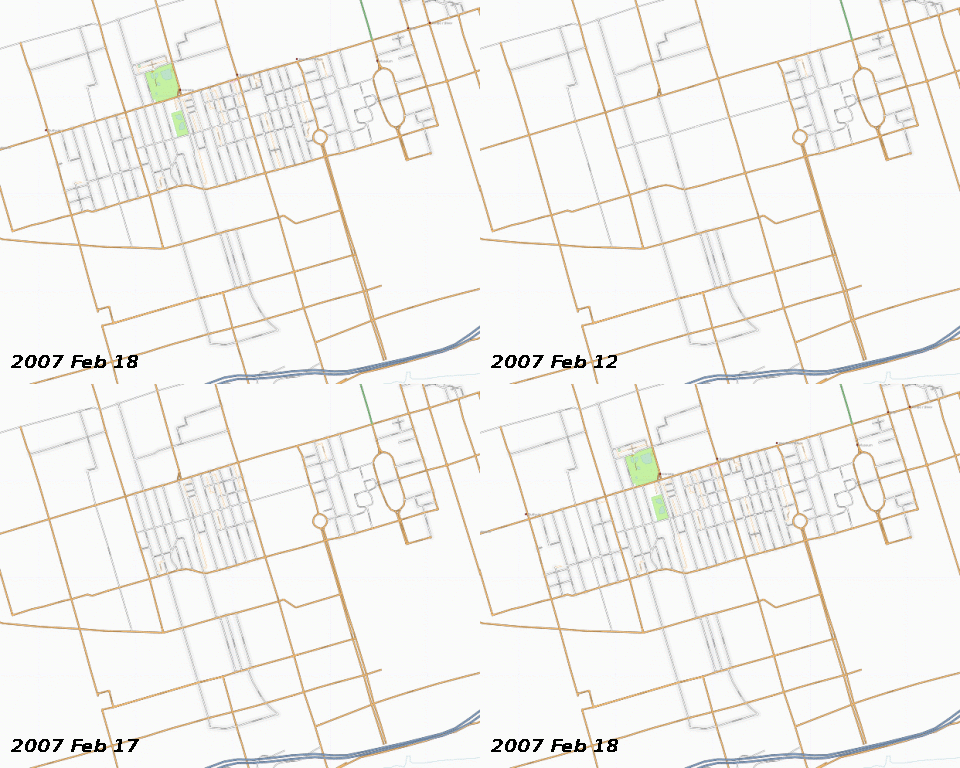
The first Toronto Mapping Weekend was held on February 17 - 18, 2007.
First Toronto Mapping Weekend results
What is OpenStreetMap?
OpenStreetMap is the wiki-style map of everything. It is a collection of tools that are free for anybody to use, that create maps that are free for anybody to use.
Location
Toronto is a city of two and a half million inhabitants on the Canadian side of Lake Ontario in North America. It is a major center in Canadian business, transportation, communication, film and television. And we are going to map it. Join us.
Who's attended?
We had a small but enthusiastic group for our first mapping party in February 2007. Some mapping was done on Saturday and Sunday, including a new OSM contributor who mapped some parks on foot in the snow.


