UK TravelOptions
If you know about the current state of affairs, please help keep everyone informed by updating this information. (Discussion)
| UK TravelOptions | ||||||||||||||||||||||||||||||||||||||||||||||||||||||||||||||||||||||||||||||||||||||||||||||||||||||||
|---|---|---|---|---|---|---|---|---|---|---|---|---|---|---|---|---|---|---|---|---|---|---|---|---|---|---|---|---|---|---|---|---|---|---|---|---|---|---|---|---|---|---|---|---|---|---|---|---|---|---|---|---|---|---|---|---|---|---|---|---|---|---|---|---|---|---|---|---|---|---|---|---|---|---|---|---|---|---|---|---|---|---|---|---|---|---|---|---|---|---|---|---|---|---|---|---|---|---|---|---|---|---|---|---|
| Author: | fasterimaging.com & placr.co.uk | |||||||||||||||||||||||||||||||||||||||||||||||||||||||||||||||||||||||||||||||||||||||||||||||||||||||
| License: | Proprietary (free of charge) | |||||||||||||||||||||||||||||||||||||||||||||||||||||||||||||||||||||||||||||||||||||||||||||||||||||||
| Platforms: | iPhone and iPad | |||||||||||||||||||||||||||||||||||||||||||||||||||||||||||||||||||||||||||||||||||||||||||||||||||||||
| Status: | Broken | |||||||||||||||||||||||||||||||||||||||||||||||||||||||||||||||||||||||||||||||||||||||||||||||||||||||
| Version: | 1.33 (2014-10-13) | |||||||||||||||||||||||||||||||||||||||||||||||||||||||||||||||||||||||||||||||||||||||||||||||||||||||
| Language: | English
| |||||||||||||||||||||||||||||||||||||||||||||||||||||||||||||||||||||||||||||||||||||||||||||||||||||||
| Website: | http://uktraveloptions.com/ | |||||||||||||||||||||||||||||||||||||||||||||||||||||||||||||||||||||||||||||||||||||||||||||||||||||||
|
Vector map viewing with tilting/spinning 3D buildings & transport data of London. |
||||||||||||||||||||||||||||||||||||||||||||||||||||||||||||||||||||||||||||||||||||||||||||||||||||||||
| ||||||||||||||||||||||||||||||||||||||||||||||||||||||||||||||||||||||||||||||||||||||||||||||||||||||||
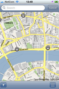
UK TravelOptions is an app for the iPhone and iPad. It displays OpenStreetMap maps of the UK & Ireland, with very nice client-side vector rendering, which displays normal looking maps, but then allows a seamless tilt into a 3D display. Spinning the view angle, raising and lowering building heights is possible using various finger gestures.
The rendering engine is technology from fasterimaging, which is highly optimised for low data transfer, making for a fluid zooming/panning experience.

|

|
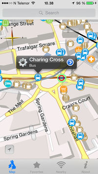
The app also presents certain classifications of POIs from OpenStreetMap. These are click-able, taking you to some more information taken from selected OSM tags. Display of the different types can be switched on and off.
placr.co.uk supply transport intelligence data, currently for London. The most interesting displays relate to tube performance, (click the tube stations), but all the bus stops now also take you to bus timetable displays. Likewise for ferry terminals, and Croydon tramlink stops. They have plans to expand this to offer data for other transport networks. There may be some more OSM stuff brought into that mix.
