User:Berse/villa
Jump to navigation
Jump to search
| Descrizione |
|---|
| Ampia residenza collegata ad attività agricola, storicamente destinata alle classi sociali più elevate. |
| Rappresentazione in OSM Carto |

|
| Gruppo: Edifici |
| Applicabile agli elementi |
| Combinazioni utili |
|
| Stato: non specificato |
| Strumenti |
Definition
Use building=roof for roofs which are open at least at two sides.
How to map
If there are already other features below the roof on the map, consider adding layer=1 (or another appropriate layer tag) to the roof.
Examples
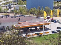
This tag is for instance used for the roofs of petrol stations (amenity=fuel).
edita qui: http://wiki.openstreetmap.org/w/index.php?title=IT:Tag:building%3Dvilla&action=edit&redlink=1
