User:Onion/Mapper
Mapper
| Mapper | ||||||||||||||||||||||||||||||||||||||||||||||||||||||||||||||||||||||||||||||||||||||||||||||||||||||||
|---|---|---|---|---|---|---|---|---|---|---|---|---|---|---|---|---|---|---|---|---|---|---|---|---|---|---|---|---|---|---|---|---|---|---|---|---|---|---|---|---|---|---|---|---|---|---|---|---|---|---|---|---|---|---|---|---|---|---|---|---|---|---|---|---|---|---|---|---|---|---|---|---|---|---|---|---|---|---|---|---|---|---|---|---|---|---|---|---|---|---|---|---|---|---|---|---|---|---|---|---|---|---|---|---|
| Author: | user:Onion | |||||||||||||||||||||||||||||||||||||||||||||||||||||||||||||||||||||||||||||||||||||||||||||||||||||||
| License: | GNU GPL | |||||||||||||||||||||||||||||||||||||||||||||||||||||||||||||||||||||||||||||||||||||||||||||||||||||||
| Platforms: | Maemo, n800, and Linux | |||||||||||||||||||||||||||||||||||||||||||||||||||||||||||||||||||||||||||||||||||||||||||||||||||||||
| Version: | 1.0.6.8 (2010-06-30) | |||||||||||||||||||||||||||||||||||||||||||||||||||||||||||||||||||||||||||||||||||||||||||||||||||||||
| Language: | English
| |||||||||||||||||||||||||||||||||||||||||||||||||||||||||||||||||||||||||||||||||||||||||||||||||||||||
| Website: | http://mapper.tal.org/ | |||||||||||||||||||||||||||||||||||||||||||||||||||||||||||||||||||||||||||||||||||||||||||||||||||||||
| Source code: | http://git.tal.org/cgi-bin/gitweb.cgi?p=mapper.git;a=summary | |||||||||||||||||||||||||||||||||||||||||||||||||||||||||||||||||||||||||||||||||||||||||||||||||||||||
|
A Maemo Mapper fork |
||||||||||||||||||||||||||||||||||||||||||||||||||||||||||||||||||||||||||||||||||||||||||||||||||||||||
| ||||||||||||||||||||||||||||||||||||||||||||||||||||||||||||||||||||||||||||||||||||||||||||||||||||||||
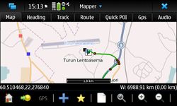
Mapper is a geographical mapping tool, that can be used to view maps, displaying your position with a GPS device, handle POIs, use OpenStreetMap data for geo information and can create and export GPX tracks. It runs on handhled devices like the Nokia Internet Tablets (770, N800 and N810) as well as on normal Linux desktops.
It downloads maps from map sites (OSM) and caches them localy. Maps can be panned and zoomed. With the help of a GPS devices it can be used for manual navigation (routing is coming soonish), with heading and course indicators. Street and POI information can be imported from OpenStreetMap planet files. With the help of this data the user can search for street and POIs. POIs are also displayed on the map. Also the current locations street name and place is displayed.
For more information see the home page or sources:
- Mapper home page
- Mapper git repository
- Mapper Garage project page.
Packages
Packages are only available for Internet Tablets. Use the source to build for other systems.
| Version | OS/Tablet | Repository |
|---|---|---|
| 1.0.6.7 | OS2008, Maemo 5 (N8X0, N90) | maemo.org extras-devel |
| 1.0.3.95-rc2 | OS2006 (770) | deb http://ftp.tal.org/pub/maemo gregale free |
