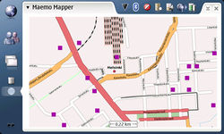
Maemo Mapper
| Maemo Mapper | ||||||||||||||||||||||||||||||||||||||||||||||||||||||||||||||||||||||||||||||||||||||||||||||||||||||||
|---|---|---|---|---|---|---|---|---|---|---|---|---|---|---|---|---|---|---|---|---|---|---|---|---|---|---|---|---|---|---|---|---|---|---|---|---|---|---|---|---|---|---|---|---|---|---|---|---|---|---|---|---|---|---|---|---|---|---|---|---|---|---|---|---|---|---|---|---|---|---|---|---|---|---|---|---|---|---|---|---|---|---|---|---|---|---|---|---|---|---|---|---|---|---|---|---|---|---|---|---|---|---|---|---|
| License: | GNU GPL | |||||||||||||||||||||||||||||||||||||||||||||||||||||||||||||||||||||||||||||||||||||||||||||||||||||||
| Platform: | Maemo | |||||||||||||||||||||||||||||||||||||||||||||||||||||||||||||||||||||||||||||||||||||||||||||||||||||||
| Status: | Unmaintained | |||||||||||||||||||||||||||||||||||||||||||||||||||||||||||||||||||||||||||||||||||||||||||||||||||||||
| Version: | 3.0 (2010-03-15) | |||||||||||||||||||||||||||||||||||||||||||||||||||||||||||||||||||||||||||||||||||||||||||||||||||||||
| Language: | English
| |||||||||||||||||||||||||||||||||||||||||||||||||||||||||||||||||||||||||||||||||||||||||||||||||||||||
| Source code: | https://vcs.maemo.org/git/maemo-mapper | |||||||||||||||||||||||||||||||||||||||||||||||||||||||||||||||||||||||||||||||||||||||||||||||||||||||
| Programming language: | C | |||||||||||||||||||||||||||||||||||||||||||||||||||||||||||||||||||||||||||||||||||||||||||||||||||||||
| ||||||||||||||||||||||||||||||||||||||||||||||||||||||||||||||||||||||||||||||||||||||||||||||||||||||||
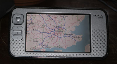
Maemo Mapper is a map application for the Maemo platform, a Linux distribution developed for the Nokia Internet tablets like the N770 or n8x0. More recently Maemo Mapper transformed into Mappero, the information on this page could be considered outdated.
Maemo Mapper might be a "Killer Application", regardless that the devices get shipped with a commercial map application installed. If you want to ride your bike or go hiking, OSM maps paired with Maemo Mapper simply are state of the art.
Overview
OSM map tiles meanwhile are the default map source for Maemo Mapper. You can download tiles for an area or along a route in advance so no Internet connection is needed during the trip.
Maemo Mapper stores all its information, including the map tiles, in an sqlite 3 database file. Additionally, it supports "Routes" with spoken turn by turn directions via flite. This requires a precalculated "route" (which actually is a track :) where some trackpoints have a desc-tag assigned, though. The author of Maemo Mapper provides a service which creates such routes via http://gnuite.com/
Setting up
OSM is the default map repository since Maemo Mapper 1.4.3. If you need to add a tile source manually, use the following URL formats:
- Mapnik: https://tile.openstreetmap.org/%0d/%d/%d.png
- Osmarender: https://tah.openstreetmap.org/Tiles/tile/%0d/%d/%d.png
File Formats
Maemo Mapper can import and export data as GPX, though it seems to be a bit picky: Reading valid gpx data can be difficult (e.g. it doesn't read the waypoints as produced by User:SlowRider). OTOH, the formats it likes look a bit strange. There's nothing wrong with that, but average users should be aware of the fact to avoid frustration :) .
Problems with Waypoint files
When trying to import GPX waypoints as POIs, Maemo Mapper seems to dislike the <metadata> at the beginning of the files and the <extensions> in each waypoint. Hopefully, Maemo Mapper will just ignore them in a future version instead of canceling the import.
Default "Route" Format
You can autocreate a route using http://gnuite.com/. This will give you a *track* in a GPX file. For speech output, the relevant trackpoints contain a <desc> tag:
<?xml version="1.0"?>
<gpx version="1.0" creator="http://www.gnuite.com/cgi-bin/gpx.cgi" xmlns="http://www.topografix.com/GPX/1/0">
  <trk>
    <trkseg>
      <trkpt lat="49.01057" lon="8.39672">
        <desc>Head west on Passagehof toward Akademiestraße. Go 0.1 kilometers.</desc>
      </trkpt>
      <trkpt lat="49.01059" lon="8.39593"/>
      <trkpt lat="49.01067" lon="8.39582"/>
      <trkpt lat="49.01098" lon="8.39565">
        <desc>Turn left at Akademiestraße. Go 0.2 kilometers.</desc>
      </trkpt>
      <trkpt lat="49.0108" lon="8.39502"/>
      <trkpt lat="49.01086" lon="8.39351">
        <desc>Turn right at Douglasstraße. Go 91 meters.</desc>
      </trkpt>
      <trkpt lat="49.01167" lon="8.3936">
        <desc>Turn left at Stephanienstraße. Go 0.5 kilometers.</desc>
      </trkpt>
      <trkpt lat="49.01105" lon="8.39078"/>
      <trkpt lat="49.01055" lon="8.3883"/>
      <trkpt lat="49.01055" lon="8.38745">
        <desc>Turn left at L605/Reinhold-Frank-Stravenueße. Continue to follow L605. Go 0.6 kilometers.</desc>
      </trkpt>
      <trkpt lat="49.00664" lon="8.38705"/>
      <trkpt lat="49.00541" lon="8.38676">
        <desc>Turn left at B10/B10n/Kriegsstraße. Go 0.3 kilometers.</desc>
      </trkpt>
      <trkpt lat="49.00537" lon="8.38929"/>
      <trkpt lat="49.00539" lon="8.39098">
        <desc>Exit onto Kriegsstraße/L561. Continue to follow Kriegsstraße. Go 0.3 kilometers.</desc>
      </trkpt>
      <trkpt lat="49.00532" lon="8.39119"/>
      <trkpt lat="49.00532" lon="8.39472">
        <desc>Turn left at Karlstraße/L561. Continue to follow Karlstraße. Go 68 meters.</desc>
      </trkpt>
      <trkpt lat="49.00593" lon="8.39469">
        <desc>Turn right at Herrenstraße. Go 0.4 kilometers.</desc>
      </trkpt>
      <trkpt lat="49.00597" lon="8.39486"/>
      <trkpt lat="49.00864" lon="8.39805">
        <desc>Arrive at herrenstraße 1, karlsruhe.</desc>
      </trkpt>
    </trkseg>
  </trk>
</gpx>
Somehow it's common use to "abuse" a track to display a planned route. But at least for the turning directions I would have expected separated waypoints. There are benefits of this system, though.
Links
- http://www.mardy.it/mappero
- http://gnuite.com/nokia770/maemo-mapper/
- http://bergie.iki.fi/blog/maemo_mapper-openstreetmap_and_wikipedia.html
- Creating a track with Maemo-mapper
See also
- User:Onion/Mapper A friendly fork of Maemo Mapper which provides some special options for OSM addicts.

