User talk:Hungerburg/FootScaleGallery
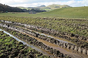
Ruts and mud
How do we (and do we) classify trails which are prone to mud and ruts? Those are typically seasonal, but then can get very bad. Here's a couple of images found of Commons: Duja (talk) 12:39, 13 December 2023 (UTC)


- There was a discussion in the forum about this a while ago. Personally I am not sure if foot_scale is best to express this, it's certainly not sufficient. Osmuser63783 (talk) 23:03, 13 December 2023 (UTC)
- I'd also say, this is a bigger problem - There are some tractor tracks here, two lanes paved with asphalt, in the middle dirt. When it rains heavily, the asphalt lanes become lakes and the middle part mud. People then walk off the track, besides of it. And that where a surface=asphalt looks correct tagging and foot_scale unneeded because of that.
- I'd like to say, something like foot_scale should map the most likely conditions in fair weather. But what about regions, where there are dry and rainy seasons? Post to forums of those regions? --Hungerburg (talk) 23:48, 13 December 2023 (UTC)
Fords
What about fords? There is existing tagging. It is fine. --Hungerburg (talk) 00:04, 14 December 2023 (UTC)
Table structure
I don't think it's a good idea to organize the table by users. Once the proposal gets accepted (fingers crossed), this article should be moved to mainspace as a supplement to Key:foot_scale, so our user names should not be there. Instead, it should be organized by "themes" (roughly, kinds of obstacles) -- my motive for adding the second row was that dense vegetation can affect the traversability (i.e. foot scale) as well.
Also, this is a Wiki and anyone is free to improve it, including removing inappropriate material. For example, I removed File:Landslide (15526290295).jpg -- it depicts a single landslide obstacle on an otherwise casual_walking trail, so it's a pretty bad as a leading example for impeded_walking. We should represent "canonical" trails for the appropriate categories, and leave the hard cases for case-by-case analysis by mappers. For example, newly added File:Scrambling on Pike of Stickle - geograph.org.uk - 2053532.jpg is pretty close (or slightly harder) to what I imagine as a canonical impeded_walking trail and should be somewhere in a top row. Duja (talk) 10:25, 15 December 2023 (UTC)
- Creating a key like this requires a lot of input of as many distinct points of view as possible. Selecting photos depicting the canonical stance should be done from discussions, probably some votes, as @Osmuser63783: suggested in the community forum. TODO : Make the pictures addressable, some shorthand code to identify them to ease that.
- I agree, Pike of Stickle is a border-case regarding walking or not walking. I am certain I can walk there hands-free, while the terrain certainly would impede me. If the community though thinks, this is still beyond what the scale should cover, the picture can remain, as an example of what's outside. In order to get as much as clear a distinction.
- PS: Meanwhile, I invite you to create your own user-page and copy-edit at will. Please link from here! Please do not just drop images, but annotate why inappropriate. Alternatively, I may create a comments section to keep all in one place. Needs the shorthand codes though. --Hungerburg (talk) 11:53, 15 December 2023 (UTC)