Vi:Editing Standards and Conventions
Dưới đây là một số quy ước và chuẩn cho việc biên tập bản đồ. Những thông tin cơ bản về cách biên tập bản đồ , xin vui lòng xem Biên tập
Gán tag
You can assign "tags" ("keys" and "values") to any point (node), street (way), area (closed ways) or relation. You can find a list of suggested tags on the Map Features page. It is recommended that you take a good look at that page and familiarise yourself with the tags which are most widely accepted and recognized by most tools/renderers. Note though that any keys and values are valid and may be employed in OpenStreetMap, and the Map Features page is subject to change, with proposals being voted upon.
The Good practice page has a number of points concerning tagging.
Make sure to visit FAQ for various useful hints, like how to use multiple values for a single tag.
Đường
A physical road, street, footpath, etc. is initially drawn as a series of nodes grouped together to form a way. The way should then be tagged with a highway tag and a name.
Many ways appear the same in most of the OSM editors, however, when rendered they will be displayed in different colours and widths based on the tag values entered.
Tên phố
In the name tag, enter the full name as it appears on the street name signs. Use mixed case with the first letter of each word capitalised (for example, Church Street, not Church street). Do not abbreviate words. There is currently no table of standard abbreviations (St. could be Street or it could be Saint) and it has been decided that this is a rendering issue. i.e. the underlying data should have the full street name. This will allow a renderer to introduce abbreviations as necessary.
Watch out for apostrophes. The same rule applies. If the street sign has an apostrophe, the OSM data should have an apostrophe. There is no obvious consistency; the London Underground station Barons Court is adjacent to Earl's Court, one with an apostrophe, one without.
Also see Bilingual street names
Đường không có tên
Sometimes a road does not have a name (in the real world) That's fairly rare, but it sometimes happens. In this case, enter the highway tag, but not the name tag.
Often a road has a name, but you don't know what it is. This might be because you didn't write it down while you were out surveying. Maybe you used a camera but the picture came out blurry. Or maybe you are sketching over Yahoo! Imagery. These kinds of roads should be drawn in as ways tagged with highway=road as per the guidelines on Yahoo! Aerial Imagery#How to sketch? ... however not everyone follows this, and "sketched" roads are often left untagged or given some other highway tag by a reasonable guess.
Đường một chiều
If traffic can only travel down a road oneway then it is important to draw the way in the direction of travel and then add a oneway=yes.
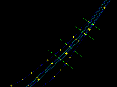
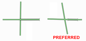
Divided highwaysA divided highway (also separated highway) is any highway where traffic flows are physically separated by a barrier (e.g., grass, concrete, steel), which prevents movements between said flows. While divided highways typically consist of two opposing traffic flows, such as with dual carriageways, they can also consist of three or more divided sections having a combination of same-direction and opposing flows, such as highways with "local" and "express" lanes (whereby entries to and exits from the highway are possible only from the former). Divided highways should be drawn as separate ways. The ways will typically be one way, and should be tagged as such where appropriate. Ways connecting the divided ways should be drawn at locations where movements between the divided ways are possible, that is, where the physical separation is interrupted. Where the divided ways are parallel, which is oftentimes — but not always — the case, their nodes should be positioned so that they are adjacent to each other, which creates a more pleasing aesthetic effect in renderers, especially on curves. It also preserves the information on their mutual separation distance along their whole length. Bùng binh/Nút giao hình xuyếnKiểu đối tượng này được thảo luận chi tiết hơn tại trang này.
Junctions
CầuA bridge is drawn as a separate way. This is one of many situations where a road is no longer represented as a single way, but as several ways arranged end-to-end, each with different tagging. The editors provide an easy way to split a way at a given node, for this purpose. The highway and name tag should be applied to throughout. The short way representing the bridge should additionally be tagged with bridge=yes and layer=1.
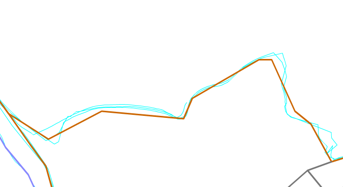
Tagging AreasOn some occasions the feature you wish to tag is not represented by a line (as is the case of a road, river, rail line etc), but by an area. For instance a wooded area, a park, or a lake are all map features which are areas. Create a new closed way which represents the outline of the required area. Annotate this way with the required tagging from the map features page, such as natural=water (for a lake), landuse=forest (for a forest), or leisure=park (for a park), etc. Độ chính xácAccuracy is important. The GPS system provides fixes that can be accurate to 1-10m which is more than good enough for this project. Do bear in mind, however, that a road can be several metres wide and a GPS fix could have been made anywhere in the road or even on the pavement. For many purposes accuracy to a few metres is plenty good enough. What is equally important however is topological accuracy. Do two roads intersect at the same point (a crossroads) or is the intersection offset? This detail may only be a matter of a few metres, but can be the difference between driving instructions that might say at the crossroads go straight ahead or at the junction turn left and then after 10 metres, turn right. When tracing roads — particularly winding, rural ones — you should add enough points to make each curve look like a curve. Of course, this is entirely subjective, as curves made entirely of lines will only ever approximate a "true" curve (which has an infinite number of nodes), and will always look like a series of lines when zoomed in past a certain point no matter how many nodes there are. Any "rule of thumb" as to node spacing and quantity would be arbitrary and capricious. To generalize, though, sharp curves (those having a small radius) require many, closely-spaced nodes, while broad, long-radius curves can consist of fewer nodes having more distance between them. Without a hard-and-fast rule, it is best said to simply use good judgement and strive to seek a balance: on one hand, remember that you are drawing a map, not just a routing diagram; on the other hand, don't try to seek perfection by adding more and more nodes past the point of diminishing returns, keeping in mind that each additional node requires that more data be stored and transferred. Note: Keep in mind that the road in the diagram below is about 20km long. For very short roads you do not need to add that many nodes. How not to do it The above is an example of a very roughly-traced rural 20-kilometer road. Drawing roads like this isn't helpful. When someone comes along to do it properly, he will have to work hard to refine this way by adding lots of points into it and adjust them. Nevertheless it is not recommended to delete existing items without verifying every single node if it bears some tags. How to do it This is the same 20-kilometer road - but this will look much better on the map, and gives the map user a better sense of the curves of the road. Thời gianDates should be in ISO 8601 format, i.e. YYYY-MM-DD. Where a numeric day of week is necessary, Monday=1, Sunday=0 or 7.
Miscellaneous
Topology
WARNING: OpenStreetMap is highly addictive For some people the process of mapping on OpenStreetMap is highly addictive. Take frequent breaks, there is a lot to be done. |


