Tag:landuse=forest
| Description |
|---|
| Forest or woodland, sometimes considered to be restricted to managed woodlands or tree plantations. |
| Rendering in OSM Carto |

|
| Group: landuse |
| Used on these elements |
| Useful combination |
|
| See also |
| Status: de facto |
| Tools for this tag |
|
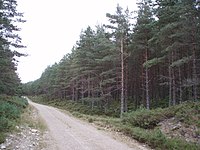
Forest or woodland. Sometimes considered to have the restricted meaning "Managed woodland or tree plantation maintained by human to obtain forest products".
There are major differences in the way this tag & natural=wood are used by different Openstreetmap users. Some use this tag for land primarily managed for timber production, others uses if for woodland that is in some way maintained by humans, some for any forest. This problem is explained in the page Forest.
See the page Forest to understand the usage of this tag and natural=wood.
If you are mapping a forest, understood as a mainly (but not only) wooded area, which is considered in its whole as a single forest, the present tag is to be understood as modelling the physical forest (that is to say, the wooded cover of the area). For the forest in its whole (with its glades, stand variations…), use boundary=forest; for forest compartments, use boundary=forest_compartment.
How to map
Draw an area to match shape of woodland and tag it landuse=forest. If exact match is infeasible then approximate shape is acceptable. As the last resort place a node instead of an area.
Additional tags
- name=* - name of the forest (you may use boundary=forest+name, which was designed for some such cases)
- operator=* - operator of the forest (you should probably use boundary=forest+operator, which was designed for some such cases)
- leaf_type=broadleaved/needleleaved/mixed - describes the type of leaves.
- leaf_cycle=deciduous/evergreen/mixed - describes the phenology of leaves.
- produce=* - Describes the type of produce
- species=* - for species (scientific) name - useful tag to specify which tree species predominate in given area of the forest
- genus=* - The scientific name of the genus of tree - use where species varies or is unknown
Forest compartments
If the area of a forest is subdivided into compartments by the land operator for forestry management, map it using boundary=forest_compartment. Add the identifier as ref=*. Use marker=* to map the markers that denote compartment boundaries on the ground (e.g. marker=post or marker=stone).
Rendering
If leaf_type=* is also set, this can be indicated by appropriate symbols for conifers, deciduous trees and mixed forests.
| Tag | Rendering | Comment | Pictures |
|---|---|---|---|
| leaf_type=broadleaved | 
|
Broadleaved woodland. |  
|
| leaf_type=needleleaved | 
|
Needleleaved woodland. |  
|
| leaf_type=mixed | 
|
Mixed woodland. |  
|
| leaf_type=leafless | 
|
Leafless vegetation |  
|
Related OSM projects
Wiki for all environment and natural tags and projects Environmental OSM.
See also
- Forest for discussion of this tag and natural=wood
- natural=tree - A single tree
- natural=scrub - Uncultivated land covered with shrubs, bushes or stunted trees
- plant_community=* - Describes the plant community of a feature
- taxon=* - Describes the taxon of a feature
- Habitat
- Vegetation - summary of tags for various types of trees and plants
- species=* - for species (scientific) name
- boundary=forest_compartment - A marked subdivision of a wooded area, which is used for planning, management & navigation
- boundary=forest, a tag designed to allow mapping forest as including stand variations (needle-leaved, broadleaved…), but also non-mooded areas, such as screes, ponds, glades…
- landuse=forestry - Another tag for forestry areas (barely used)
Possible tagging mistakes
| ||||||||||||||||||||||||||||||||
