2016 Sri Lanka Floods
| General Information | |
|
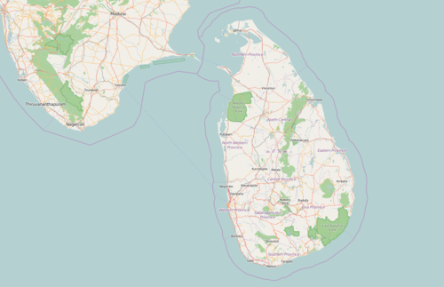
2016 Sri Lanka Floods have impacted a significant area. The Disaster Management Center of Sri Lanka has requested HOT to assist in generating an estimate of the number of buildings affected by flooding in the Kelani River Basin.  Sri Lanka on OpenStreetMap | |
For Aid Organizations
- Link to data sets on HDX (not sure if official COD/FODs) https://data.humdata.org/group/lka
- RiskInfo, Disaster Management Centre data portal (in beta): http://riskinfo.lk/
- HOT Exports for the target area: http://export.hotosm.org/en/exports/61f90387-f4e6-4546-a80b-8b01ec60d123/
Pacific Disaster Center products and sitrep:
PDC continues to closely monitor the recent Floods and Landslides in Sri Lanka. Attached is a PDC Situational Awareness product depicting Accumulated Rainfall for the Past 3 days and 100 Year Major Riverine Basin Flood Hazard Zones. If you would like to view the rainfall accumulation (TRMM) data in real time in DisasterAWARE, please access the Hazard event through the link below and expand the “Default Layers” folder in the product list. You may also search “TRMM” in the “Layers” palette. Additional products will be issued for future advisories as necessary for this event.
Direct link to the Hazard event: http://emops.pdc.org/emops/?hazard_id=59850
If needed, please register for access to PDC's DisasterAWARE here: http://emops.pdc.org/emops/public/registeruser.jsp
Please advise PDC Response below if you require additional support or would like recipients added or removed from this distribution list.
Respectfully,
- Pacific Disaster Center
- response@pdc.org
Map and Data Services
About OpenStreetMap
OpenStreetMap offers an online map (and spatial database) which is updated by the minute. Various tools and services allow data extracts for GIS specialists, Routable Garmin GPS data, Smartphone GPS navigation, and other device-compatible downloads. With an internet connection, regular syncing is possible with open access to the community contributed data as it comes in, with OpenStreetMap's bulk data downloads ideal for use offline. In addition, maps can also be printed to paper.
Browse the Activation Area to get a feel for the data that is currently available. Different map styles including an Humanitarian style can be selected on the right side, and some data may not render (appear) on the map, but could be exported from the underlying database (See export section below).
Paper Maps
Poster size Maps and normal sized paper atlases of custom areas can be printed:
- FieldPapers Paper Maps with grid for field survey or general navigation purposes,
- MapOSMatic Large Paper Maps with grid, street index and POI, good for command centers, hospitals, etc.
Exporting OpenStreetMap data
See Downloading data for instructions on getting large scale map data. See Shapefiles if you need this format to export to GIS tools.
You can find thematic (categorized) layers of OSM data for the target area here, courtesy of the World Bank's Global Facility for Disaster Reduction and Recovery. All timestamps are UTC -5.
You can find a more general collection of OSM data from the HOT exports website here: http://export.hotosm.org/en/exports/61f90387-f4e6-4546-a80b-8b01ec60d123/
With the availability of small communication devices, offline navigation data has proven very useful to humanitarians deployed in foreign countries. We support humanitarian NGOs using navigation data and invite them to give us feedback on the utilization of these devices in the context of field deployments.
About This Humanitarian Activation
About HOT
To learn more about the Humanitarian OpenStreetMap Team (HOT), explore more of our wiki-pages (root: HOT) or our website hotosm.org. We are a global community of mostly volunteers, we are also a US Nonprofit able to contract with organizations (email info at hotosm.org to contact our staff), we are also a 501-c-3 charitable organization.
History of this Activation
Reactivity of the OSM Community
- 30 May - Over One Million Map Changes by just under 400 Mappers using #Sri-Lanka-Floods in their changeset comment!
- 28 May - 125,000+ Buildings have been contributed by 370 Mappers!
- 25 May - 100,000+ Buildings have been contributed by 335 Mappers!
- 23 May - 80,000+ Buildings have been contributed by 300 Mappers!
- 21 May - 50,000+ Buildings have been contributed by 245 Mappers!
- 18 May - HOT received a request to Activate...
Coordination
This Activation is being led by Robert Banick of HOT. The HOT Activation Working Group can be reached via email to Activation @ hotosm.org
Support Team
Mikel Maron, Russell Deffner and Blake Girardot of HOT.
For Mappers
How You Can Contribute

Learn to Map
- Most of our volunteer needs are for remote OSM contributors, visit LearnOSM.org to get started.
- See Sri_Lanka_Tagging_Guidelines for more information on local mapping efforts and guidance.
Mapping Priority
- Please choose from highest priority first
- Experienced mappers are also asked to participate in validating completed tasks. Information on validating can be found here
- Table last updated 31 May 13:00 UTC
| Job No. | Priority | Location | What to map | Imagery Source | Task Mapping Status | Task Validation Status |
|---|---|---|---|---|---|---|
| ACTIVATION PROJECTS | ||||||
| All Complete, Thank You! | Complete | Kelani River Basin | Buildings | Various | Complete | Complete |
| RESILIENCE PROJECTS | ||||||
| Project 1280 | Moderate | Gampaha West | Detailed | Bing | In Progress (60%) | In Progress (54%) |
| Project 1340 | Moderate | Attanagalla | Detailed | Bing | In Progress (26%) | In Progress (2%) |
| Project 1923 | Moderate | Minuwangoda | Buildings | Bing | In Progress (38%) | In Progress (2%) |
| COMPLETE/ARCHIVED | ||||||
| Project 1934 | Complete | Kelani Various | Buildings | Various | Complete (100%) | Complete (100%) |
| Project 1920 | Complete | Aranayake | Buildings and Roads | HIU | Complete (100%) | Complete (100%) |
| Project 1915 | Complete | Eastern Kelani | Buildings | Mapbox | Complete (100%) | Complete (100%) |
| Project 1914 | Complete | Central Kelani | Buildings | Mapbox | Complete (100%) | Complete (100%) |
| Project 1913 | Complete | Western Kelani | Buildings | Mapbox | Complete (100%) | Complete (100%) |
Available Imagery
The default imagery is sufficient, but we have identified an off-set/difference in alignment; Mapbox appears to be the better imagery to use as it more closely matches GPS data in the area.
NOTE: However, many projects in the area were initiated and complete using Bing for alignment, please read the project instructions for which imagery to use for object alignment.
OSM Default Imagery Sources
Mapbox appears in better alignment with GPS data, and more recent, in the area of interest; if cloudy or missing it will be necessary to switch between Bing and Mapbox, and there may also be complete gaps of default imagery coverage; please note this in the Tasking Manager.
Mapbox
Mapbox provides a global imagery source and should be compared to Bing (use Mapbox for alignment if available and not instructed otherwise).
Bing
Bing provides a global imagery data source that is the 'default' Imagery available for OSM (default option in most editors).
Alternative Imagery Sources
How to add/use Alternative Imagery
In many cases better imagery is available than the default; when possible we set up a remote link directly via the Tasking Manager, so there is nothing to do, the iD editor and (as long as enabled) JOSM will automatically add the imagery.
Additionally, with JOSM, it's relatively easy to add special imagery if the license is appropriate for tracing into OSM. For more details see JOSM Imagery Help
Potential Datasources
Mapathon events
- Milehigh Maptime Mapathon 2016-05-19 18:00 - 20:00 MDT
