BSGPSPDA
The given reason is: The domain of the developer belongs to a domain grabber. --Nakaner (talk) 10:07, 4 February 2025 (UTC).
If you know about the current state of affairs, please help keep everyone informed by updating this information. (Discussion)
| BetterSoftwareGPSPDA | ||||||||||||||||||||||||||||||||||||||||||||||||||||||||||||||||||||||||||||||||||||||||||||||||||||||||
|---|---|---|---|---|---|---|---|---|---|---|---|---|---|---|---|---|---|---|---|---|---|---|---|---|---|---|---|---|---|---|---|---|---|---|---|---|---|---|---|---|---|---|---|---|---|---|---|---|---|---|---|---|---|---|---|---|---|---|---|---|---|---|---|---|---|---|---|---|---|---|---|---|---|---|---|---|---|---|---|---|---|---|---|---|---|---|---|---|---|---|---|---|---|---|---|---|---|---|---|---|---|---|---|---|
| Author: | bullstreetboy | |||||||||||||||||||||||||||||||||||||||||||||||||||||||||||||||||||||||||||||||||||||||||||||||||||||||
| License: | (free of charge) | |||||||||||||||||||||||||||||||||||||||||||||||||||||||||||||||||||||||||||||||||||||||||||||||||||||||
| Platform: | Windows Mobile 2003 | |||||||||||||||||||||||||||||||||||||||||||||||||||||||||||||||||||||||||||||||||||||||||||||||||||||||
| Status: | Broken | |||||||||||||||||||||||||||||||||||||||||||||||||||||||||||||||||||||||||||||||||||||||||||||||||||||||
| Version: | 3.5.0.2 (2008-08-08) | |||||||||||||||||||||||||||||||||||||||||||||||||||||||||||||||||||||||||||||||||||||||||||||||||||||||
| Language: | English
| |||||||||||||||||||||||||||||||||||||||||||||||||||||||||||||||||||||||||||||||||||||||||||||||||||||||
| Programming language: | Visual Basic .NET | |||||||||||||||||||||||||||||||||||||||||||||||||||||||||||||||||||||||||||||||||||||||||||||||||||||||
| ||||||||||||||||||||||||||||||||||||||||||||||||||||||||||||||||||||||||||||||||||||||||||||||||||||||||
Introduction
BSGPSPDA is an application for the Windows Mobile PDA/Pocket PC.
- Developer : Bettersoftware
- License Type : Freeware
- Opensource : No - but maybe in the future
- Target platform : Windows Mobile 2003, WM5,WM6.1 with (latest .NET-Framework)
- Dev. language : VB.Net 2005 and OpenNETCF
- Current status : In use by Osmers and contributing to the Map
There is also a version called BSGPS that runs on Windows 2000, XP, Vista, WIndows 7 (64bit) etc. with .NET-Framework.
Screenshots
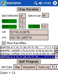
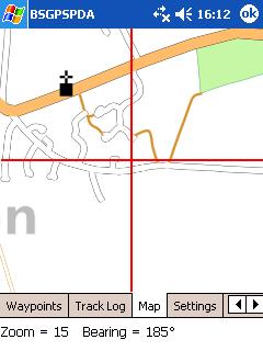
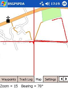
The third image shows a track log overlaid on the map indicating I walked half way around the field and back down the road. Notice how the map has moved between image 2 and 3. Image 2 is indicating I'm in my back garden and image 3 indicates I'm across the road from the footpath. Notice the bug in OSMarender - when it is drawing the Church - it should be north of the road as per the Josm position (it positions it correctly at some zoom levels).
All features on the shown map tracked using BSGPS and BSGPSPDA.
Features
Current
- Displays satellites detected and in use. HDOP, PDOP, VDOP with optional audible alert when fix lost
- Can show raw NMEA data and save to file.
- Waypoints with description and audio recording
- Tracklogs to any selected file, and saves in GPX for uploading to Josm etc.
- "Enter" Button starts, or stops and saves a Tracklog.
- (The big one!) Display map using downloaded OSM tiles and overlay the current trace. Makes it easy to see which roads need to be traced
Planned
- Auto-zoom?
Versions
- v1.7.0 18/09/07 Moved settings to new tab, more GPS detail on main tab, option to save Logged MNea data to file
- v1.8.0 19/09/07 Minimise button added, Quit Program button added
- V1.8.0 24/09/07 New Tab "Tiles" added. Download of Missing Tiles from OSM added with auto create of folder structure. Start Track log on Accept/Enter button on Map screen added
- V1.8.1 25/09/07 Bug fix - Start/Stop track log on Accept/Enter message not showing.
- V1.9.0 02/10/07 BIG changes - back up your old version and expect some bugs. Regional Settings (Dutch (Netherlands)) Bug fixed. Dutch numbers contain commas ie 123.456,00. This resulted in corrupt Tile Addresses. BSGPSettings.txt now obsolete - all settings now held in Registry - The settings tab has been amended for more User friendly selecting Map location and Layer. PDA prevent power off option added. Previously, if the PDA shut down as a result of User selected power saving options the program would crash. On exit the User power saving options are restored. Auto Start receiver option added. If this option is selected then, on program load, the receiver is started automatically and the program goes straight to the Map tab. Simulate lat/lon position option added. Enter a lat/lon of anywhere in the world and the OSM Map will be displayed if the tiles have been downloaded already. If not go to the Tiles tab and download the tiles and then switch to map. This will help when planning mapping trips. Plus minor performance tweeks - I hope!
- V1.9.7 16/10/07 Multiple bug fixes plus code revision in preparation for threading (which I hope will solve SteveC's delay problem)
- V2.0.0 23/10/07 Threading implemented. If anyone still has map lag/delay problems please let me know. Same tile downloaded more than once prevented.
- V2.0.3 08/12/07 User selectable Expansion slot name. Default track Log name.
- V2.0.6 20/12/07 Osmarender URL change. Refresh all Tile.
- V2.0.7 24/01/08 Windows Mobile "Feature Fix" - To prevent the PDA shutting down "Windows" needs the "On external Power" to be unchecked.
- V3.5.0.0 01/08/08 Rewritten for framework 3.5 and delay problem seems to be solved
Wish List
Moved to Discussion page
Getting the tiles
PDA with internet connection
Version 1.8.0 and > now has a Tab "Tiles" and Missing tiles can be downloaded directly if the PDA has an internet connection. During the download the folder structure for layer,zoom and columns is automatically created.
PDA without internet connection, downloading tiles and saving them on PDA
The application will generate a file listing the OSM tiles required for the areas travelled through. This can be used with the Windows version of the application (BSGPS) to download the tiles. For non-Windows users User:Steevc has a Python script to do this, but it needs some work. The file MissingTiles.txt can be found in \My documents\ or \SD-MMC Card\. The directory tree created by the script must be placed in the proper directory like \SD-MMC Card\OSM\OSMarender\ and BSGPSPDA should then be told in settings too look at Storage card for the tiles. There is another script at User:JLS/BSGPSPDA to update tiles after a while.
How to copy tiles from desktop or Laptop to PDA
When you copy downloaded files from your desktop or laptop computer BSGPS (windows version) you have to copy OSM folder with directory structure from default file location typically found at C:\Program Files\Bettersoftware\BSGPS\Images\Maps then copy OSM foulder and phaste to \My documents\ or \SD-MMC Card\ OSM folder should NOT put inside the folders of SD-MMC Card BSGPSPDA will not find the OSM folder inside the directory
Rendering tiles and saving them on PDA
Since the client will download the data and render the tiles, this is the only way to be sure the tiles on your PDA are absolutely up to date, Beyond this you can create tiles for an area in all zoom levels from 12 to 17.
- Make the Tiles@Home client run on your system.
- In tilesAtHome.conf add a line
LocalSlippymap=./Osmarender
- create a directory called Osmarender in the tilesAtHome directory
- run perl tilesGen.pl xy 1234 1234 (where 1234 1234 are the xy coordinates of a zoom 12 tile you want to have on your PDA)
- copy all needed zoom levels to your PDA (note the tiles@home client generates a "tile" and a "maplint" subdirectory, you don't need this!)
You dont need an upload account, since your client will not upload anything.
Re-rendering existing tiles
From User:JLS : Inspired by User:Steevcs script to download missing tiles for BSGPSPDA I also wrote a script to redownload old tiles. See User:JLS/BSGPSPDA.
Usage
You can change zoom level with the scrollwheel on the side of the PDA, or by Up and Down with the joystick (at least on Acer n35 and Yakumo Alpha).
Hitting the joystick left or right will change the view ( GPS Status / Map / Waypoints / ...).
To start or stop the receiver push the scrollwheel on the side, or the joystick if possible, in GPS Status view. To start or stop a tracklog push the scrollwheel on the side, or the joystick if possible, in map view. To save a position as waypoint push the scrollwheel on the side, or the joystick if possible, in Waypoint view (next hit starts Recording mode, next hit stops recording mode).
Cross Platform?
Is anyone interested in helping with conversion to other platforms? My experience in this area is NILL.


