Key:building:part
| Description |
|---|
| To mark a part of a building, which has attributes, different from such ones at other parts. |
| Group: buildings |
| Used on these elements |
| Documented values: 6 |
| Useful combination |
| See also |
| Status: de facto |
| Tools for this tag |
|
Areas with the tag building:part=* allow you to split a building into parts that differ in terms of some attributes or the function.
Those areas are optional, and used in addition to a building=* area. building:part=* areas should always be contained within a building=* area that represents the entire building. If building:part=* is used for 3D-tagging, keep in mind that the building=* area might not get rendered by some 3D-renderers if building:part=* is used anywhere in the building.
How to use
- Main article: Simple 3D buildings
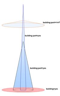
Use building:part=yes for parts of the building which only have different attributes (building:levels=* and height=*). Use building:part=(type of building) for parts of the building which have a different function and possibly attributes (e.g. building:part=roof, building:part=retail or building:part=barn).
In addition to the different ways tagged building:part=*, there should be one area (closed way or multipolygon) marking the outline of the whole building, tagged with building=*. For complex buildings it is also recommended to use a type=building relation to group together the outline way and the building:part=* ways.
Where a building has been split into parts, a building outline has still to be drawn of the whole building way and should have the tags building:levels=* and height=*. These values should be the maximum of all the building parts. A building that has a three-story part and a six-story part is still a six-story building. This may at times result in two ways sharing the same building nodes if the ground building:part is identical in circumference as the total building outline. A two part building is thus mapped with three objects regardless if with or without a type=building relation.
Values
In general, all values for building=* are also valid for building:part=*, though the latter also has some exclusive values which don't otherwise make sense as a separate building:
| Key | Value | Comment | Photo | Taginfo |
|---|---|---|---|---|
| building:part | yes | A generic building part. This value is the default for most building parts. | ||
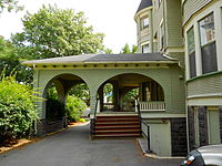
| building:part | porch | A roof which covers the entrance of a building. See building=roof for other types of roofs. | 
|
|
| building:part | balcony | An overhanging structure of a building which allows residents to be somewhat on the outside. | 
|
|
| building:part | column | A structure to support structures of a building which are in the air and would otherwise collapse on themselves. See indoor=column for columns on the inside and man_made=column for columns in general. | 
|
|
| building:part | corridor | A connection between two buildings. Can be on the ground or in the air (compare building=bridge when mapped as its own building). | 
|
|
| building:part | steps | Part of a building which is shaped like steps. See also highway=steps for steps as routeable ways. | 
|
Tags to use in combination
- building:levels=* – number of levels in this part
- building:colour=* – colour of this building part
- building:material=* – material of this building part
- roof:shape=* – roof shape
- roof:colour=* – roof colour
- roof:material=* – roof material
Optional, if known or needed:
- roof:levels=* – roof levels, for roof:shapes other than flat
- height=* – height in metres, if known
- description=* – an optional description of what this building part is
- min_height=* – at what height this building part starts, if it doesn't start from the ground
- building:min_level=* – from which floor this building part starts, if it doesn't start from the ground
Common mistakes
- Missing parts: If a building's parts cover only part of the building outline, the remainder of the building may not be visible in a standard-compliant 3D renderer.
Possible tagging mistakes
Please note that clement-lagrange's fork (abandoned, last activity in 2014 and project disabled issue tracker) of OSMTools Indoor makes heavy use of the buildingpart=* tag.
See also
Indoor mapping
The building tag (and its parts) is about "gross" buildings, i.e. including walls, roofs and other structure. To map the inner divisions (spaces) of buildings, please refer to Indoor mapping and specifically to the concept with the widest acceptance: Simple Indoor Tagging. Some potentially useful tags for "inner" building parts:
