Community Updates/2011-03-14
Community Update from 14 March 2011 to 20 March 2011 (week 2011-11)
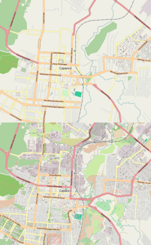
Image Of the Week 2011-11City of Saransk was mapped in only 50 hours. User osmisto has organized the first Russian online mapping party: it's still cold outside, so almost everyone attended. The pie, animation (4 MB), forum. |
Project Of The Week : Instrument Shop
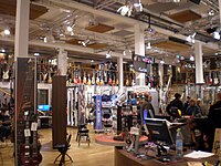
What I really need, right now, is an ukulele. I could order one, overnight from the on-line ukulele store, but I need it now, and prefer to shop locally. Let's just have a quick look at the map.
What's that you say? Steve's Ukulele Kwikee Mart, is right round the corner? How convenient.
The Project of the Week is to add your local musical instrument shop.
News
- MapQuest update their Critical address file
- Another imagery update for Côte d'Ivoire
- OSM is accepted in the Google Summer Of Code 2011. We are looking for mentors!
- How to add data by the Australian goverment [1]
- Crisismapping of the 2011 Sendai earthquake and tsunami needs your help! It's a big topic on all channels.
Events
- South America Foss4G Conference http://www.foss4gchile.org/blog/primer-foss4g-sudamericano/
- User:SteveC gives a Talk at Yale school at 24.03. [2]
Lists Talks
Japan Crisis followup
After the big crisis in Japan, mappers and the HOT team have become very active in the region. As for Haiti, everyday export and calculations are done on OSM data : GPS maps, verification tools, dump of data, ...
The effort is still in action so if you want to help check the 2011 Sendai earthquake and tsunami page and hot.openstreetmap.org
Sidewalks or Footway
Currently there is no consensus on how to map sidewalks of a street. There are currently two possibilities : the sidewalk=* or the much more used Proposed features/Footway.
While people seem to agree on the usage of Footway, some prefer the term "sidewalk" to "footway" so another proposal has appeared to tag with highway=footway + footway=sidewalk.
RFC : Individual Parking
Over the last months more and more high resolution satellite images were made available to mappers. A lot of them are good enough to identify single parking spaces, especially with special symbols on them, like disabled parking, which again would allow much more detailed mapping of such areas. The current mapping scheme with just the tag amenity=parking isn't sufficient to represent this high density of information. Therefore I wrote this proposal as an addition, not as a replacement, to the current mapping scheme for parking spaces.
This proposal adds a bunch of tags to complete the old parking scheme.
Add your comments on the Talk Page
OSM Licence violations
OSM is becoming increasingly used and obviously, the number of licence violations increases. The Lacking proper attribution page refers to those sites but some users have asked if there is a reliable process to handle this kind of problem.
The LWG usually handles submitted requests like this.
Thanks
Big Thanks to : Kreon, Alan, Harry Wood, AndiPersti, Glen, Firefishy and !i!

