ES:Tag:highway=primary
| Descripción |
|---|
| Una vía de circulación que enlaza grandes ciudades. Dentro de las ciudades, una arteria principal. |
| Representación en OSM Carto |

|
| Grupo: viales |
| Usado en estos elementos |
| Implica |
| Combinaciones útiles |
| Estado: de facto |
| Herramientas para esta etiqueta |
Si comprendes el artículo original en inglés, por favor, ayuda a completar esta traducción al español. Lee las instrucciones sobre cómo traducir este wiki.
Parece que nadie está trabajando en la traducción en este momento. Anímate y colabora en la tarea de traducción.
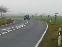
Una carretera importante que une grandes ciudades, en los países desarrollados normalmente con 2 carriles. En las zonas con infraestructuras peores la calidad de las carreteras puede ser mucho peor. El tráfico en ambos sentidos no suele estar separado por una barrera central.
En las ciudades, highway=primary se utiliza generalmente para etiquetar las arterias principales.
Cómo mapear
Para mapear una simple carretera primaria, sólo tiene que dibujar una línea para ello. Seleccione todas las vías que pertenecen a la carretera y etiquétalas con highway=primary. Use oneway=yes cuando no sea posible conducir en ambos sentidos en la carretera. Asegúrese de que el camino apunta en la misma dirección que el de un solo sentido, de lo contrario invierta la dirección o use oneway=-1.
Para adjuntar más información para la carretera debe añadir más claves.
- name=Nombre de la carretera
- maxspeed=Número indica la velocidad máxima permitida
- minspeed=Número indica la velocidad mínima que debe alcanzarse para usar la autopista
- ref=nombre de referencia Por ejemplo A 1, E 22
Situaciones especiales
En el caso de que no tenga una carretera normal, debería echar un vistazo a estos sitios:
- bridge=yes - Si la carretera pasa por una calle o una vía fluvial.
- tunnel=yes - Si la carretera pasa por debajo de una calle o una vía fluvial.
Equivalencia internacional
| País | Descripción | más |
|---|---|---|
| Greece | 2nd-tier National Roads | WikiProject Greece § Road Network |
| Italy | Strada Statale (SS) or Strada Regionale (SR) | The "SSs" are mostly primary. You should also indicate the name of the highway, if it has one, example:
"SRs" can be tagged as primary as well, if they have a relevant role in linking two major cities. In general the highway-tag is not representing the administrative class but the importance of the connection. By default this kind of highway is rendered:
|
| Switzerland | Hauptstrasse | There are two kind of "Hauptstrassen" in Switzerland:
In contrast to other routes, for example cycling or hiking routes, we do not use relations to model numbered "Hauptstrassen" in Switzerland, use ref=number as described above. |
| United States | Primary highway or arterial road. | U.S. Highways are mostly primary. You should also indicate the name of the highway if it exists, example:
Some State Roads or State Routes may also be primary, if they have a significant role in linking two major cities. By default this kind of highway is rendered:
|
| Brazil | Via arterial urbana (urban arterial way), estrada estadual (state road), >50-60 km/h | |
| Philippines | Other national roads that is used as a city/ arterial road rather than an intercity road, or a connector, if it only feeds secondary/tertiary roads. Provincial roads linking municipalities with a major highway. Roads linking a city/municipal center (poblacion) with a major national highway. | National roads usually fall as trunk highways, as they carry most intercity traffic, but some national roads should be tagged primary if they are usually roads serving local traffic in a city/rural area or a connector between two trunk highways, when it feeds roads tagged as secondary or tertiary. |
| Venezuela | Es la red de carreteras regionales que conectan las ciudades y poblados más importantes de cada Estado. |
| ||||||||||||||||||||||||||||||


