FacilMap
| FacilMap | ||||||||||||||||||||||||||||||||||||||||||||||||||||||||||
|---|---|---|---|---|---|---|---|---|---|---|---|---|---|---|---|---|---|---|---|---|---|---|---|---|---|---|---|---|---|---|---|---|---|---|---|---|---|---|---|---|---|---|---|---|---|---|---|---|---|---|---|---|---|---|---|---|---|---|
| Author: | Candid Dauth | |||||||||||||||||||||||||||||||||||||||||||||||||||||||||
| License: | GNU AGPL (free of charge) | |||||||||||||||||||||||||||||||||||||||||||||||||||||||||
| Platform: | Web | |||||||||||||||||||||||||||||||||||||||||||||||||||||||||
| Status: | Active | |||||||||||||||||||||||||||||||||||||||||||||||||||||||||
| Version: | 4.0.0 (2024-03-29) | |||||||||||||||||||||||||||||||||||||||||||||||||||||||||
| Languages: | ||||||||||||||||||||||||||||||||||||||||||||||||||||||||||
| Website: | facilmap.org | |||||||||||||||||||||||||||||||||||||||||||||||||||||||||
| Source code: | FacilMap/facilmap GitHub | |||||||||||||||||||||||||||||||||||||||||||||||||||||||||
| Programming language: | TypeScript | |||||||||||||||||||||||||||||||||||||||||||||||||||||||||
|
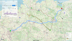
A privacy-friendly, open-source versatile online map that combines different services based on OpenStreetMap and makes it easy to find places, plan trips and add markers, lines and routes to custom maps with live collaboration. |
||||||||||||||||||||||||||||||||||||||||||||||||||||||||||
| ||||||||||||||||||||||||||||||||||||||||||||||||||||||||||
FacilMap (facilmap.org) is a privacy-friendly, open-source versatile online map that combines different services based on OpenStreetMap and makes it easy to find places, plan trips and add markers, lines and routes to custom maps with live collaboration. Features include:
- Choose between different map styles for roads (Lima Labs, Mapnik, Map1.eu), topography (OpenTopoMap), cycling (CyclOSM, OpenCycleMap, Hike & Bike Map, Waymarked Trails), hiking (Hike & Bike Map, Waymarked Trails), public transportation (Openptmap), water navigation (FreieTonne), …
- Search for places and show their information (website, opening hours, …) (using Nominatim)
- Calculate routes and adjust them by dragging, optionally with an elevation profile and details about road quality (using OSRM hosted by Mapbox and OpenRouteService)
- Show POIs on the map (amenities, attractions, businesses, …) (inspired by OpenPoiMap, using the Overpass API hosted by Kumi Systems)
- Smartphone-friendly interface and Progressive Web App
- Create collaborative maps, add markers, lines and routes and collaborate live through a share link
- View GPX/KML/OSM/GeoJSON files or import them to a collaborative map
- Export collaborative maps to GPX or GeoJSON to import them into OsmAnd or other apps
- Link or embed a read-only or editable version of a collaborative map on your website
- Define different types of markers/lines with custom form fields to be filled out
- Create custom views where markers/lines are shown/hidden based on their form field values
- Define custom styles of markers/lines and routes and generate a legend automatically
- Export the field values of markers/lines as HTML or CSV to import them into a spreadsheet
- Programmatically read and modify collaborative maps through a Socket.io API
- Extensive user and developer documentation.
To report bugs, please use the issue tracker on Github.
FacilMap is maintained by Candid Dauth.
OSM analysis tools
FacilMap has some hidden functionality to help mappers analyze OpenStreetMap data, in particular changesets and route relations. It is the successor of OSM History Viewer and OSM Route Manager. These functions are documented on FacilMap/OSM Analysis Tools.
