Openptmap
| Openptmap | |
|---|---|
 Munich, Germany | |
| Slippy map: | facilmap.org |
| Style website: | github |
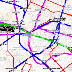
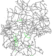
openptmap shows public transport lines. Depending on the zoom level, bus and tram lines are displayed in addition to the railway lines. The tiles have a transparent background and can thus be overlayed over any other layer.
The original version on https://openptmap.org/ no longer exists and seems to be abandoned. A backup of the original style files is available on GitHub. A rendering of the original tiles is now being served from https://pt.facilmap.org/ and can be displayed on FacilMap.
Motivation and Purpose
Between autumn 2010 and spring 2011 due to hardware problems the very advanced and commonly used Openbusmap had not been fully available any more (unavailable tiles, no data updates). For this reason the author of openptmap was searching for a temporary replacement and finally programmed a simple Slippy Map which shows different means of public transport in different colors. These are the limitations in comparison to Openbusmap:
- just one interactive function (timetable link for Europe)
- limited to zoom levels 4 - 17
- line numbers are attached to the lines in an unordered manner
However, there are some useful new features also:
- public transport network grid without background available
- optional backgrounds: Mapnik and CycleMap (original Openptmap website only)
- different background luminances (original Openptmap website only)
- DB railway timetable per mouse click (from zoom 15) - basis: uic_ref, ref_name, name (original Openptmap website only)
- aerial lifts are displayed
- there is no rendering on request, i.e. you need not to wait for rarely accessed tiles to be rendered (original Openptmap website only)
Despite the limitations, the openptmap can be useful in these situations:
- you added a new pt line to OSM and want to review it
- you want to get an overview of the pt network without interfering background
- to find out the departure times of buses/trains at nearby stations
Legend
Color Meaning Tag Deprecated Tag black railway route=train line=rail green S-Bahn route=light_rail
route=train + ref=S*line=rail blue subway route=subway line=subway violet tram
monorail
funicularroute=tram
route=monorail
route=funicularline=tram
red bus route=bus line=bus dark red trolleybus route=trolleybus brown aerial lift route=aerialway pink ferry route=ferry line=ferry
Station Names in OSM Database
In general, the name=* tag is used. For the links to Deutsche Bahn timetables, the uic_ref=* tag is preferred. Bus and tram stations usually do not have a uic number, but they can be identified by the station name, followed by the city name. Example: ref_name=Steintor, Hannover
Map Update
The map is usually updated once a day (original Openptmap website only). You can expect new edits to be displayed within about 12 to 48 hours. There are no updates on the fly, that means, each tile of the public transport layer can be accessed directly because it has already been rendered.
Create your own Map
In case you want to create your own openptmap or use it as a template for a new specialized map, please have a look at the openptmap installation page.
An alternative is the facilmap/openptmap docker image.
