File:Br-sp-der-hierarquia-funcional-regional.jpg
Jump to navigation
Jump to search

No higher resolution available.
Br-sp-der-hierarquia-funcional-regional.jpg (612 × 397 pixels, file size: 41 KB, MIME type: image/jpeg)
Summary
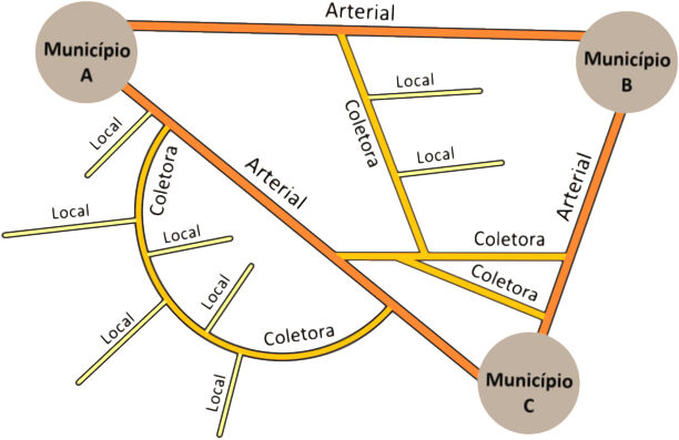
Hierarquia funcional das vias regionais e rurais no Brasil, segundo o Manual Básico de Estradas e Rodovias Vicinais do DER-SP, pág. 13.
Licensing
![]()
This file has been released into the public domain by the copyright holder, its copyright has expired, or it is ineligible for copyright. This applies worldwide.
Please, please use more specific template such as {{PD-self}} / {{PD-creator}} / {{PD-shape}} / {{PD-USGov}} / {{PD-old}} / {{PD-RU-exempt}} ... This template is not making clear why this work is in the public domain.
Please, please use more specific template such as {{PD-self}} / {{PD-creator}} / {{PD-shape}} / {{PD-USGov}} / {{PD-old}} / {{PD-RU-exempt}} ... This template is not making clear why this work is in the public domain.
File history
Click on a date/time to view the file as it appeared at that time.
| Date/Time | Thumbnail | Dimensions | User | Comment | |
|---|---|---|---|---|---|
| current | 15:25, 14 April 2025 | | 612 × 397 (41 KB) | Ftrebien (talk | contribs) | Hierarquia funcional das vias regionais e rurais no Brasil, segundo o Manual Básico de Estradas e Rodovias Vicinais do DER/SP, pág. 13. |
You cannot overwrite this file.
File usage
The following page uses this file: