IT:Featured images/Apr-Jun 2017
Jump to navigation
Jump to search
Queste sono immagini degne di nota che sono state segnalate come i migliori esempi di mappatura in OpenStreetMap o come utile dimostrazione del progetto OpenStreetMap.
Se conosci un'altra immagine di qualità, la puoi nominare in Proposte di immagini di qualità (en).
| ← da aprile a giugno 2016 | ← da gennaio a marzo 2017 | da luglio a settembre 2017 → | da aprile a giugno 2018 → |
Galleria di immagini notevoli, da aprile a giugno 2017
Dettagli e didascalie
Settimana 14 (da lunedì 3 aprile 2017 a domenica 9 aprile 2017) [Edit]
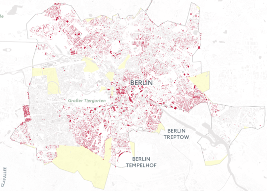
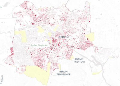
- English : Illustrating the scale of destruction in Aleppo, Syria, by reprojecting it onto OpenStreetMap buildings of Berlin: hanshack.com.
- italiano : Una visualizzazione dell'entità delle distruzioni ad Aleppo in Siria, riproiettate sugli edifici di Berlino presenti in OpenStreetMap: hanshack.com.
Settimana 15 (da lunedì 10 aprile 2017 a domenica 16 aprile 2017) [Edit]
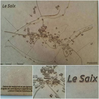
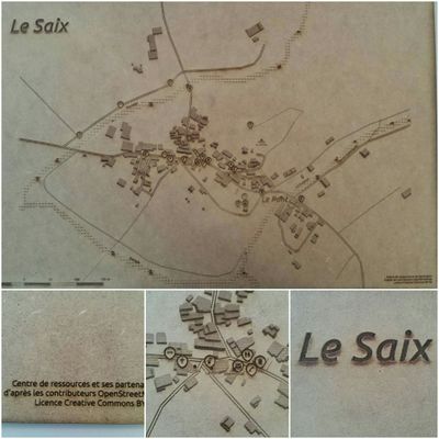
- English : The village of Le Saix (Hautes-Alpes, France) mapped in OpenStreetMap [1] and printed with a laser cutter. A collaboration between Centre de ressources, Apitux, Camille Bissuel and Planète Champsaur, made in Fab'Alpes in Gap.
- italiano : Il villaggio di Le Saix (Hautes-Alpes, Francia), mappato con OpenStreetMap [2] e stampato col taglio laser. Una collaborazione tra il Centre de ressources, Apitux, Camille Bissuel e Planète Champsaur, realizzata al Fab'Alpes di Gap.
Settimana 16 (da lunedì 17 aprile 2017 a domenica 23 aprile 2017) [Edit]
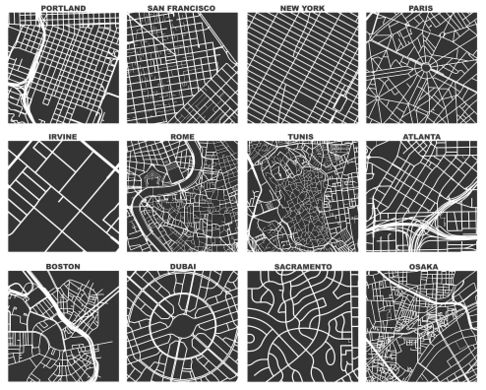
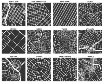
- English : Geoff Boeing created OSMnx, a tool which uses OSM data to compare street networks and urban forms. In the image you can see one square mile extracts of some city centers around the world. Read more about Geoff's work on his blog.
- italiano : Geoff Boeing ha creato OSMnx, uno strumento che usa i dati di OSM per confrontare le reti stradali e le forme urbane. Nell'immagine si possono vedere degli estratti quadrati di un miglio di lato dei centri di alcune città nel mondo. Per ulteriori informazioni sul lavoro di Geoff consultare il suo blog.
Settimana 17 (da lunedì 24 aprile 2017 a domenica 30 aprile 2017) [Edit]
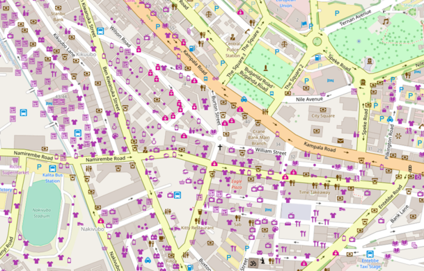
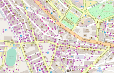
- English : In 2017 we will have the first ever State of the Map Africa! It will be held in Kampala, Uganda’s capital, from 8th to 10th July. Here we see the well mapped Kampala city centre.
- italiano : Nel 2017 ci sarà il primo State of the Map Africa! Si terrà a Kampala, la capitale dell’Uganda, dall’8 al 10 luglio. Questo è il centro di Kampala, già ben mappato.
Settimana 18 (da lunedì 1 maggio 2017 a domenica 7 maggio 2017) [Edit]
- English : Kartegraphik has been doing handmade papercut maps based on OpenStreetMap data. This image is a map of Monterey, California. See more at kartegraphik.com.
- italiano : Kartegraphik realizza a mano delle mappe basate sui dati di OpenStreetMap ritagliando la carta. Questa immagine è una mappa di Monterey, in California. Ulteriori informazioni all'indirizzo kartegraphik.com.
Settimana 19 (da lunedì 8 maggio 2017 a domenica 14 maggio 2017) [Edit]
- English : A presentation of mapscii [3], a zooming panning view of OpenStreetMap rendered as ASCII art (also including Braille dot patterns).
- italiano : Una presentazione di mapscii [4], una vista di OpenStreetMap con zoom e pan resa come ASCII art (include anche simboli Braille).
Settimana 20 (da lunedì 15 maggio 2017 a domenica 21 maggio 2017) [Edit]
- English : The top ten mappers (yellow) account for most of the data contributed in London so far in 2017. Andy Allan presented "Who is mapping London?" at the recent OSM Q&A event.
- italiano : I 10 mappatori più attivi (in giallo) totalizzano la maggior parte dei dati inseriti a Londra nel 2017 finora. Andy Allan ha presentato "Who is mapping London?" al recente evento OSM Q&A.
Settimana 21 (da lunedì 22 maggio 2017 a domenica 28 maggio 2017) [Edit]
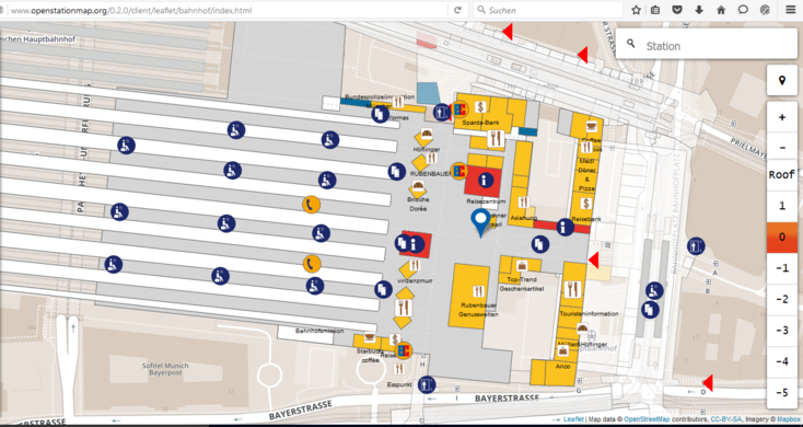
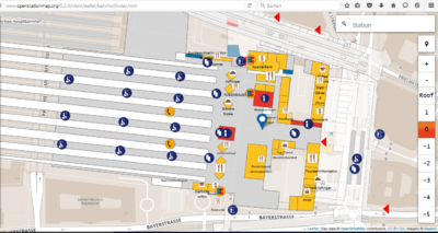
- English : Large railway stations often include shops and other features inside them. OpenStationMap (openstationmap.org) reveals indoor mapping data (where it has been added) specifically for railway stations.
- italiano : Le grandi stazioni ferroviarie spesso includono negozi e altri servizi. OpenStationMap (openstationmap.org) rivela i dati dell'indoor mapping (dove sono stati aggiunti) in maniera specifica per le stazioni ferroviarie.
Settimana 22 (da lunedì 29 maggio 2017 a domenica 4 giugno 2017) [Edit]
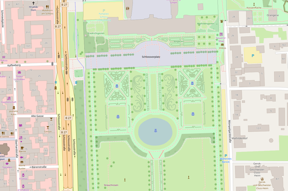
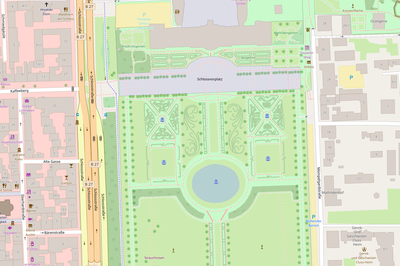
- English : Nammala from the Mapbox data team gave a round-up of some recent interesting edits, mostly vandalism detected using osmcha, but also this very detailed mapping of the Gardens of Ludwigsburg Palace made by Paddy1984.
- italiano : Nammala del Mapbox data team fatto un riepilogo di modifiche recenti interessanti, principalmente vandalismi individuati usando osmcha, ma anche questa mappatura dettagliata dei giardini del castello di Ludwigsburg fatta da Paddy1984.
Settimana 23 (da lunedì 5 giugno 2017 a domenica 11 giugno 2017) [Edit]
- English : Mapathons can be made more fun and interesting when your work is displayed on a wall of monitors for everyone to see! This mapathon, supported by the OSM Philippines community, was organized by User:GOwin as part of his MapAmore initiative and was hosted by the City of San Juan's Central Emergency and Disaster Operations Center (CEDOC).
- italiano : I mapathon possono esser resi più divertenti e interessanti quando il lavoro è visualizzato su un video wall per farlo vedere a tutti! Questo mapathon, sostenuto dalla comunità filippina di OSM, è stato organizzato da User:GOwin nell'ambito della sua iniziativa MapAmore ed è stato ospitato dal CEDOC (City of San Juan's Central Emergency and Disaster Operations Center).
Settimana 24 (da lunedì 12 giugno 2017 a domenica 18 giugno 2017) [Edit]
- English : Some of the 250 attendees of State of the Map France 2017, which took place 2–4 June in Avignon.
- italiano : Alcuni dei 250 partecipanti allo State of the Map France 2017 che si è tenuto dal 2 al 4 giugno ad Avignone.
Settimana 25 (da lunedì 19 giugno 2017 a domenica 25 giugno 2017) [Edit]
- English : The iD editor showing a new data layer from Mapillary, with road signs detected within the street-level imagery.
- italiano : L'editor iD può visualizzare un nuovo livello di dati da Mapillary che mostra i segnali rilevati nelle immagini a livello stradale.

