Is OSM up-to-date
| Is OSM up-to-date? | ||||||||||||||||||||||||||||||||||||||||||||||||||||||||||||||||||||||||||||||||||||||||||||||||||||||||
|---|---|---|---|---|---|---|---|---|---|---|---|---|---|---|---|---|---|---|---|---|---|---|---|---|---|---|---|---|---|---|---|---|---|---|---|---|---|---|---|---|---|---|---|---|---|---|---|---|---|---|---|---|---|---|---|---|---|---|---|---|---|---|---|---|---|---|---|---|---|---|---|---|---|---|---|---|---|---|---|---|---|---|---|---|---|---|---|---|---|---|---|---|---|---|---|---|---|---|---|---|---|---|---|---|
| Author: | Francesco Frassinelli | |||||||||||||||||||||||||||||||||||||||||||||||||||||||||||||||||||||||||||||||||||||||||||||||||||||||
| License: | GNU AGPL (free of charge) | |||||||||||||||||||||||||||||||||||||||||||||||||||||||||||||||||||||||||||||||||||||||||||||||||||||||
| Platform: | Web | |||||||||||||||||||||||||||||||||||||||||||||||||||||||||||||||||||||||||||||||||||||||||||||||||||||||
| Version: | 2.2 (2022-06-05) | |||||||||||||||||||||||||||||||||||||||||||||||||||||||||||||||||||||||||||||||||||||||||||||||||||||||
| Language: | English
| |||||||||||||||||||||||||||||||||||||||||||||||||||||||||||||||||||||||||||||||||||||||||||||||||||||||
| Website: | https://is-osm-uptodate.frafra.eu | |||||||||||||||||||||||||||||||||||||||||||||||||||||||||||||||||||||||||||||||||||||||||||||||||||||||
| Source code: | https://github.com/frafra/is-osm-uptodate | |||||||||||||||||||||||||||||||||||||||||||||||||||||||||||||||||||||||||||||||||||||||||||||||||||||||
| Programming languages: | Python and JavaScript | |||||||||||||||||||||||||||||||||||||||||||||||||||||||||||||||||||||||||||||||||||||||||||||||||||||||
|
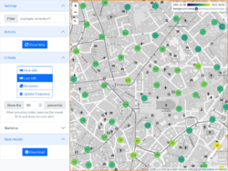
Screenshot of Is OSM up-to-date? showing nodes in Milano using different colours based on when they have been modified last time |
||||||||||||||||||||||||||||||||||||||||||||||||||||||||||||||||||||||||||||||||||||||||||||||||||||||||
| ||||||||||||||||||||||||||||||||||||||||||||||||||||||||||||||||||||||||||||||||||||||||||||||||||||||||
Is OSM up-to-date? (is-osm-uptodate.frafra.eu) looks for old and potentially outdated nodes, built upon Ohsome API (starting from version 1.6).
Main goal
The rationale behind this application is that nodes that have not been modified since a long time have a higher probability of containing outdated information: having a map showing features colored differently based on their last modification time allow the user to easily spot potentially wrong values and positions.
Features
Clicking on a point opens a pop-up, which displays basic information and useful links to openstreetmap.org functionalities and references to wiki.openstreetmap.org. The refresh button fetches new nodes contained in the portion of the map that the user is looking at. It is also possible to share the current view with other users just copying the link because it contains a hash which represents the last position and zoom level.
The application provides simple REST API and a command line interface which do not require a web server or a web browser; the output is a GeoJSON valid file.
Version 2.0 adds support for tiles via a silly map/TMS endpoint and caching using Redis.
Development
- Is OSM up-to-date? GitHub Repository and issue tracker.
- The README gives details about installing and running Is OSM up-to-date?
- Is OSM up-to-date? is developed by Frafra. Sources are licensed under AGPLv3.
