Karta GPS
| Karta GPS | ||||||||||||||||||||||||||||||||||||||||||||||||||||||||||||||||||||||||||||||||||||||||||||||||||||||||
|---|---|---|---|---|---|---|---|---|---|---|---|---|---|---|---|---|---|---|---|---|---|---|---|---|---|---|---|---|---|---|---|---|---|---|---|---|---|---|---|---|---|---|---|---|---|---|---|---|---|---|---|---|---|---|---|---|---|---|---|---|---|---|---|---|---|---|---|---|---|---|---|---|---|---|---|---|---|---|---|---|---|---|---|---|---|---|---|---|---|---|---|---|---|---|---|---|---|---|---|---|---|---|---|---|
| Author: | Karta Software Technologies | |||||||||||||||||||||||||||||||||||||||||||||||||||||||||||||||||||||||||||||||||||||||||||||||||||||||
| License: | Proprietary (free of charge) | |||||||||||||||||||||||||||||||||||||||||||||||||||||||||||||||||||||||||||||||||||||||||||||||||||||||
| Platforms: | Android and iOS | |||||||||||||||||||||||||||||||||||||||||||||||||||||||||||||||||||||||||||||||||||||||||||||||||||||||
| Version: | 2.48.05 (Android) & 2.49.01 (iOS) (2024-11-12) | |||||||||||||||||||||||||||||||||||||||||||||||||||||||||||||||||||||||||||||||||||||||||||||||||||||||
| Languages: | Arabic, Czech, Danish, English, Spanish, Finnish, French, German, Greek, Indonesian, Italian, Japanese, Korean, Malay, Norwegian Bokmål, Dutch, Polish, Portuguese, Russian, Slovak, Swedish, Thai, Turkish, Chinese, and Vietnamese
| |||||||||||||||||||||||||||||||||||||||||||||||||||||||||||||||||||||||||||||||||||||||||||||||||||||||
| Website: | https://kartagps.com/ | |||||||||||||||||||||||||||||||||||||||||||||||||||||||||||||||||||||||||||||||||||||||||||||||||||||||
| Install: | ||||||||||||||||||||||||||||||||||||||||||||||||||||||||||||||||||||||||||||||||||||||||||||||||||||||||
|
Offline turn-by-turn GPS navigation |
||||||||||||||||||||||||||||||||||||||||||||||||||||||||||||||||||||||||||||||||||||||||||||||||||||||||
| ||||||||||||||||||||||||||||||||||||||||||||||||||||||||||||||||||||||||||||||||||||||||||||||||||||||||
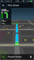
Karta GPS is a mobile application developed by Karta Software Technologies Lda a daughter company of NDrive for the Android and iOS operating systems. It is distributed for free and pairs open-source map data from OpenStreetMap alongside content from Yelp and Foursquare. The application does not require connection to Internet data (e.g. 3G, 4G, WiFi, etc.) and normally uses a GPS satellite connection to determine its location. Karta GPS provides traffic info from INRIX to plot the best route available based on real-time traffic information.
History
The application’s beta release was released on November 4, 2016.[1] In May 19, 2017, Karta GPS featured both Bill Clinton and Donald Trump’s voices in its selection of navigation voice overs.[2]
Features
Offline Maps and Guidance
All maps can be downloaded for free. No internet is required for searching, route calculation or turn-by-turn instructions.
Search
One box search supports partial names, initials and can search everything: points of interest, street names, crossing streets, GPS coordinates and address points.
Traffic
The application shows the route layered with different colours based on the current traffic along the route. Live traffic service finds faster routes and avoids traffic jams.
Suggestions
Curated point-of-interest content drawn from Yelp and Foursquare to Karta GPS maps (such as the ten best nearby restaurants, rather than 100 random ones), allows users to “explore” a location’s top rated places of entertainment, their descriptions, their last three reviews, photos of them, and their opening hours and prices.
Car & Walking
The application provides navigation for both car and walking.
Other features
- Safety cameras alert;
- Enriched OpenStreetMap (OSM) maps design;
- Simulate your drive to take a look at the route you'll be taking beforehand;
- Full voice guidance with spoken street names (TTS);
- Automatic rerouting as traffic conditions change on the road;
- One-box search;
- Voice search;
- Lane assistance for those complex highway exits;
- Several alternatives for each calculated route;
- Parking spot finder;
- Navigate to contact stored on the phone;
- Estimated time of arrival sharing.
