Key:carriageway_ref
 |
| Description |
|---|
| The carriageway reference used for maintenance and emergency services. |
| Group: references |
| Used on these elements |
| Requires |
|
| Useful combination |
| Status: de facto |
| Tools for this tag |
|
carriageway_ref is used to distinguish the two separated carriageways of a dual carriageway road. These markers allow emergency services and maintenance agencies to locate where incidents may be occurring, and people calling for breakdown services to locate themselves to their breakdown operator. This is very different from the ref=* tag, which is used to indicate the road number.
This key can be used on ways and nodes:
- use on
 highway=* for the carriageway reference of the road;
 - use on
 highway=milestone for the carriageway reference indicated on the highway location marker.
European use
 Belgium
In Belgium, for all numbered roads, traditionally a 3-digit carriageway identifier (Dutch: wegindex) is assigned to every link road, i.e. any carriageway other than the main carriageway(s).
This is indicated on the distance signs of these link roads in the so-called Ident7 notation. In this 7-character notation:
- the letter and first three digits indicate the road (tagged as ref=*, nat_ref=*, or official_ref=*, omitting dots and leading zeros, in special cases appended with an extra lowercase letter as described below), and
- the last three digits indicate the carriageway (tagged as carriageway_ref=*).
The underlying system is as follows:[1]
| Wegindex | Usage description | Tagging |
|---|---|---|
| 000 | Main carriageway(s) (Dutch: hoofdweg), typically not signed as Ident7 | Not tagged (unless carriageway_ref=h, h1, or h2 indicated on signs, see below) |
| 001 up to and including 499 | All sorts of link roads within junctions | Tagged as carriageway_ref=* |
| 500 up to and including 515 | Parallel carriageways (Dutch: langswegen) | |
| 520 up to and including 599 | Private service roads (Dutch: uitbatings- en dienstwegen) | |
| 901 up to and including 923 | Separate side roads with a modified road number (Dutch: geïndiceerde wegen) | The corresponding single lowercase letter suffix is appended to the road number in ref=*/nat_ref=*/official_ref=* |
| 924 up to and including 926 | Used on dual-carriageway roads where one carriageway is substantially longer (Dutch: asymmetrische wegen) | Tagged as carriageway_ref=* |
| 927 up to and including 939 | Parallel carriageways corresponding to separate side roads with a modified road number (Dutch: langswegen op geïndiceerde wegen) | Tagged as carriageway_ref=* and the corresponding single lowercase letter suffix is appended to the road number in ref=*/nat_ref=*/official_ref=* |

Ident2 notation: N462
Ident7 notation: N.462.000
ref=N462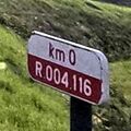
Ident2 notation: R4
Ident7 notation: R.004.116
ref=R4
carriageway_ref=116
Ident2 notation: N34a
Ident7 notation: N.034.901
ref=N34a


In Flanders, on regional roads (gewestwegen) of operator=Agentschap Wegen en Verkeer, the following carriageway indications are in use on modern distance signs:
- For the main carriageway of a single-carriageway road:
- carriageway_ref=h: main carriageway (hoofdweg, equivalent to wegindex 000)
- For the main carriageways of a dual-carriageway road:
- carriageway_ref=h1: main carriageway with ascending distance (hoofdweg 1, equivalent to ascending direction of wegindex 000)
- carriageway_ref=h2: main carriageway with descending distance (hoofdweg 2, equivalent to descending direction of wegindex 000)
- For ramps:
- carriageway_ref=a1: off-ramp with ascending distance (afrit 1)
- carriageway_ref=a2: off-ramp with descending distance (afrit 2)
- carriageway_ref=t1: on-ramp with ascending distance (toerit 1)
- carriageway_ref=t2: on-ramp with descending distance (toerit 2)
- For other link roads:
- carriageway_ref=v*: link (verbinding *)
Some motorways of operator=Bruxelles Mobilité - Brussel Mobiliteit in the Brussels-Capital Region have adopted the same scheme.

Ident2 notation: N46
Ident7 notation: N.046.000
ref=N46
carriageway_ref=h
Ident2 notation: A13
Ident7 notation: A.013.000
Ident8 notation: A.013.000.2
ref=E313;E34
int_ref=E 313;E 34
nat_ref=A13
carriageway_ref=h2


 France
The Boulevard Périphérique of Paris displays carriageway indications I and E on milestone signs in the central reservation:
- carriageway_ref=I: clockwise inner carriageway (intérieur, shown on a red sign: carriageway_ref:colour=red)
- carriageway_ref=E: counter-clockwise outer carriageway (extérieur, shown on a blue sign: carriageway_ref:colour=blue)
 Ireland
Ireland displays carriageway indications for the main carriageways of a dual-carriageway road:
- carriageway_ref=N: main carriageway in the northbound direction of the route
- carriageway_ref=E: main carriageway in the eastbound direction of the route
- carriageway_ref=S: main carriageway in the southbound direction of the route
- carriageway_ref=W: main carriageway in the westbound direction of the route
These are shown on location reference indicator signs, which look very similar to the driver location signs in the United Kingdom:

ref=M7
carriageway_ref=W
ref=N7
carriageway_ref=E
.svg)

 Netherlands
| Sign | Sign | Tag | Description |
|---|---|---|---|

|

|
carriageway_ref=Re | Right/forward main carriageway with ascending distance (hoofdrijbaan rechts). |

|

|
carriageway_ref=Li | Left/backward main carriageway with descending distance (hoofdrijbaan links). |

|

|
carriageway_ref=b | Link road or special situation indicated by a lowercase letter. Usually follows the letter assignment scheme from Beschrijvende Plaatsaanduidingsystematiek, e.g. b usually indicates an on-ramp to the right/forward direction. Sometimes mo is used on signs instead of m to avoid confusion with n, in these cases tag with carriageway_ref=mo. (What is a link road according to the road operator is not necessarily always a link road according to OpenStreetMap conventions, and vice versa.) |
The road number to which the carriageway reference corresponds, is tagged as ref=*, nat_ref=*, or official_ref=* (if multiple keys exist, the latter takes precedence). In some cases, an administrative road number is tagged with highway_authority_ref=*.
If the carriageway reference is not indicated on a sign, one may try to find it in a road operator database, e.g. Nationaal Wegenbestand. Older signs that omit the road number often also omit the Re/Li indications on the main carriageways.
In rare cases, bidirectional roads are assigned a different carriageway reference on each side. Use the keys carriageway_ref:right=* and carriageway_ref:left=* in these cases. Preferably reverse the way if needed to get the right/forward reference on the right side of the way (e.g. if you have carriageway_ref:left=Re, reverse the way so you get carriageway_ref:right=Re, which avoids a lot of confusion).
 United Kingdom
In the United Kingdom the main carriageways of a road are usually designated "A" and "B", with the off sliproad from the "A" side being "J" and the on sliproad being "K", with "L" and "M" being used for corresponding "B" carriageway sliproads. "C" and "D" are used for where motorways or other divided highways have collector/distributor lanes, e.g. the M20 near Maidstone or M60 around Manchester. Some more complicated junctions use other references.
The values are given on driver location signs signs and are also printed upon the emergency telephones (emergency=phone).
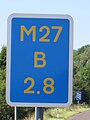
Example driver location sign for
ref=M27
carriageway_ref=B
Carriageway identifiers commonly used at junctions
