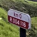
Tag:highway=milestone
| Description |
|---|
| Stone or metal marker on the side of a road indicating a reference and an approximation of the distance travelled. |
| Group: highways |
| Used on these elements |
| Useful combination |
|
| See also |
| Status: de facto |
| Tools for this tag |
|
A ![]() highway location marker is the modern-day equivalent of a milestone. Unlike traditional milestones, however, which were originally carved from stone and sited at exact one-mile intervals, modern highway location markers are made from a variety of materials and, in most countries, are spaced at intervals of a kilometre or a fraction thereof. These markers do vary in their accuracy to measure any distance as any established route usually varies over time, and most of the markers had been already placed, usually making the newly installed markers inaccurately positioned, compromising to the variants.
highway location marker is the modern-day equivalent of a milestone. Unlike traditional milestones, however, which were originally carved from stone and sited at exact one-mile intervals, modern highway location markers are made from a variety of materials and, in most countries, are spaced at intervals of a kilometre or a fraction thereof. These markers do vary in their accuracy to measure any distance as any established route usually varies over time, and most of the markers had been already placed, usually making the newly installed markers inaccurately positioned, compromising to the variants.
How to map
Draw the node ![]() where the milestone is, and add highway=milestone and other tags describing the sign.
where the milestone is, and add highway=milestone and other tags describing the sign.
Like traffic signs, the node can be placed either directly on the way that represents the road, or separately at the physical location of the sign besides the road. The pros and cons of both methods are similar to traffic signs.
These should be added to the relation of type=route that it refers to as having the Role ![]() milestone
milestone
Tagging
The following features are based on those described in the article Proposed features/Milestones. This tag has not been approved but is widely used.
| Key | Value | Description | Recommendation |
|---|---|---|---|
| highway | milestone | It's a highway milestone. The position of the node, member of highway way or in place is subject to discussion. | Mandatory |
| distance | <distance measure> |
A number being the distance from the beginning of the road. The real distance tends to vary over time as new road segments are either added or deleted from the original route. Decimal numbers specified with points are allowed. If no unit is explicitly given, the unit is assumed to be kilometres. To specify a different unit, add a space after the number, then the unit abbreviation (e.g., 35.0 mi). Another common method of expressing the marker's distance is by using a combination of kilometers and the meters that follow: (e.g., 45 + 5), in which case the 45 represents the kilometers and the 5 represents the meters. Although this method is mostly used in addresses for locations not found on the exact milestone. |
Optional |
| ref | <text> | A reference as written or present on the milestone. (Use unsigned_ref=*, otherwise.) | Optional |
| carriageway_ref + ref |
<text> | A carriageway reference as written or present on the milestone. Accompany with the highway reference in ref=* (preferably also as written or present on the milestone). | Optional |
| marker | <Milestone shape> | Visual shape of milestone, usually stone, plate, or post | Optional |
Similar tags
For "modern" milestones look at
For "historic" milestones look at
For utility markers look at
Examples
 Portugal
highway=milestone
distance=105
ref=EN 101
material=concrete
format=squared_stone
format:top=rounded


