Key:crossing:aircraft
Jump to navigation
Jump to search
| Description |
|---|
| Used to indicate how an aircraft impacts traffic at a aeroway=aircraft_crossing. |
| Group: crossings |
| Used on these elements |
| Useful combination |
| Status: approved |
| Tools for this tag |
|
The relative position of the aircraft to ground traffic can nearly always be deduced by the connecting ways on the node. (ie: intersecting node=ground/node on ground-based way=overhead)
In some cases it may be required to clarify the exact interaction between the aircraft and the ground-based way.
How to map
Use the tag on an aeroway=aircraft_crossing node. The node should be shared between the highway and aeroway.
| Tag | Possible Values | Comment | Diagram |
|---|---|---|---|
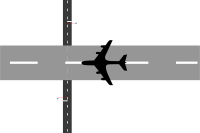
| crossing:aircraft=* | ground | (default) Aircraft crosses way while on the ground | 
|
| overhead | Aircraft crosses way while airborne overhead at a low altitude | 
| |
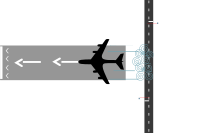
| exclusion_only | Aircraft does not directly cross the way, but the way is not navigable due to its movement nearby (ie, jet wash/unsafe clearance) | 
|
