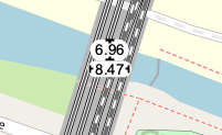
Key:seamark:bridge:clearance_height
Jump to navigation
Jump to search
| Description |
|---|
| The vertical clearance of the bridge (VERCLR). |
| Group: marine navigation |
| Used on these elements |
| Useful combination |
|
| Status: in use |
| Tools for this tag |
|
The vertical clearance of the bridge (VERCLR)
How to map
Add a node ![]() to waterway-line-object near the crossing of bridge and waterway. Please add
to waterway-line-object near the crossing of bridge and waterway. Please add
- seamark:type=bridge
- seamark:bridge:category=*
- seamark:bridge:clearance_height=* - height in meters
