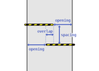
Key:spacing
| Description |
|---|
| Minimum distance between the grids of chicane shaped barriers like cycle barriers. |
| Group: restrictions |
| Used on these elements |
| Useful combination |
|
| Status: approved |
| Tools for this tag |
|
spacing=* indicates the distance between the elements of a multi-stage or chicane shaped barrier, like (motor) cycle barriers or kissing gates, to which the tag is added.
The value should be specified in metres (e.g. spacing=1.4) following the existing specification on tagging metric values like width values. If the distances between multiple barrier elements are different, only the smallest of these distances should be tagged since the smallest distance will determine the general passability (Example: If the first spacing on a triple-designed cycle barrier is 1.5 m and the second only 1.2 m, use spacing=1.2).
For simple types / designs of cycle barriers, simply specifying maxwidth:physical=* may be sufficient – see cycle_barrier=* for different designs and which tags should be combined.
opening=* and overlap=* could be a good addition.
See also
- barrier=cycle_barrier - A barrier along a path that slows or prevents access for bicycle users
- opening=* - Minimum opening or entrance/exit distance on chicane shaped barriers like cycle barriers
- overlap=* - Overlap distance of the barrier elements on multi-stage/chicane shaped barriers like cycle barriers
- maxwidth:physical=* - The maximum width available to pass a point in metres
- width=* - The width of a feature
