Key:turning_radius
Jump to navigation
Jump to search
| Description |
|---|
| to give the turning radius in a bend |
| Group: highways |
| Used on these elements |
| Status: undefined |
| Tools for this tag |
|
The tag turning_radius=number in meters is used to specify the radius of a bend. It is generally used for narrow carriage roads where trucks can circulate. This tag was created for the specific needs of logging. It is important to know the radius of the bends to see which vehicle can go on the forest roads (only truck, truck with trailer, truck for the long wood).
How to map
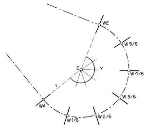
The radius of a bend is measured from the middle of the road to the center of the circle that forms the bend. This information can, in some cases, be consulted on build roads plans.
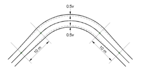
The tag turning_radius=number in meters can be combined with width=number in meters. In this case, it is used to indicate the extra width and the maximum width in the bend.


