Key:aeroway:weather_control
(Redirected from Key:weather control)
Jump to navigation
Jump to search
 |
| Description |
|---|
| Infrastructure for weather control. |
| Group: Weather |
| Used on these elements |
| See also |
| Status: proposed |
| Tools for this tag |
|
The key aeroway:weather_control=* is used to map an infrastructure from which a civilian vehicle is vertically launched (suborbital), e.g. for ![]() Cloud_seeding
Cloud_seeding
How to map
- Create a closed way around the extent of the launch pad area.
- Add the tag aeroway:weather_control=launchpad.
- Add rocket:launch=* anti_hail
Examples
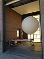
Weather balloon

Launch infrastructure

Launch infrastructure


LOADING TAG LIST...
See also
- monitoring:weather=* - To indicate a facility which monitors the weather
- balloon:launch=monitoring - Balloons for all kinds of monitoring (weather,air quality,radiation,traffic...)
- aeroway=launchpad - For spacecraft (rockets)
- aeroway=helipad - For helicopters
- military=launchpad - For missiles