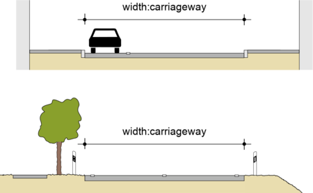
Key:width:carriageway
Jump to navigation
Jump to search
| Description |
|---|
| Width of the carriageway. |
| Group: highways |
| Used on these elements |
| Useful combination |
|
| See also |
|
width=* |
| Status: in use |
| Tools for this tag |
|
| This tagging can be considered obsolete since the definition of width=* on roads has narrowed to the same meaning. Therefore, width=* should be used instead. |
width:carriageway is a more explicit tagging to indicate the width=* of the carriageway, i.e. the width of the road from kerb to kerb or edge to edge. Parking lanes on the carriageway are included, but sidewalks/pavements and other road components beyond the kerb are not. This tagging can be considered obsolete since the definition of width=* on roads has narrowed to the same meaning.
For the specification of road widths, see also the chapter width of streets.

