Keypad-Mapper 3
- About
- an app to collect house numbers
- Impact on OpenStreetMap
- It was used a lot to collect house numbers.
- Reason for being historic
- no release since 2013, no further development
- Captured time
- 2021
|
Support for this app has been cancelled because of a dispute with the OSM community. |
| Keypad-Mapper 3 | ||||||||||||||||||||||||||||||||||||||||||||||||||||||||||||||||||||||||||||||||||||||||||||||||||||||||||||||||||||||||||||||||||||||||||||||||
|---|---|---|---|---|---|---|---|---|---|---|---|---|---|---|---|---|---|---|---|---|---|---|---|---|---|---|---|---|---|---|---|---|---|---|---|---|---|---|---|---|---|---|---|---|---|---|---|---|---|---|---|---|---|---|---|---|---|---|---|---|---|---|---|---|---|---|---|---|---|---|---|---|---|---|---|---|---|---|---|---|---|---|---|---|---|---|---|---|---|---|---|---|---|---|---|---|---|---|---|---|---|---|---|---|---|---|---|---|---|---|---|---|---|---|---|---|---|---|---|---|---|---|---|---|---|---|---|---|---|---|---|---|---|---|---|---|---|---|---|---|---|---|---|---|
| Authors: | NicRoets, Cobra, Markus59 | |||||||||||||||||||||||||||||||||||||||||||||||||||||||||||||||||||||||||||||||||||||||||||||||||||||||||||||||||||||||||||||||||||||||||||||||
| License: | BSD (free of charge) | |||||||||||||||||||||||||||||||||||||||||||||||||||||||||||||||||||||||||||||||||||||||||||||||||||||||||||||||||||||||||||||||||||||||||||||||
| Platform: | Android | |||||||||||||||||||||||||||||||||||||||||||||||||||||||||||||||||||||||||||||||||||||||||||||||||||||||||||||||||||||||||||||||||||||||||||||||
| Status: | Broken | |||||||||||||||||||||||||||||||||||||||||||||||||||||||||||||||||||||||||||||||||||||||||||||||||||||||||||||||||||||||||||||||||||||||||||||||
| Version: | 3.1.00 (2013-06-13) | |||||||||||||||||||||||||||||||||||||||||||||||||||||||||||||||||||||||||||||||||||||||||||||||||||||||||||||||||||||||||||||||||||||||||||||||
| Languages: | German, Greek, English, Spanish, French, Italian, Dutch, Polish, and Russian
| |||||||||||||||||||||||||||||||||||||||||||||||||||||||||||||||||||||||||||||||||||||||||||||||||||||||||||||||||||||||||||||||||||||||||||||||
| Website: | https://www.enaikoon.com/en/about-us/openstreetmap/ | |||||||||||||||||||||||||||||||||||||||||||||||||||||||||||||||||||||||||||||||||||||||||||||||||||||||||||||||||||||||||||||||||||||||||||||||
| Source code: | https://github.com/msemm/Keypad-Mapper-3 or 2018 fork with hungarian translation at https://github.com/meskobalazs/Keypad-Mapper-3 | |||||||||||||||||||||||||||||||||||||||||||||||||||||||||||||||||||||||||||||||||||||||||||||||||||||||||||||||||||||||||||||||||||||||||||||||
| Programming language: | Java | |||||||||||||||||||||||||||||||||||||||||||||||||||||||||||||||||||||||||||||||||||||||||||||||||||||||||||||||||||||||||||||||||||||||||||||||
|
highly efficient mapping of house numbers |
||||||||||||||||||||||||||||||||||||||||||||||||||||||||||||||||||||||||||||||||||||||||||||||||||||||||||||||||||||||||||||||||||||||||||||||||
| ||||||||||||||||||||||||||||||||||||||||||||||||||||||||||||||||||||||||||||||||||||||||||||||||||||||||||||||||||||||||||||||||||||||||||||||||
Keypad-Mapper 3 is an Android application dedicated to the rapid mapping of house numbers and address nodes.
This app is an enhanced version of KeypadMapper2, which is based on the original KeypadMapper published by Nic Roets in 2010. ENAiKOON would like to express their gratitude to Nic, who supported them during the implementation of the app's latest version with his ideas and patience.
|
The app scans current GPS position and GSM cell tower and contributes this information to the opensource project OpenCellID. |
Getting the Application
Keypad Mapper 3 is no longer available on Google Play Store since it hasn't been maintained or updated since 2013.
The best option is to download it directly for one of the forks, as these releases are from 2018 and not 2013 and therefore is more likely to work with recent devices.
Keypad Mapper
The other option is to download the application from F-droid. Since it hasn't been updated it is no longer in the main repository. You can find it in the archive repository or download it from the site.
Remember this release is from 2013 compared to the newer releases from the forked versions. In most cases this shouldn't make a difference but for some devices the newer forks may work better.
You can even get if from Amazon app store (although f-droid is probably better):
Quick start
- Find an area where house numbers are missing using OSM inspector.
- Use an app like OsmAnd for navigation and other features.
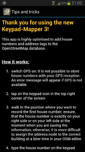
- Switch on GPS: it is only possible to save house numbers and address tags when there is a reliable GPS signal and position information, otherwise an error message will be shown.
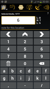
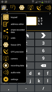
- Tap on the app icon in the top left corner and then on menu option 'keypad' or swipe to the keypad screen.
- Go to the position where you want to record a house number or an address node. Ensure that the house entrance is exactly to your right or to your left.
- otherwise it will be difficult later to assign the house number node to the correct building in the OSM editor.
- Type the house number on the keypad
- Save the house number by tapping on
 ,
,  ,
,  : the GPS coordinate is saved along with the address node which is actual at the moment the user taps on
  ,
,  ,
, 
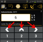
 means that the house number is on your left in relation to your walking direction.
 means that the house number is on your right in relation to your walking direction.
 means that the house number is in front of you in relation to your walking direction, e.g. at a T-crossing.
- In the upper left corner there is a counter for the house numbers you have mapped in the current mapping session.
- Repeat steps 5), 6) and 7) for each house number until all house numbers are recorded.
- When you are finished mapping house numbers, tap on the icon with the small house in the top left corner and then tap on 'settings'.
- In the settings screen you can find the option 'share recorded data' which allows you to send the recorded data as an email attachment to the computer used for the OSM editor (e.g. JOSM)
- Open the e-mail and save the attached files to your PC.
- Open the OSM editor and then open the .gpx file and the .osm file with the same name as well as the corresponding photos. Load the OSM data for the related area. You will see all recorded house numbers as well as the route taken while recording the data as well as an icon for each taken photo on top of the existing OSM data.
- Assign each house number to its respective building; look at the pictures and listen to the audio notes to remember all information available for optimizing the data.
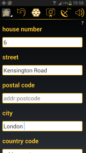
- Assign to each house number its street name, postal code, city name and country name (addr:street, addr:postcode, addr:city, addr:country)
- Upload the optimised and completed data to OSM
- Delete the recorded data on the phone / tablet with settings menu option 'delete all collected data' on the settings screen.
You will typically find the newly uploaded house numbers on the OSM map in the highest zoom levels some minutes after uploading them and after refreshing your browser window with the OSM map.
screen shots
OpenCellID
OpenCellID is an open-source project complementary to OSM.
The intention of this project is to collect GPS positions of GSM base stations. The data collected by the contributors of this project can be downloaded from OpenCellID under the terms of the Open Database license.
One of the main reasons for collecting OpenCellID data is that it can later be used for locating devices in areas where GPS reception is not available.
Keypad-Mapper 3 is a perfect application for collecting OpenCellID data while simultaneously collecting house numbers because Keypad-Mapper 3 users systematically walk down many different streets which guarantees optimal data for OpenCellID. Base stations along main roads can already be found in the database but base stations off the main streets are rare. This makes Keypad-Mapper a valuable source for CellID data. This feature cannot be switched off. Please use keypadmapper2 if you do not want to contribute to OpenCellID.
Reading the OpenCellID data from the GSM modem requires the permission 'to read phone state and identity'. The app does NOT use any other information of the phone state and identity except MCC, MNC, LAC, cellID, and signal-strength. The implementation of this feature ensures that the data is collected anonymously (see talk:Keypad-Mapper 3), ensuring full compliance with the very strict privacy laws in Germany. OpenCellID data is sent via the internet to the OpenCellID server immediately after they are collected. If the Wi-Fi only option is activated in the settings menu, the data is stored on the phone until a Wi-Fi connection is available.
tips and tricks for efficient mapping of house numbers
general
- house numbering on Wikipedia
- addresses in OSM
- tags for house numbers and addresses in OSM
- Karlsruhe Schema
- multiple addresses
- conscription numbers
- World bank: Street Addressing and the Management of Cities
- hints for mapping entrances
- house number contributors scoring list
- house numbers statistics
- discussion about best possible address tagging
JOSM
- Holding the SHIFT key while adding nodes lets you add many nodes rapidly without the need to terminate each way after adding the first node. This involves the use of your left hand.
- Holding the CTRL key while dragging a house number and dropping it near another node will merge the nodes. This involves the use of your left hand.
- video: address editor tool for JOSM
- Sometimes you got bad or no gps signal during tagging. This can result in clustered housenumbers and the house assignement is complicated. If you remember the sequence you tagged the questionable houses, the display of the tagging sequence of the housenumbers can help. The procedure is explained here.
- Plugins
- AddrInterpolation - JOSM plugin for creating interpolated addresses and for converting address interpolation ways to individual house numbers
- FixAddresses - JOSM Plugin providing a handy way to find incomplete or invalid addresses
- JOSM and house numbers
- HouseNumberTaggingTool: tool for easily adding address information to a node or way; can be found in JOSM menu section 'EDIT'
Potlatch 2
Potlatch2 cannot load .osm files (oh yes it can!). Therefore Potlatch is not suitable for processing Kepad-Mapper-3 data.
iD
not yet tested
addresses quality assurance tools
house number validator
incomplete addresses
addr:postcode areas Sorry, server is offline because on technical problems; sep 2013, wambacher
tools to find regions with missing addresses
source code
The source code is available at github
Changelog
new features version 3.1
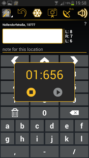
record voice note:
| Recording an audio note is less conspicuous to others than taking a photo, therefore some mappers prefer to record voice memos instead of taking GPS photos in order to avoid calling the attention of passerby. The audio note feature works similarly to the photo feature: it allows you to record a voice memo and save it along with a GPS coordinate. Unlike .jpg files, the GPS coordinates for audio notes are stored in the .gpx file, therefore the .gpx file must be loaded in JOSM before loading the .wav file.
The audio note entry in the .gpx file has the following content:
|
the RECORD button has been restored:
improved history:
the survey date is saved with each address tag:
See: Key:survey:date
Example:
- <node id="-1" visible="true" lat="52.497442495127025" lon="13.350499497003666">
- <tag k="survey:date" v="2013-06-01"/>
- <tag k="addr:housenumber" v="15"/>
- </node>
optimized screen layout for larger screens:
Some mappers are using 7" to 10" tablets for mapping. The relatively new Google Nexus 7 seems to be especially wide spread amongst mappers. This can be attributed to the fact that these devices have a longer battery life, allowing mappers to go on extended mapping tours without having to change the battery.
The new Keypad-Mapper version 3.1 provides a completely new user interface, optimised for tablet users in both landscape and portrait modes:
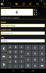
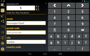
This UI is automatically activated on all devices with a minimum screen size of 7". Samsung Galaxy Note 1 and 2 are NOT using the tablet layout. Despite the fact that they are categorised as tablets the screen area available on these devices is not big enough for a proper tablet layout.
The tablet layout differentiates from the phone layout as follows:
- different sorting order of the icons in the menu bar:
the most important icons are as close to the position of the thumb as possible - more icons are shown in the menu bare compared to the phone layout
- the keypad screen and the address editor screen are both visible at the same time:
this gives a better overview of the currently configured / mapped data - the house number entry field is missing in the address editor screen
- in portrait mode, the keypad layout of the landscape mode for phone UI is used; this makes two-hand data entry possible
L/F/R and CLR on keypad screen replaced by icons:
L/F/R on keypad screen has been replaced by ![]() ,
, ![]() ,
, ![]() , 'CLR' has been replaced by
, 'CLR' has been replaced by ![]()
improved usability:
- a long tap on the house number entry field in the keypad screen opens a full keyboard for entering an unusual house number
- various readability improvements (e.g. bigger characters, better contrast, etc.) especially for mapping under direct sunlight
- improved response time of the app in case many house numbers were mapped
- in the address editor screen the house name entry field was moved to the bottom of the page
additional settings options:
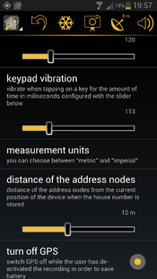
- turn off GPS:
allows you to optionally continue with the .gpx route recording even when the Keypad-Mapper 3 app is on in the background and/or while the screen is off - vibration on save:
defines the duration of the vibration in milliseconds when saving an address node (when tapping on ,
,  ,
,  )
) - keypad vibration:
defines the duration of the vibration in milliseconds when tapping on any key except ,
,  ,
,  on the keypad screen
 - use compass:
defines a speed up to which the compass information is used instead of the GPS heading information for calculating the direction - .WAV file path:
defines the .wav file path on your computer which will be used to save the recorded audio notes; this information is required by JOSM for proper loading of the .wav files
The sequence of the settings options on the settings screen has been optimized.
new in version 3.0
menu icon 'address editor':
| Tapping on this icon launches the address editor screen |
menu icon 'keypad screen':
| Tapping on this icon launches the screen for entering house numbers |
freeze GPS position:
There are other cases, like the situation shown in the pictures below, where the house number is hidden, making it necessary for you to pass the entrance and then look back for reading the house number:
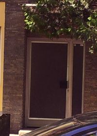
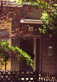
With the FREEZE option you can freeze the actual GPS position of the entrance (indicated by the highlighted freeze icon).
This allows you to go to the place where the house number is visible, enter the house number, and save it with the previously saved GPS position of the entrance.
After saving the house number by tapping on ![]() ,
, ![]() ,
, ![]() , the freeze mode is cancelled automatically and the freeze icon is no longer highlighted.
, the freeze mode is cancelled automatically and the freeze icon is no longer highlighted.
Another use case of the freeze GPS option is taking a photo with the GPS coordinates of the subject in the photo:
in this case, you can go to the place where the subject of the photo is located, use the freeze GPS option, and then relocate to take the picture of the subject.
This ensures that the GPS coordinates stored inside the JPEG file points to the position of the place and not to the position of the photographer.
take photos:
| The day-to-day experience of mapping house numbers has proven that GPS photos are useful for remembering complicated situations or additional information that has nothing to do with house numbers but is interesting enough to being mapped. In many cases, such photos save the mapper from entering additional text (e.g. for remembering a complete address printed on a menu, hints for special signs, etc.). The photo is taken with GPS information stored in the Exif meta data of the JPEG file. The photo can be uploaded along with the .gpx and .osm files to JOSM or to any other OSM editor and will be shown on the map where it was taken. |
optional text entry:
A separate field has been implemented for entering additional text, assigned to TAG key 'name'. While entering such additional text, a full keyboard is shown on top of the keypad with all required characters.
This is especially helpful when saving notes for future reference when optimising the data later in an OSM editor or if a house number must be mapped with characters different from the ones on the keypad.
The note is stored in the .osm file assigned to a TAG with type 'name'.
Example:
- <node id="-1" visible="true" lat="52.49750275564635" lon="13.35025888569893">
- <tag k="name" v="this is your additional text"/>
- <tag k="addr:housenumber" v="51"/>
- </node>
This information can be deleted with the OSM editor after using it or it can be assigned to the correct TAG type.
motivation:
The number shown in the circle of the app icon indicates the number of house numbers mapped that day.
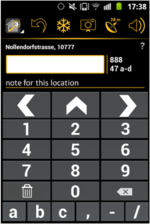
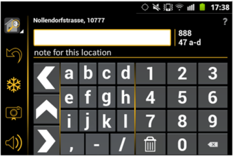
optimisation of the keypad screen for small devices:
Users of devices with small screens can hide several elements of the keypad screen:
- question mark for launching the help screen
- display of street name and postcode
- entry field for additional text
In addition fewer characters are shown on smaller screens.
In case that you are using a small screen, all characters are made available if you turn the device to landscape orientation:
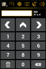
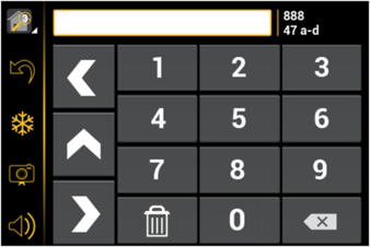
history:
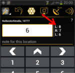
The last two or three stored house numbers are continuously shown on the right side of the house number entry field.
The amount of shown house numbers depends on the size of the screen.
undo:
| This option removes the most recently added house number from the .osm file. It is not possible to undo more than one previously recorded house number. |
display of current street name and postal code:
Current street name and postal code are shown based on NOMINATIM data (only visible if the device is online). This allows seeing if the data already stored in the OSM database is correct and complete and whether there are typos in the existing data.
connect to the internet via Wi-Fi only:
This option is especially helpful if your current GSM data plan is expensive or if the amount of free data is limited.
measurement units:
Both metric and imperial measurement units in metres and feet are supported for entering the distance between the current device position and the position of the address nodes. This allows the use of the software in countries with imperial measuring units.
keep screen on:
This option keeps the screen of the device on while mapping.
swipe from screen to screen:
The user has the choice to either tap on a menu item to open another screen or to swipe horizontally over the screen with one finger to get to another screen.
share recorded data:
delete all recorded data:
This option is normally used to free some space on the device as soon as the collected data has been successfully sent to the PC running the OSM editor.
detailed help text:
A detailed help text in all nine supported languages is available for a quick understanding of the app's main features.
nine languages:
- Dutch
- English
- French
- German
- Greek
- Italian
- Polish
- Russian
- Spanish
Special thanks to Stefano for the Italian translation as well as for the promotion of Keypad-Mapper 3 on talk-it
Additional thanks to Adam for the Polish translation and to Harry for the Dutch translation.
If you would like to translate the Keypad-Mapper 3 into another language, please contact User:Markus59.
resource editor integration:
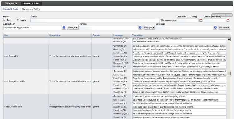
All text resources and graphics resources used by the app are maintained in the ENAiKOON resource editor.
This is a server-based web application.
Advantage: an additional language or any changes of some existing resources are immediately available for all users of the app without the need of updating the entire app.
crash reports:
In case the app crashes, there is an option to send a crash report with important information (e.g. a stack trace) to the Keypad-Mapper 3 developers.
This allows them to find and fix the bug in order to ensure the highest possible quality. No private data, including passwords, is sent to the developers.
only one version for all Android versions:
All Android versions from 2.1 to 4.x are supported.
app icon:
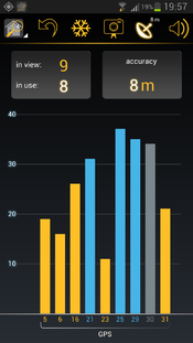
'GPS precision' screen:
The screen 'GPS precision' gives information about the current GPS reception.
| The GPS precision icon in the menu bar shows the GPS precision in metres or feet depending on the measurement unit settings. |
| If the compass of the device is used for calculating the direction, then a compass needle in the GPS icon is shown. |
| If the GPS precision icon in the menu bar shows no number, then there might be GPS reception, but quality is not good enough for the Keypad-Mapper. |
other great apps for mapping house numbers:
The main idea behind Keypad-Mapper 3 is to map house numbers, and eventually address nodes, as efficiently as possible for a seamless editing of data later at home with JOSM or any other OSM editor.
Many mappers feel that adding tags other than the house numbers while mapping is a waste of time and that it can be done more effectively and conveniently later at home.
Other OSM mappers prefer completing the data immediately while collecting it, including a precise position of the node on the map.
OSM mappers with this preference might prefer OsmPad.
OSM mappers that prefer not to specialize in house number mapping but would rather map multiple geo data at a given position may prefer the OSMtracker app.
feature requests
please see talk:Keypad-Mapper 3#wish list
at SOTM2013
During the SOTM 2013 OpenStreetMapconference in Birmingham Markus presented version 3.1 of the Keypad-Mapper 3. PDF slides of the presentation are available for download. The video is available at http://lanyrd.com/2013/sotm/scpkgq/
sponsoring
The development of Keypad-Mapper 3 has been sponsored by ENAiKOON GmbH.

