Ko:Tag:highway=toll_gantry
| 설명 |
|---|
| 흔히 '하이패스' 라고 불리며 해당 태그는 도로위에 있는 전자방식 자동결제 시스템입니다. |
| 그룹: 도로 |
| 해당 요소의 사용 |
| 같이 보기 |
| 상태:승인 |
| 이 태그를 위한 도구 |
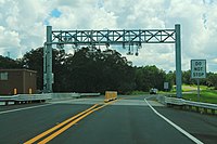
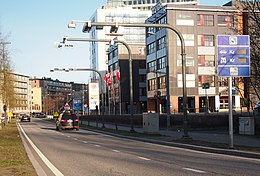
한국에서는'하이패스' 라고 흔히 불리며 우리가 아는 일반적으로 보는 물리적 장벽 또는 요금 징수 부스가 포함된 요금 징수에 대해서는 해당 태그를 참고하면 됩니다. barrier=toll_booth 보고있는 해당 태그에서는 고속도로와 같은 길 위에 매달린 갠트리 모양입니다. 갠트리에는 물리적 장벽이 없어야 하며 차량이 방해받지 않고 통과할 수 있어야 하지만 일부는 기계는 운전자가 속도를 줄여야 정상적으로 작동합니다. 경우에 따라서 모양새가 다른데 그 모양새는 아래 사진에서 확인 할 수 있습니다.
맵핑방법
Place a node on the way where the physical gantry crosses over the road and add the tag highway=toll_gantry. For a toll collection system appended to an existing bridge, add the node as close to the physical location of the system without adding the node to any ways on the bridge. Then add the tag highway=toll_gantry. The way that the node is placed on must also be tagged with toll=yes on any applicable road segments.
This should not be used in the case of the German toll enforcement gantries. For such cases, please refer to the enforcement relation page. More info can be found on the barrier=toll_booth page here and the Wikipedia article Toll Collect.
In the case of multiple gantry structures functioning as one unit only a single node is necessary, see the below picture.
Points that only collect in one direction should have a direction= tag added with the appropriate direction value relative to way segment direction(forward/backward).
Examples
See also
- man_made=gantry - Road portal
- barrier=toll_booth - A place where a road usage toll or fee is collected.
- toll=* - Toll roads charge money for some or all traffic.
- highway=* - The highway tag is the primary tag used for any kind of street or way.
- https://wiki.openstreetmap.org/wiki/Relation:enforcement#Tags A different system used for enforcing that a toll is paid is referenced here.


