Mexico Earthquake Drill 2015

Earthquake Drill 2015 in Mexico
Follow on [https://twitter.com/search?q=%23SimulacroMX&src=typd Twitter #SimulacroMX
This page is to coordinate mapping activities in response to the 'Simulacro Nacional' (National Earthquake Drill) happening in September 2015 (#SimulacroMX).
The Mexico Civil Protection Office coordinates a series of commemorative activities around the devastating earthquakes of 1985. In this sense, a national exercise of a high-impact earthquake will be held on September 19th.
Official reference: Official Programme of the Commemorative Activities for the Earthquakes of 1985.
Objective
Involve the OpenStreetMap community to coordinate an exercise with OSM communities from other countries during the Earthquake Drill as it is done generally for HOT activations. This exercise will bring many benefits to the whole community, such as local/remote capacity building, protocol validation, and raising awareness of the value of the OSM community work in such scenarios.
Logistics
Times are set to the Mexico City time zone (GMT -05:00)
Date: September 19th, 2015
Place (in-person): Zócalo in Mexico City.
Communications via forum.openstreetmap: To avoid cluttering mailing lists, we suggest to use the discussion thread in the Mexico's Forum
- Spanish http://forum.openstreetmap.org/viewtopic.php?id=40579]
- English http://forum.openstreetmap.org/viewtopic.php?pid=544751
Time: 09:00 - 13:45
Drill starting time: 11:30
Activities
Training
09:00 - 11:30
Workshops:
- OpenStreetMap intro
- Editing the map
- OSM for humanitarian operations
- Use of Mapillary to collect imagery
Drill and HOT Activation
11:30 - 13:30
We will use the forum and HOTOSM Tasking Manager to give updates about the exercise (See Logistics).
Closing
13:30 - 13:45
Document lessons learned and next steps in this Wiki.
Mapping activities
Mapping Priority
- Please choose from highest priority first
- Experienced mappers are also asked to participate in validating completed tasks. Information on validating can be found here
| Job No. | Priority | Location | What to map | Imagery Source | Task Mapping Status | Task Validation Status |
|---|---|---|---|---|---|---|
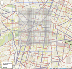
| #1202 - Mexico Earthquake Simulation Drill, Zócalo | Low | (Downtown) Cuauhtémoc, Mexico, DF | roads, buildings, open areas | Bing | In Progress | In Progress |
Remote mapping
Tasks will be distributed through the HOTOSM Tasking Manager.
Focusing on Infrastructure: Roads, major buildings, schools, names
Notes
When editing, add comment and specify the source of your information plus #SimulacroMX:
- Comment= Simulacro Nacional - National Earthquake Drill @OpenStreetMapMX #Mexico #SimulacroMX
- Source=Bing; #SimulacroMX2015
Field mapping
Cyclists and field mappers are invited to focus on identifying the following objects, to take Mapillary pictures and record infos :
- Tall buildings with number of floors: building, building:levels
- Schools: amenity=school, name
- Parks or large areas that could be used as shelters or camping sites: leisure=park, name
As a reference please see https://wiki.openstreetmap.org/wiki/Map_Features
Notes
Note that it is important to record the Name of important features.
When editing, add comment and specify the source of your information plus #SimulacroMX:
- Comment= Simulacro Nacional - National Earthquake Drill @OpenStreetMapMX #Mexico #SimulacroMX
- Source=GPS; #SimulacroMX2015
Tools for the job
- Mapillary for iOS and Android
- See this LearnOSM.org guide on Mapping with a Smartphone, GPS or Paper
Data Sources
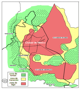
The map we used to set up the risk regions is based on pages 3 through 5 of the following document:
We've prepared a map in shapefile format to approximately match the one in the PDF link, due to the lack of data in open formats provided by the government.
Other Data Sources
Map and Data Services
About OpenStreetMap
OpenStreetMap offers an online map and spatial database that is updated by the minute. Various online maps are based on OpenStreetMap, including Navigation tools such as OSRM. Tools and services allow data extracts for GIS specialists, routable data for Garmin GPS, GPS navigation with smartphones and other device-compatible downloads. With an Internet connection, regular syncing is possible, because there is open access to the community-contributed data as it comes in. Also bulk with downloads of OpenStreetMap data are ideal for use offline. In addition, maps can be printed to paper, if needed.
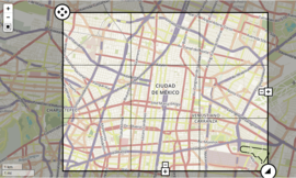
Browse the Activation Area to get a feel for the data that is currently available. Different map styles, including a special Humanitarian style, can be selected on the right side of the screen. Though some data may not render (appear) on the online map, it can be exported from the underlying database for other uses requiring more detail(See export section below).
Paper Maps
Large poster-size maps and letter-size paper atlases of custom areas can be printed:
- FieldPapers Paper Maps with grid for field survey or general navigation purposes,
- MapOSMatic Large Paper Maps with grid, street index and POI, good for command centers, hospitals, etc.
- Kathmandu Living Labs Quake Maps printable PDF extracts of major cities.
Exporting OpenStreetMap data
Frequent updates
There is more then one source for the same file format. This should assure a constant access to data if any problem arise from one host.
Information about the various OSM export formats
- OSM.pbf: These compressed OSM files are recognized by various GIS software.
- Shapefile: This data can be imported to GIS software, such as Quantum GIS or ESRI ArcGIS for Desktop.
- OSMAnd.OBF: OSMAnd / Android and iPhone Offline map and navigation. See LearnOSM.org tutorial on OSMAnd and Offline map navigation.
Educational resources
- Humanitarian Mapping - LearnOSM.org
- Mapping with a Smartphone, GPS or Paper - LearnOSM.org
- OSMAnd for offline map and navigation - LearnOSM.org
- OpenStreetMap Data - LearnOSM.org
How to join the effort
See Activities for more details.
- Infield mapping.
- Remote mapping using the HOTOSM Tasking Manager.
- Joining the training activities.
For in-person activities, please register clicking this link.
Lessons learned
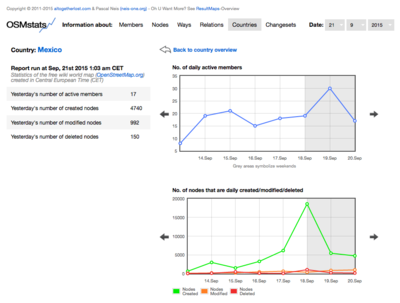
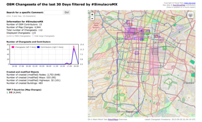
Collected by community members during the event.
- Offline ready. We had network issues during the event. Be prepared with paper maps, OSM dump, extra batteries.
- Who's mapping where in the field? Teams on the ground went together to map same streets. Field mapping should be planned by blocks, in the same way as remote operations using the Tasking Manager.
- Choose a meeting point. During the drill, we had challenges getting updates from government officials. You can't rely on messaging technology. An alternative could be defining time deltas or checkpoints to share updates.
- Save network banwidth. Although we had two Internet lines for approx. 15 people, network was too slow to work. We noticed that many connected devices (such as smartphones) were being used for other purposes such as social network updates. We might need to prioritize network usage. Allowed devices could function as data providers for offline devices.
- Define roles and interactions. During the drill we knew who had domain knowledge on specific topics, nevertheless we failed to define clear roles beforehand, thus taking time to get organized.
- Better satellite imagery. A must. Prepare to get fresh imagery before any exercise or drill. This will improve the experience for new mappers, and the quality of the contributions.
Ideas:
- Community discussion around shelter tagging (See: disaster:shelter_type).
- Find support for orthorectification processing.
- Use the Activation Template to set up a Wiki page quickly.
- Prepare customized map templates for different scenarios, such as the ones delivered by uMap and USGS during the Nepal activation.
- People new to OSM but with local knowledge could focus on leaving notes in the map, instead of full edits.
- Bicycles are suitable for transportation in highly populated areas. A bike team could be the first to map collapsed buildings and changes in the ground, before new imagery arrives.
