OSHDB
HeiGIT • Openrouteservice • Ohsome
Ohsome API • OSHDB • Ohsome Dashboard • OhsomeHeX • Ohsome quality analyst
The OSHDB is a high-performance data analysis framework for analysing OpenStreetMap's full-history data. Developed by the Big Spatial Data Analytics team at HeiGIT - Heidelberg Institute for Geoinformation Technology.
| OSHDB | ||||||||||||||||||||
|---|---|---|---|---|---|---|---|---|---|---|---|---|---|---|---|---|---|---|---|---|
| Author: | HeiGIT | |||||||||||||||||||
| License: | GNU LGPL v3 | |||||||||||||||||||
| Platform: | Java | |||||||||||||||||||
| Version: | 1.2.1 | |||||||||||||||||||
| Source code: | https://github.com/GIScience/oshdb | |||||||||||||||||||
| Programming language: | Java | |||||||||||||||||||
| ||||||||||||||||||||
General Information
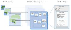
The OSHDB has been designed for efficient storage of and access to OpenStreetMap history data. In order to ensure the scalability of the system, it is build on a partitioning schema which allows distributed data storage and parallel execution of computations. The OSHDB API provides an interface to the OSHDB in the Java programming language. You can find the OSHDB on GitHub.
What can you do with the OSHDB API?
With the OSHDB API it is possible to use the map-reduce programming model to analyse the data in parallel.
You can
- specify a query region
- choose a query time span
- filter for OSM types and tags
- specify how to aggregate the data (for example by timestamp)
- map the result: generate a single result for each data object, or a (possibly empty) list of results for each data object and automatically flatten the results of several data objects into a single long list
- filter the result (for example only months with more than 5 unique users)
- reduce (aggregate) the results of the map phase across the whole compute cluster (for example count or sum)
In the following short example you see how to count monthly unique users, that edited highways of type way in the region of Heidelberg in a given time period.
OSHDBDatabase oshdb = new OSHDBH2("path/to/osm-history-extract.oshdb");
SortedMap<OSHDBTimestamp, Integer> numberOfUsersEditingHighways = OSMContributionView.on(oshdb)
    .areaOfInterest(OSHDBBoundingBox.bboxWgs84Coordinates(8.6319923, 49.3822610, 8.7327575, 49.4421242))
    .timestamps("2013-01-01", "2013-12-01", Interval.MONTHLY)
    .filter("type:way and highway=*")
    .map(contribution -> contribution.getContributorUserId())
    .aggregateByTimestamp()
    .countUniq();
| date | unique users |
|---|---|
| 2013-01-01T00:00:00Z | 27 |
| 2013-02-01T00:00:00Z | 13 |
| 2013-03-01T00:00:00Z | 14 |
| 2013-04-01T00:00:00Z | 18 |
| 2013-05-01T00:00:00Z | 26 |
| 2013-06-01T00:00:00Z | 25 |
| 2013-07-01T00:00:00Z | 18 |
| 2013-08-01T00:00:00Z | 15 |
| 2013-09-01T00:00:00Z | 12 |
| 2013-10-01T00:00:00Z | 18 |
| 2013-11-01T00:00:00Z | 21 |
For further examples go to this tutorial or view these blog posts.
Publications and Presentations
Papers related to the OSHDB:
- Raifer, Martin; Troilo, Rafael; Kowatsch, Fabian; Auer, Michael; Loos, Lukas; Marx, Sabrina; Przybill, Katharina; Fendrich, Sascha; Mocnik, Franz-Benjamin; Zipf, Alexander (2019): OSHDB: a framework for spatio-temporal analysis of OpenStreetMap history data. Open Geospatial Data, Software and Standards, https://doi.org/10.1186/s40965-019-0061-3.
- Auer, Michael; Eckle, Melanie; Fendrich, Sascha; Kowatsch, Fabian; Loos, Lukas; Marx, Sabrina; Raifer, Martin; Schott, Moritz; Troilo, Rafael; Zipf, Alexander (2018): Ohsome – eine Plattform zur Analyse raumzeitlicher Entwicklungen von OpenStreetMap-Daten für intrinsische Qualitätsbewertungen. AGIT ‒ Journal für Angewandte Geoinformatik.
- Auer, Michael; Eckle, Melanie; Fendrich, Sascha; Griesbaum, Luisa; Kowatsch, Fabian; Marx, Sabrina; Raifer, Martin; Schott, Moritz; Troilo, Rafael; Zipf, Alexander (2018): Towards Using the Potential of OpenStreetMap History for Disaster Activation Monitoring. Proceedings of the 15th ISCRAM Conference – Rochester, NY, USA May 2018.
State of the Map talks about the OSHDB:
- 2018: Michael Auer, Melanie Eckle, Sascha Fendrich, Fabian Kowatsch, Sabrina Marx, Martin Raifer, Moritz Schott, Rafael Troilo, Alexander Zipf: Comprehensive OpenStreetMap History Data Analyses- for and with the OSM community.
- 2017: Martin Raifer: OSM history analysis using big data technology.


