OSMGarminMap
| OSMGarminMap has not been updated to work with API 0.5 files. We recommend you use the Mkgmap program instead which works with API 0.5 files and is faster and easier to use. Alternatively, osm2mp is an updated convert to polish format.
There is also a general overview page at OSM Map On Garmin. |
This program will convert OpenStreetMap .osm-Files into maps that can be loaded into Garmin GPS devices.
It supports showing nodes, segments, ways and areas using Garmin icons etc.
You will need xsltproc. Here are details on how to get xsltproc
You will also need the "cGPSmapper" program and its companion "sendmap". These programs are not Open Source but there is a free version for personal use which you can download from http://www.cgpsmapper.com/ .
You can then download OSMGarminMap from Subversion.
OSMGarminMap was created by Jochen Topf <jochen@remote.org>.
See OSM Map On Garmin for other programs doing similar stuff.
Creating a map
Download some data from OpenStreetMap Server and save it into a file called "data.osm". You can then call "make" and it will generate the Garmin map file in several steps. The makefile uses xsltproc, but it is easy to change to use other XSLT engines. You also have to change the location of the cGPSmapper program in the Makefile.
If there is a problem or you want to know about the details, here is a step-by-step description:
1. OSM -> MPX: In the first step this data will be converted from the OSM XML format into an XML format that is much nearer to the format that Garmin devices can understand. Mapping from the OSM format to the Garmin format you have to decide which OSM features should be mapped to which Garmin features. To describe this process, you can change the osm2mpx.xml File. It uses the same rules as Osmarender uses. In fact I "stole" some of the Osmarender code for this.
xsltproc osm2mpx.xml >map.mpx
2. MPX -> MP: The second step will convert this XML format to a legacy format called the Polish format which can then be read by cGPSmapper. This is where the symbolic names in the .mpx file will get translated into hex codes.
xsltproc feature-list.xml >map.mp
3. MP -> IMG: This file can then be read by cGPSmapper, which will create a .img file.
cgpsmapper-static map.mp
This will take a moment. You'll see some output from cGPSmapper ending with:
   Done!
   File :map.img is ready to use
Transferring map to GPS unit
Now you can take this file and transfer it to your GPS unit using the sendmap program which is also available from the cGPSmapper website.
sendmap20 map.img
You might need to use some options depending on where your GPS unit is attached (serial port/USB). You might need to be root. Call sendmap without any parameters to get help.
Devices
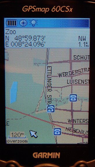
This was tested on my Garmin GPSmap 60CSx. Works well except the zooming stuff (see below).
On the Garmin Vista Cx, sendmap is unnecessary - copy map.img to /Garmin/gmapsupp.img on the micro-SD card, either plugging the unit in via USB or separately in a card reader device. Zooming does appear to work on this device, but not all roads appear to render (highway=tertiary in particular). This can be fixed by editing osm2mpx.xml & adding tertiary with secondary.
Please add infos about your experiences with OSMGarminMap here.
Map features
The list of map features is created from the OpenOffice spreadsheet file called feature-list.ods. To change anything, change this spreadsheet file, save as CSV with the vertical bar (|) as field delimiter and no text delimiter. Then run the feature-list-csv2xml.pl file like this:
./feature-list-csv2xml.pl feature-list.csv >feature-list.xml
Known issues
- The list of map features that Garmin offers is not complete. The list was created from some incomplete stuff I found on the web. If you find any other code for other features please tell me.
- Currently the conversion of OSM features into Garmin features is very basic. The usual highways are included as well as parks and forests and some amenities like parking lots and telephones. I welcome any additions.
- In theory cGPSmapper can create and Garmin units can use maps in a way that some features are only visible when zoomed in far enough. When zooming out, those features will not be omitted to reduce clutter. For some reason I could not get this to work.
- Ways will be put into the Garmin map not one segment at a time, but as a complete way. If the segments are not ordered properly along the way (something which can easily happen in OSM when adding new segments to a way) you'll get spurious segments zigzaggin around the map. I'll probably not fix this in OSMGarminMap, because it should be fixed in the database itself. That way the fix will help everybody, regardless in which way they are using the data.
