OSM and OSL differences analysis
When Ito World first started delivering tools for OpenStreetMap (OSM), there were very few options on the market. Since that time, many new tools and companies have focused on serving the OSM community. As a result, Ito World has decided to withdraw its OpenStreetMap Tools.
We’d like to take this opportunity to thank everyone who has used these tools over the past 8 years and would like to encourage everyone to keep contributing to OSM.
Alternative services you may wish to look at include https://www.geofabrik.de and https://www.mapbox.com. For more information about OSM data, please visit https://learnosm.org/en/ or https://wiki.openstreetmap.org/.
| OSM Analysis | ||||||||||||||||||||||||||||||||||||
|---|---|---|---|---|---|---|---|---|---|---|---|---|---|---|---|---|---|---|---|---|---|---|---|---|---|---|---|---|---|---|---|---|---|---|---|---|
| Author: | ITO World | |||||||||||||||||||||||||||||||||||
| License: | (free of charge) | |||||||||||||||||||||||||||||||||||
| Platform: | Web | |||||||||||||||||||||||||||||||||||
| Status: | Broken | |||||||||||||||||||||||||||||||||||
| Version: | (2013-12-05) | |||||||||||||||||||||||||||||||||||
| Language: | English
| |||||||||||||||||||||||||||||||||||
| Website: | ||||||||||||||||||||||||||||||||||||
|
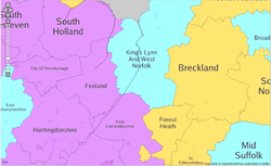
Screenshot of OSM Analysis tool, East of England. |
||||||||||||||||||||||||||||||||||||
| ||||||||||||||||||||||||||||||||||||
The OSM and OSL differences analysis (http://product.itoworld.com/product/data/osm_analysis/main) by ITO World provided various road name completeness measuring statistics for England, Wales and Scotland by comparing road names in OpenStreetMap with those released by the Ordnance Survey in their OS Locator dataset. These were broken down by district/borough and thematic and trend and slippery map views.
Functionality
The service allowed these 408 districts/boroughs to be ranked in order of road name completeness, and highlighted differences between then two datasets visually on a slippery map. A coloured thematic map view is also available and a summary page for each district/borough. The OSM and OSL differences tileset used by this service is also available separately and can be accessed from within the iD, Potlatch and JOSM editors.
Street name differences of a single apostrophe are classed as minor errors in the summary page and shown in grey on the map tiles.
Tagging within OpenStreetMap
|
OS Locator contains errors. Where a road is already named in OpenStreetMap, please do not just change it to match a different name in OS Locator without strong evidence that the OSM contributor was wrong! |
See Interpreting the differences for guidelines on using OS Locator data.
- For roads where there is no name in OSM and where a plausible name is available from OS Locator then it is common practice to add it to OSM based on OS data.
- Where the name in OSM is clearly incorrect, this can be corrected in the usual way (examples typos, common misspelling of names or local names, and information provided against the wrong tag). By way of example, 'High Stret' and 'High Stree' (which are almost certainly simple misspellings), William Wodsworth Avenue (almost certainly a typo, especially in a area where all roads are named after poets or some other relevant category),30 mph (value should be in maxspeed), B1333 (value should be in ref).
- Where OS Locator provides a valid alternative name for a road then place the most common name, often the one shown on a street sign, in name=* and the less common one in alt_name=*.
- Where OS Locator is obviously wrong, the value can be put straight in not:name (typos as for OSM above - less common but they do happen, including using '1' (one) in place of 'i' (lower case I)' which look the same in capitals in some fonts.
- Where there is no road to which to add the name, then using Bing imagery or OS Streetview as a reference for the geometry
- If the name in OS Locator does not match with the name on the street, or with any other official source, then tag this using not:name=* tag. Extra information about why the name is wrong can be provided in the not:name:note=*. This check will stop the difference being flagged as a mismatch, and will list it on the district/borough summary page as a mistake in the OS data. The Ordnance Survey are aware of this service and can use it as part of these data quality feedback mechanism. These not:name and not:name:note fields can be deleted when they have been corrected in the latest OS Locator data.
- If a name is given in OS Locator for a street that doesn't exist or no longer exists then a way (which will not be rendered) can be added to OpenStreetMap tagged as highway=no, the relevant not:name=*, and any notes.
- Consider using note=* name:note=* to given more information about why the name used is correct where this may not be obvious to avoid others 'correcting' the value back to the more obvious, but wrong, value.
Currently only ASCII, as opposed to Unicode, apostrophes will not be flagged as an error. This is not necessarily OpenStreetMap tagging policy.
History
The service was introduced in July 2010 with an an announcement on the ITO World blog.
The service stopped being available in September 2019 as the OS data stopped releasing the OS Locator data some years ago. Announcement.
