Seamarks/Bridges
< Seamarks(Redirected from OpenSeaMap/Bridges)
Jump to navigation
Jump to search
Seamark tagging
Bridges
The tags defined on this page will render in various nautical charts (zoom-level 16 and higher).
An other example: Navigable Waterways, Europe (zoom-levels 1-13)
For routing purpose, the tag should be placed on the waterway beneath the bridge.
This page defines tags for the attributes of bridges.
| Type | S100 code | seamark:type | Definition |
|---|---|---|---|
| Bridge | BRIDGE | bridge | A structure erected over a body of water to provide a roadway for vehicles, pedestrians or to carry utility services. |
Categories
| Category (CATBRG) | seamark:bridge:category | Note | Definition | Photo |
|---|---|---|---|---|
| Fixed bridge | fixed | preferred category. If known, add seamark:bridge:clearance_height=* | A bridge having permanent horizontal and vertical alignment. | |
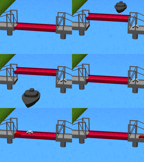
| Opening bridge | opening | preferred category. If known, add seamark:bridge:clearance_height_closed=* | A bridge that is closed when set for carrying road traffic and open when set to permit marine traffic to pass through the waterway it crosses. | |
| Lifting bridge | lifting | preferred category. If known, add seamark:bridge:clearance_height_closed=* and seamark:bridge:clearance_height_open=* | A movable bridge (or span thereof) which is capable of being lifted vertically to allow vessels to pass beneath. | 
|
| Swing bridge | swing | opening, if known, add seamark:bridge:clearance_height_closed=* | A movable bridge (or span thereof) which rotates in a horizontal plane about a vertical pivot to allow the passage of vessels. | 
|
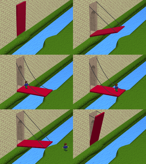
| Bascule bridge | bascule | opening, if known, add seamark:bridge:clearance_height_closed=* | A counterpoise bridge rotated in a vertical plane about an axis at one or both ends. | 
|
| Pontoon bridge | pontoon | ambiguous: might be fixed or opening | A fixed floating bridge supported by pontoons. | |
| Drawbridge | drawbridge | opening, if known, add seamark:bridge:clearance_height_closed=* | A general name for bridges of which part or the entire span of the bridge may be raised or drawn aside to allow ships to pass through. | 
|
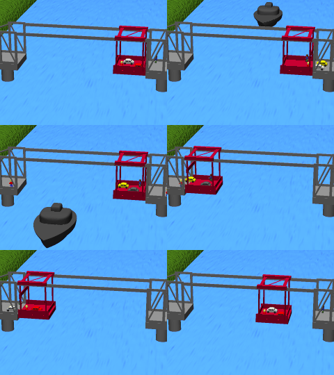
| Transporter bridge | fixed, if known, add seamark:bridge:clearance_height=* | A bridge that has towers on each side of the waterway connected by a girder system on which a carriage runs. | 
| |
| Foot bridge | footbridge | ambiguous: might be fixed, opening, lifting | A bridge structure used only for pedestrian traffic. | |
| Viaduct | viaduct | fixed, if known, add seamark:bridge:clearance_height=* | A long bridge consisting of a series of beams, spans or girders (of steel, timber or concrete) supported on towers or piers and used to carry a road, railroad, etc. | |
| Aqueduct | aqueduct | fixed, if known, add seamark:bridge:clearance_height=* | A bridge supporting an artificially elevated channel, for the conveyance of water. | |
| Suspension bridge | suspension | ambiguous: might be fixed or lifting | A fixed bridge consisting of either a roadway or a truss suspended from two or more cables which pass over towers and are anchored by backstays to a firm foundation. | 
|
Clearances
| Attribute | seamark:bridge:<attribute> | Value type | Definition |
|---|---|---|---|
| Horizontal clearance (HORCLR) | seamark:bridge:clearance_width=* | Decimal | The width that is available for safe navigation. |
| Vertical clearance (VERCLR) | seamark:bridge:clearance_height=* | Decimal | The vertical clearance measured from the surface plane towards the object overhead. |
| Vertical clearance, closed (VERCCL) | seamark:bridge:clearance_height_closed=* | Decimal | The vertical clearance the bridge in closed condition measured from the surface plane towards the object overhead. |
| Vertical clearance, open (VERCOP) | seamark:bridge:clearance_height_open=* | Decimal | The vertical clearance of the bridge in opened condition measured from the surface plane towards the object overhead. |
Tools
- JOSM preset seamark:type=bridge/gate
- JOSM style european-waterways-classification
- JOSM style INT 1 Rendering (IHO standarized symbols) PD
See also
- bridge=* - bridges for normal mapping
References
OSM seamark resources
- Seamark tag values(en)
- Seamark objects(en)
- Seamark attributes(en)
- Categories of objects(en)
- INT-1 cross reference(en)
- Inland waterway notice marks (CEVNI, Europe)(en)
- Inland waterway lateral marks (CEVNI, Europe)(en)
- Inland waterway notice marks (BNIWR, Brazil)(en)
- Inland waterway notice marks (PPWBC, Brazil/Paraguay)(en)
- Inland waterway notice marks (RIWR, Russia)(en)
JOSM presets & styles
External sources
- S-101 ENC/iENC registry (iho.int), the ENC Data Classification and Encoding Guide (DCEG) can be downloaded as zipped PDF, online access to symbols in Portrayal Register
- International nautical chart symbol legend (Chart INT-1, NOAA)
- Encoding Guide for Inland ENCs (openecdis.org, 2018), an international standard of the Inland ENC Harmonization Group is currently in development (IEHG Publication S-401, 2019)
- European Code for Inland Waterways (CEVNI), (UNECE, Fifth revised version 2015)
- European Code for Signs and Signals on Inland Waterways (SIGNI), (UNECE Resolution N0. 90, 2018)
- U.S. Aids to Navigation System – also details the Western Waters Marking System, Intracoastal Waterway system, and Uniform State Waterway Marking System