Tag:man_made=pipeline
| Description |
|---|
| A major pipeline carrying gas, water, oil, etc. |
| Group: pipelines |
| Used on these elements |
| Useful combination |
| Status: approved |
| Tools for this tag |
|
The pipeline key is used for major pipelines carrying liquids, gases or slurry. The pipeline may be above ground, under water or underground. Common types include gas, water, oil, slurry (mineral ore), sewage.
How to map
Draw the way of the pipeline and add man_made=pipeline. Post markers can be used to determine the location of the pipe. They often have other information too, like the diameter and the operator of the pipeline.
Tags used in combination
| Tag | Value | Description | Recommendation |
|---|---|---|---|
| man_made=* | pipeline | It's a pipeline | mandatory |
| location=* | Pipeline's location. Combine with layer=* if applicable. | recommended | |
| substance=* | The substance transported within the pipeline. If the medium is not known, do NOT specify this tag. | recommended | |
| operator=* | <Company name> | Name of the company who is in charge of operating the pipeline | optional |
| usage=* |
transmission
distribution |
Closer classification of the network this pipeline belongs to. | optional |
| name=* | Official name of the pipeline | optional | |
| ref=* | Use this tag to specify a short, unique identifier for the pipeline. This value is used to logically link pipelines and markers together. Usually, marker plates already contain such a unique identifier. | optional | |
| diameter=* | The nominal diameter of the pipeline, in millimeters. | optional | |
| pressure=* | The nominal pressure of the pipeline, in bar. | optional | |
| capacity=* | The capacity of the pipeline. free text, only for information, since the unit commonly used usually depends on the medium. I.e., barrels/day, m³/h, l/s. | optional | |
| flow_direction=* | forward/backward/both | Use both to indicate that the medium within the pipeline may flow in both directions (loop configuration). use forward if the flow is in the direction of the pipeline way, backward otherwise. | optional |
| count=* | By design, some media require a pair (or more) of parallel pipelines; i.e., forward and return flow for heat pipelines. This tag specifies the number of pipelines running in parallel. Use this tag only if all pipelines run in parallel and have the same properties, like e.g. diameter. Otherwise, draw a separate way for each pipeline. | optional | |
| inspection_gauge=* | yes | if the pipeline features a sender or receiver for an inspection gauge, use this tag on the section of the pipeline way where the sender/receiver is located. | optional |
| place:origin=* | Specifies the place=* (town, city, ...) where the pipeline begins. If applicable, use the name as specified in the place=*'s name=* tag. | optional | |
| place:destination=* | Specifies the place where the pipeline ends. | optional |
Locations
| Key | Value | Description |
|---|---|---|
| location | underground | For pipelines under ground, not visible on the surface. |
| overground | For pipelines over ground, located close to the surface, not allowing a person or vehicle to pass underneath. | |
| overhead | For pipelines over ground, located at a height allowing persons or vehicles to pass underneath. use other tags like maxheight=* on the road underneath if applicable. Where the overhead pipeline might affect commercial shipping (crossing a navigational canal or river), consider the use of seamark:type=pipeline_overhead. | |
| underwater | For pipelines running below the surface of land-based bodies of water, like lakes or rivers. For pipelines at sea, use the Seamark tagging scheme. |
Usage
Rendering in openstreetmap-carto
| Drawing | Description | Tags (Wiki pages) |
|---|---|---|

|
Overground pipeline | man_made=pipeline location=overground / overhead |

|
Overground gas pipeline | man_made=pipeline location=overground / overhead substance=gas |

|
Overground oil pipeline | man_made=pipeline location=overground / overhead substance=oil |

|
Overground water pipeline | man_made=pipeline location=overground / overhead substance=water |
Pipelines at sea
Use the seamark tagging scheme for pipelines and installations at sea (over or under water), especially the CATPIP related ones. The transition between the OSM standard and the seamark schemes takes place where the pipeline enters / leaves the sea.
This is also applicable for pipeline installations on land, which may affect commercial shipping (i.e., pipelines over canals, etc.)
Related features
![]() the following tags can be used on nodes of the pipeline:
the following tags can be used on nodes of the pipeline:
- pipeline=valve describes a valve (see below)
- pipeline=measurement describes a measuring device (measuring point)
- depth=* the vertical distance from the pipeline to the surface of the ground or sea, in meters.
- inlet=* defines how a fluid enters in a given pipeline.
- outlet=* defines how a pipeline ends and release its content into open air environment.
![]() the following features shouldn't be used on nodes of the pipeline:
the following features shouldn't be used on nodes of the pipeline:
- marker=* since markers aren't properly part of the pipeline nor of its operational process. Furthermore position=* can give indication on how far the marker is from the pipeline. Then it's more accurate to place a separate node that isn't part of the pipeline.
Examples
| Photo | Tags | Note |
|---|---|---|

|
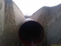
man_made=pipeline substance=gas name=West 4 E1-VL Sektion 2 ref=4W 020000 diameter=800 pressure=120 place:origin=Auersthal place:destination=Amstetten construction=yes usage=transmission |
(temporary) open end of the W4 pipeline during construction. already underground, but not yet buried. |

|
man_made=pipeline substance=oil name=Trans Alaska Pipeline ref=TAP diameter=1220 pressure=81.4 usage=transmission location=overground |
Trans Alaska Pipeline |