JA:Tag:man_made=pipeline
Jump to navigation
Jump to search
| 説明 |
|---|
| ガス、水、石油などを運ぶ主要なパイプラインです。 |
| グループ: パイプライン |
| 適用できる要素 |
| よく併用されるタグ |
| 状態:承認 |
| ツール |
この記事は翻訳記事ですが、翻訳が不完全であり、抜けや誤り、未翻訳の部分があります。
英語版の記事の内容が分かる方は、翻訳の完成にご協力ください。このウィキの翻訳方法についての説明をお読みください。
現時点では、誰もこの記事の翻訳に取り組んでいないようですので、あなたが取り組めます。
英語版の記事の内容が分かる方は、翻訳の完成にご協力ください。このウィキの翻訳方法についての説明をお読みください。
現時点では、誰もこの記事の翻訳に取り組んでいないようですので、あなたが取り組めます。
pipeline キーは液体、気体、泥状の物質を運ぶために使われる主要なパイプラインに使います。パイプラインは地上にあったり、水中にあったり、地下にあったりすることがります。よくある種類にはガス、水、石油、泥漿(鉱物)、汚水などがあります。
パイプライン
![]() 以下のようなタグが man_made=pipeline と組み合わせて使用されます。:
以下のようなタグが man_made=pipeline と組み合わせて使用されます。:
- name=* パイプラインの公式な名称です。
- ref=* パイプラインに割り振られた短い識別子です。この値はパイプラインと標識を結びつけるものです。通常、標識にはこれらの識別子が書かれています。
- location=* パイプラインの設置位置です:
| キー | 値 | 説明 |
|---|---|---|
| location | underground | 地表から見えない地下に設置されたパイプラインです。 |
| overground | 地表にあり、その下を人や車両が通れないような低い場所に接地されたパイプラインです。 | |
| overhead | 地上の、その下を人や車両が通れるような高いところに設置されたパイプラインです。可能ならば maxheight=*などのタグも併記します。高所に設置されたパイプラインが船舶の通行に影響する可能性がある場合 (運河や河川にかかっている場合など)、seamark:type=pipeline_overhead の使用も検討してください。 | |
| underwater | 湖や河川など、陸地にある水域の水面下に設置されたパイプラインです。海に設置されたパイプラインの場合は、 Seamark のタグスキームを使用してください。 |
combine with layer=* if applicable.
- diameter=* specifies the nominal diameter of the pipeline, in millimeters.
- pressure=* specifies the nominal pressure within the pipeline, in bar.
- count=* By design, some media require a pair (or more) of parallel pipelines, i.e. forward and return flow for heat pipelines. This tag specifies the number of pipelines running in parallel. Use this tag only if all pipelines run in parallel and have the same properties, like e.g. diameter. Otherwise, draw a separate way for each pipeline.
- inspection_gauge=yes if the pipeline features a sender or receiver for an inspection gauge, use this tag on the section of the pipeline way where the sender/receiver is located.
- place:origin=* specifies the place=* (town, city, ...) where the pipeline begins. If applicable, use the name as specified in the place=*'s name=* tag.
- place:destination=* specifies the place where the pipeline ends.
- capacity=* specifies the capacity of the pipeline. free text, only for information, since the unit commonly used usually depends on the medium. i.e. barrels/day, m³/h, l/s
- flow_direction=forward/backward/both use both to indicate that the medium within the pipeline may flow in both directions (loop configuration). use forward if the flow is in the direction of the pipeline way, backward otherwise.
- substance=* the substance transported within the pipeline. If the medium is not known, do NOT specify this tag. (this tag replaces the former type=* tag).
- usage=* closer classification of the network this pipeline belongs to:
使用方法
| キー | 値 | 説明 |
|---|---|---|
| usage | flowline | pipelines delivering the medium from the well in the ground to the nearest field gathering station substation=field_gathering |
| gathering | pipelines transporting the medium from gathering stations to the central processing station substation=central_processing | |
| injection | pipelines on oil & gas fields used to pump gas or water down the well to increase reservoir pressure | |
| flare_header | pipelines transporting gas to a flare stack | |
| export | pipelines transporting the medium from a field's central processing station to a pumping / compressor station along the main transmission network. | |
| transmission | pipelines, usually of large diameter and high pressure, transporting the medium over long distances. | |
| facility | pipeline network within a refinery or surrounding a compressor station or part of some other industrial facility | |
| distribution | network of pipes delivering the medium (usually from a substation=distribution) to customers (i.e. households), usually in municipalities | |
| penstock | pipe delivering water from a reservoir to turbines of a hydroelectric power plant |
![]() the following tags can be used on nodes of the pipeline:
the following tags can be used on nodes of the pipeline:
- pipeline=marker if the marker plate contains no position=* information, it is assumed that it is positioned directly above the pipeline. in this case, tag the appropriate node on the pipeline as pipeline=marker (see below)
- pipeline=measurement describes a measuring device (measuring point)
- depth=* the vertical distance from the pipeline to the surface of the ground or sea, in meters.
海のパイプライン
use the Seamark tagging scheme for pipelines and installations at sea (over or under water), especially the CATPIP related ones. The transition between the OSM standard and the Seamark schemes takes place where the pipeline enters / leaves the sea.
This is also applicable for pipeline installations on land, which may affect commercial shipping (i.e. pipelines over canals etc.)
関連する地物
| 写真 | 主タグ | 説明 |
|---|---|---|
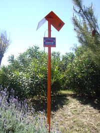
|
pipeline=marker | Marker indicating the path of an underground pipeline, mounted on poles, walls, pedestals etc. With different covers and colours. |
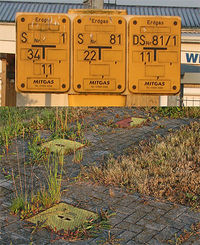
|
pipeline=valve | Valves are elements located on pipelines to control the flow of the medium. |
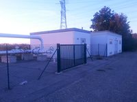
|
pipeline=substation | Facilities required for pipeline operation. |
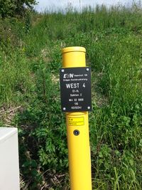
|
measurement=* | Measurements taken in from pipelines. |
| man_made=flare | 余ったガスを燃え尽きさせるために建設された塔です。 |
例
| 写真 | タグ | 備考 |
|---|---|---|
|
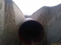
man_made=pipeline substance=gas name=West 4 E1-VL Sektion 2 ref=4W 020000 diameter=800 pressure=120 place:origin=Auersthal place:destination=Amstetten construction=yes usage=transmission |
(temporary) open end of the W4 pipeline during construction. already underground, but not yet buried. |

|
man_made=pipeline substance=oil name=Trans Alaska Pipeline ref=TAP diameter=1220 pressure=81.4 usage=transmission location=overground |
Trans Alaska Pipeline |