Proposal:Key:is sidepath:of
| is_sidepath | |
|---|---|
| Proposal status: | Proposed (under way) |
| Proposed by: | Chris66 (initial draft), Supaplex030 (further development), tordans (support) |
| Tagging: | is_sidepath:of=*, is_sidepath:of:name=*, is_sidepath:of:ref=* |
| Applies to: | |
| Definition: | Subtags (type, name and reference) to provide details to is_sidepath=*. |
| Statistics: |
|
| Draft started: | 2015-08-23 |
| RFC start: | 2022-12-02 |
Proposal
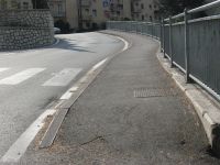
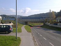
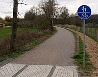
The tag is_sidepath=* is in use as a tag on ways, particularly cycle ways or footpaths, to indicate whether the path runs parallel to a street (roadside), making it adjoining, or runs separated and thus detached from the road (isolated).
During the creation of is_sidepath=* additional subtags were considered that can be used to explicitly tag important attributes of the adjoining road on the sidepath itself:
History: Those subtags were originally part of the original is_sidepath proposal but were extracted to keep that proposal focussed on the main tag.
This new proposal page is meant to be a place to discuss the use of those subtags and to get feedback from the community.
Rationale
The rationale of the original is_sidepath proposal applies.
In addition, the idea of the subtags is…
- …to give routing and data analysis processes easy access to additional information of the adjoining road.
- …to provide a reference between side path and street that can be used during data processing to improve map matching,
The tags can be used to…
| is_sidepath:of=* | …to improve routing by boosting roads by their road classification. |
| is_sidepath:of:name=* | …to improve routing by providing the name of the adjoining road ("Follow the cycle path along XY Road"). |
| is_sidepath:of:ref=* | …to improve map matching by data processing tools to identify the road by its reference code. |
Tagging
The aim of these subtags is to provide access to relational street attributes, specifically attributes that precisely define the type of street the path is located next to:
- is_sidepath:of=*: Indicates the road classification, such as primary or residential. This corresponds to the highway=* value assigned to the adjoining road.
- is_sidepath:of:name=*: Specifies the name=* of the adjoining road.
- is_sidepath:of:ref=*: Identifies the ref=* (reference number or code) of the adjoining road.
It is not advisable to include other road attributes, as these are either tagged directly on the separate way itself (e.g., surface=*, lit=*) or are less relevant for certain use cases (e.g., maxspeed=* on the road). It should be noted that adopting such attributes results in duplicating information, which contradicts the principle of avoiding data inconsistency in OSM. Since the adopted road attributes serve as indirect "pointers" and the three primary attributes mentioned above can offer significant benefits for applications while experiencing minimal changes over time, adopting them seems acceptable.
A road can have multiple sidepaths, with each sidepath attribute pointing to the same road as the "main roadway" (see examples below).
Examples
Typical examples for different types of ways and situations
All examples assume that the shown path is mapped separately.
Edge Cases: When it's a sidepath and when it's not?
Please refer to the original is_sidepath proposal.
Illustrations: How to use sidepath tagging at intersections?
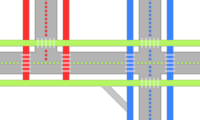
At intersections, sidepaths of different roads can converge. In such situations, it is not always clear to which road a sidepath belongs or whether a path is a sidepath or not. The following schematic illustrations demonstrate how sidepath tagging can be utilized and which reference attributes a sidepath should adopt in various situations. Different colors indicate the relationship between the highway centerlines and "their" sidepaths.
![]() Carriageway
Carriageway
![]() Crossing
Crossing
![]() Highway centerline
Highway centerline
![]() Sidepath tagged with relationship to a specific street (red, green, blue)
Sidepath tagged with relationship to a specific street (red, green, blue)
![]() Sidepath tagged without relationship to a specific street
Sidepath tagged without relationship to a specific street
![]() Other way (no sidepath)
Other way (no sidepath)
To keep the examples simple, we do not specify the type of way (e.g., sidewalk vs. path for bicycle and foot traffic). The examples above handle those cases and demonstrate when is_sidepath=yes is implicit for sidewalks.
|
At simple intersections, the sidepaths and crossing ways can each be related to a street. Ways linking between different sidewalks (light gray path at the bottom and middle) are usually not sidepaths. |
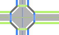
|
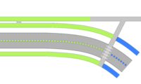
At large intersections, sidepaths of several streets sometimes merge. No clear relationship can be defined for the merged path segments. They are sidepaths (is_sidepath=yes), but cannot get a is_sidepath:of:name=* reference. However, use the classification of the "highest" adjoining street as the value for is_sidepath:of=*. |

|
Ways along roundabouts adopt the attributes of the roundabout. The sidepaths along the joining roads adopt the attributes of the joining roads. |
|
A way can change from a sidepath to a non-sidepath if it no longer continues along the road. If the name, class, or reference of an adjacent road changes, the adopted attributes of the sidepath also change. |
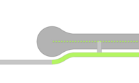
|
A way can change from a sidepath to a non-sidepath if the road ends but the way continues. Road links are not sidepaths. |
Current usage
By mappers
This tagging emerged in 2014 and was initially used by some individual mappers in Germany for some years. Since the beginning of 2021, this tagging has seen a strong increase (OSM Tag History) in use after it was mentioned on some community channels and wiki pages.
By applications
There are no known applications that use the subtagging yet. However, the main tag is_sidepath=* is used by some routing and data analysis tools (see original is_sidepath proposal.
Alternative concepts and it's limitations
Please refer to the original is_sidepath proposal.
Features/Pages affected
TODO: Not specified, yet.
External discussions
Please refer to the original is_sidepath proposal.
Comments
Please comment on the discussion page.


