RU:GPSMapEdit
| GPSMapEdit | ||||||||||||||||||||
|---|---|---|---|---|---|---|---|---|---|---|---|---|---|---|---|---|---|---|---|---|
| Автор: | Konstantin Galichsky | |||||||||||||||||||
| Лицензия: | proprietary shareware | |||||||||||||||||||
| Платформа: | Windows | |||||||||||||||||||
| Языки: | амхарский, немецкий, английский, испанский, персидский, финский, французский, итальянский, японский, польский, португальский, русский, шведский, турецкий, татарский, украинский, китайский, упрощенное письмо, и китайский, традиционное письмо
| |||||||||||||||||||
| Веб-сайт: | http://www.geopainting.com/ | |||||||||||||||||||
| Исходный код: | http://trac.openstreetmap.org/browser/applications/editors/django/osmeditor | |||||||||||||||||||
| Язык программирования: |
C++ | |||||||||||||||||||
| ||||||||||||||||||||
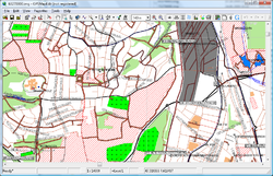
GPSMapEdit — популярный редактор карт в польском формате.
License
Это условно-бесплатная программа, работает под Windows или под Wine. It's a shareware program, running on various versions of Windows (using the native Win32 API) or under Wine. To display maps in the Garmin file format .img you don't need to buy the program. The source code (of version 1.0) is available for personal use, it cannot be used to publish derived versions without authorization from the author.
Features
This software is designed for visual authoring of maps, and allows inserting custom POIs and speedcams for: Garmin POI Loader, iGO, TomTom OV2, Navitel Navigator, CityGuide.
It supports various cartographic formats compatible with GPS/WGS84 coordinates: Polish format, Garmin MapSource/BaseCamp, Lowrance MapCreate, CityGuide (navigation software for Windows Mobile, Android, Symbian, iPhone), Navikey 7 Ways, Navitel Navigator 3.x, ALAN Map 500/600, Holux MapShow, Google Earth.
The program may also load and convert GPS-tracks, waypoints and routes in various formats: GPX, KML/KMZ, Garmin, iGO 8, iGO Primo, Lowrance, Magellan, Nokia, OziExplorer, ALAN, Holux.
Other supported file formats are: bitmap images (JPEG 2000, JPG, BMP, GIF, PNG, TIFF, EXIF), popular data files (CSV, XLS, DBF, MDB), and others (ECW, MrSID, KML/Google Maps, ESRI shapefile, MapInfo MIF/MID).
Смотри также
- Официальный сайт GpsMapEdit
- GPSMapEdit27_eng.zip — здесь тоже можно скачать эту программу.

