Tag:amenity=toilets
 |
| Description |
|---|
| Indicates publicly accessible toilets. |
| Rendering in OSM Carto |
| Group: amenities |
| Used on these elements |
| Useful combination |
|
| See also |
| Status: approved |
| Tools for this tag |
|
Use amenity=toilets to identify the location of a toilet open to the public. Public toilets are commonly referred to as restrooms, washrooms, bathrooms, or toiletrooms.
How to map
Place a node centrally at the location of the toilet amenities and tag it amenity=toilets. Alternatively draw an area over the toilet area and tag it with amenity=toilets, and if located in a dedicated building with building=toilets.
Tags used in combination
Following tags maybe useful to mark important properties:
- fee=yes/no - specify whether a fee is required.
- opening_hours=* - specify opening hours of the toilet. Toilets which are always available can be tagged with opening_hours=24/7.
- operator=* - name of entity responsible for toilet (e.g. "City of X").
- changing_table=yes/no/limited - availability of a nappy changing table.
- supervised=yes/no/interval - if the toilet is staffed. Note that a cleaner might expect a tip.
- toilets:number=* and toilets:num_chambers=* - the number of toilets (these tags were mainly added by imports in 2014 and 2017)
Toilet equipment
- toilets:paper_supplied=yes/no - Is wiping paper supplied? (Formerly
toilets=byop). - See toilets:hands_drying=* for tagging of various hand drying methods?
- toilets:handwashing=yes/no - Are hand washing facilities provided?
- handwashing:soap=yes/no - Is there soap (bar, liquid, foam, gel) for washing hands?
- handwashing:hand_disinfection=yes/no - Is there a dispenser with disinfectant (Alcohol in the gel)? You can find these in public places such as in a toilet, and at an entrance to a store.
- handwashing:hand_cleaning_paste=yes/no - Is there a dispenser with hand cleaning paste for washing hands covered with lubricants or oils?
- handwashing:creme=yes/no - Is there a dispenser with hand care cream?
- hot_water=yes/no - Is there hot water in the tap?
- toilets:menstrual_products=yes/limited/no - Are free menstrual products (e.g. tampons, pads) dispensed here? If a vending machine with these prodcuts is there, map the vending machine separately.
Disposal method
| Tag | Explanation | Example image |
|---|---|---|
| toilets:disposal=flush | toilets that move waste away from immediate area using a liquid (usually water). |
|
| toilets:disposal=pitlatrine | waste falls into a lined or unlined pit. If pitlatrine is composting composting=yes. | .jpg)
|
| toilets:disposal=chemical | waste falls into a lined pit filled with a chemical. |
|
| toilets:disposal=bucket | waste drops into a container which is periodically removed by hand. |
|
| toilets:disposal=dry_toilet | a device dehydrates waste into dry matter. |
|
| toilets:disposal=tank | a storage tank emptied by a pumping truck. Often used for portable toilets. | |
| toilets:disposal=incineration | A toilets that burns its contents to a sterile ash. |


.jpg)
.jpg)
Toilet seating
- toilets:position=seated/urinal/squat - specify sitting position, use a semicolon to separate multiple values.
Image Description Tag 
Only seated toilets toilets:position=seated 
Only urinal toilets toilets:position=urinal 
Only squat toilets toilets:position=squat 

Seated and urinal toilets; i.e., more than one type. toilets:position=seated;urinal (types listed separated by semicolons)


Tagging access to toilets
Public vs private access
Toilets can have complex access rules. Those rules useful to toilets include:
- access=yes - explicitly public and open to whoever walks up (a fee=* may still apply).
- access=customers - while open to the public, the clear policy is to require a purchase prior to use. You may need a key or code to get in. Some people also use access=destination, and a few use locked=* for this.
access=private,access=nouse room=toilets because amenity=toilets is for toilets "open to the public".- access=centralkey with centralkey=* if a toilet can be opened by a central key, that is distributed only to a limited group of persons (such as the
 Euro key).
Gender-based access
The male/female access details might be tagged simply for the overall amenity=toilets object:
- female=yes/no - whether women can use this toilet.
- male=yes/no - whether men can use this toilet.
- unisex=yes - unisex toilet.
- child=yes/no - children (seats and urinals for children).
Use gender_segregated=yes/no to unambiguously state whether a toilet is gender segregated or not.
It can be useful to map entrances or even areas of a toilet separately.
- entrance=yes would typically go on a node on each entrance
- female=yes/no, male=yes/no, unisex=yes/no tags go on the same entrance nodes or even on an area within a building.
Detail like this may be particularly useful for visually impaired users. Individual entrances/areas can also be individually mapped for wheelchair accessibility.

A unisex, gender neutral, toilet

A gender separated, non-unisex, toilet


Accessibility features
There are various types of accessibility types that can be found in and around toilets, almost all of them still need proper tagging.
Information for tagging wheelchair-accessibility can be found here.
Stoma-friendly toilets

Some toilets have a dedicated toilet for people with an ostomy system. According to the guidelines of the United Ostomy Association of America, the main requirements for such a toilet are having:
- hooks on the wall to hang equipment
- a shelf, to place supplies
- a sink with soap, to wash the skin area around the colostomy
- a mirror, to easily place the stoma back
- a waste basket
It is not the goal of OpenStreetMap to make a judgement on all toilets and to mark them as ostomy-friendly. This is a bit subjective (for example: some stoma-users don't require a mirror, whereas it is a must for others). However, mapping what features exist in a toilet can be done - refer to this page for more details. Ostomy-users can then filter out the toilets they need.
However, some toilets have explicit signage for ostomy users. If explicit signage is present, toilets:ostomy=yes can be applied. An example toilet with images can be found here
Toilets within places
Facilities such as shops and pubs often have toilets inside them for customers, and sometimes free for the public as part of a scheme (e.g. Richmond Council). On the usual tags of amenity=pub, building=yes, shop=* add the following tags and use the 'toilets' namespace.
- toilets=yes/no - refers to toilets accessible to the public
- toilets:access=* - refers to toilets accessible to a member of the public. Note that for example toilets:access=customers means that a toilet exists but is only available to customers.
All other tags described above can be used in this case, prefixed with toilets:=*
Avoid using toilet=* (singular).
In general don't map toilets that are inaccessible to the public. Many buildings have toilets inside for workers or owners, but mapping these could create needless conflict or unrealistic expectations. Use toilets=no for places you might expect to find a usable toilet (e.g. a railway station or trailhead) but no public toilets are made available.
Do not use toilets:access=* on toilets tagged as a separate object with amenity=toilets, use access=* instead.
See also
- drinking_water=yes/no - if a drinking water source is immediately associated with (usually outside) the toilet and/or the water in the sink is drinkable. Note: for micro mapping, it is better to create a separate node with amenity=drinking_water.
- shower=yes - Are shower facilities in the toilet. However, it might be better to add an extra node with amenity=shower
- building=toilets - An independent building built to house toilets.
- man_made=septic_tank - Use for a nearby septic tank e.g., under the soil in the garden. The toilet itself is likely a "flush" type.
Examples

A toilette hidden in an advertising column
Public toilets
Clearly marked separate toilets. On the front wall man_made=drinking_fountain

Mobile toilet - map only ones that are staying in a given place permanently
toilets:type=mobile(but 'type' is obsolete)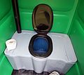
Inside a mobile toilet toilets:paper_supplied=yes/no
.jpg)
_02.jpg)

Maps using this tag
See the project listing on taginfo