Tag:building=quonset_hut
Jump to navigation
Jump to search
| Description |
|---|
| A lightweight prefabricated structure in the shape of a semicylinder. |
| Rendering in OSM Carto |

|
| Group: buildings |
| Used on these elements |
| Useful combination |
| See also |
| Status: proposed |
| Tools for this tag |
|
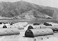
A ![]() quonset hut is a lightweight prefabricated structure in the shape of a semicylinder.
quonset hut is a lightweight prefabricated structure in the shape of a semicylinder.
It is often on military bases, farms, and used as airplane hangers.
It is commonly made out of steel sheet metal and contains entrances at the front and back.
Tagging
If used on an airplane hanger, add aeroway=hangar instead of mapping it as building=hangar.
