Tag:canoe=portage
| Description |
|---|
| Portage of light watercraft between two bodies of water |
| Group: restrictions |
| Used on these elements |
| Status: de facto |
| Tools for this tag |
|
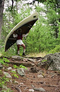
A ![]() Portage is a location at which boats can be transported between two bodies of water if no connection along the waterways is possible. This is the case, for example, at weirs, locks, unnavigable rapids or different water systems separated by land. Aids may be provided for this purpose, for example piers or sheeting to facilitate getting in and out of the canoe and cleared paths or tracks to walk on.
Portage is a location at which boats can be transported between two bodies of water if no connection along the waterways is possible. This is the case, for example, at weirs, locks, unnavigable rapids or different water systems separated by land. Aids may be provided for this purpose, for example piers or sheeting to facilitate getting in and out of the canoe and cleared paths or tracks to walk on.
In rare cases additional facilities such as a boat trolley on which the boat can be transported by means of a rope hoist are present. They can be manually or electrically operated. Another example is a pulley system.
How to map
Set a way along the portage connecting it at each end to the two waterbodies and waterway=*. Add the tag canoe=portage to highway=* where applicable.
When joining a highway=* to waterway=* for a portage, add canoe=portage to the node where they join, so it is clear that this is not a mapping mistake (as some validators might assume), but a point where land based transport becomes water based transport and vice versa
If a man_made=pier is part of a portage, add canoe=portage to it.
For a waterway=* that is not navigable, but that can circumvented by carrying the canoe over land, add canoe=portage to indicate this — do not tag the waterway=* leading up the portage detour with this tag though!
For signposted portage routes a relation can be used
For boat trolleys and pulley systems Connect the end of the portage (the rails or pulley system) to the waterbodies' center line with the tag waterway=portage to add the possiblity of routing along this connection.
Current usage
canoe=portage on ways (august 2021, appoximately 800 ways)
- 75% is used on a highway=*, to indicate that this way is used to carry a canoe over land
- 20% is used on a man_made=pier for piers that are part of a portage
- 5% is used on a waterway=* to indicate that this waterway is not navigable and must be cirmumvented
Examples
- Pier made for the portage between two lakes on a signposted portage route
- Punt rollers at Oxford (Parson's Pleasure) and Cambridge (Mill Pond, Newnham).
Routing and Rendering
https://brouter.de/brouter-web/ allows users to make custom routing profiles that also work for routing over both waterways and highways used in a portage as long these are connected with a shared node (just like normal routing over highways). Based on the assigned cost factors routing options with either a longer distance over water or options with portages can be preferred in situations where there are multiple options.
https://OpenStreetBrowser.org/ renders routes. Enable the category: Leisure, Sport and Shopping > Outdoor activities > Paddling > Paddling Routes. Add Paddling Amenities and Paddling Hazards for a complete picture.
OsmAnd can be used for measuring and routing waterways. At this time, it does not support canoe routes. GitHub issue 16105 asks that support be added.
See also
waterway=portage — Tag used for a way routing between the centerline of the waterbody and the physical portage.
Portages used by whitewater sport participants are more usually tagged whitewater=portage_way, whitewater=portage or portage=yes, along with highway=footway or highway=path. In practice these are like footpaths with enough width & headroom to allow kayaks and canoes to be carried without snagging on vegetation. Ship or Boat lifts used to move craft between two levels in a waterway system in general should be mapped with the appropriate tag. Boat lifts in marinas used to lift yachts in and out of the water should also be tagged distinctly.


