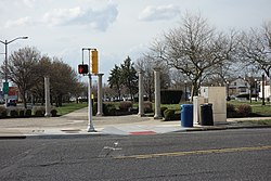
Tag:crossing=unmarked
| Description |
|---|
| Pedestrian crossings without road markings or traffic signals. |
| Group: crossings |
| Used on these elements |
| Implies |
| Useful combination |
| Status: approved |
| Tools for this tag |
|
This tag is used for pedestrian crossings without zebra crossing or traffic signals. By a structural measure the transition should be recognizable.
In areas where sidewalks are mapped as separate geometries, it is commonly seen that every node at which a sidewalk crosses a road, an unmarked crossing is added. So this is something to look out for as data consumer, crossings tagged like this often do not have any recognizable structural measure that deserve to be called a dedicated crossing.
How to map
Set a node ![]() on the highway where the transition is and add highway=crossing + crossing=unmarked.
on the highway where the transition is and add highway=crossing + crossing=unmarked.
If the crossing is also mapped as a ![]() way, tag it as highway=footway footway=crossing crossing=unmarked or highway=cycleway cycleway=crossing crossing=unmarked as appropriate.
way, tag it as highway=footway footway=crossing crossing=unmarked or highway=cycleway cycleway=crossing crossing=unmarked as appropriate.
crossing=unmarked implies crossing:markings=no. Adding crossing:markings=no is possible, but not necessary. Any crossing=unmarked with crossing:markings=* present and set to a value other than no could point to a mistake in the tagging.
Map examples
Tags used in combination
- tactile_paving=yes/no to indicate whether it's made easier to cross for blind people
- kerb=* or also wheelchair=* to indicate whether people in wheelchairs can easily cross
- crossing:island=yes/no to indicate whether there is a crossing island in the middle
- traffic_calming=* to indicate if additionally a kind of traffic calming is built into the crossing. Especially common in this combination are traffic_calming=chokers and traffic_calming=tables
Tricky cases
Crossing with traffic signs and traffic_calming=table, without zebra crossing or traffic signals. Example
 Example
Regional considerations
United States
Many localities have laws against jaywalking, making it especially important to map a crossing at any point that is designated for crossing the street, not just where there is extensive physical infrastructure for a pedestrian crossing.
Some states have laws that establish an implied crossing on every side of every intersection by default[1] or wherever one is implied by a sidewalk flanking the intersection,[2] unless otherwise prohibited by a regulatory sign. This can technically result in very unsafe crossings that most people would not recognize as crossings, such as across a busy four-lane road without any pedestrian infrastructure. It would be reasonable to omit such crossings in favor of safer ones.
In some areas, it is common for a crosswalk to have pedestrian signals but lack road markings. There was a proposal to tag such crosswalks as highway=crossing crossing=unmarked crossing:signals=yes, but highway=crossing crossing:markings=no crossing:signals=yes has more recently become possible. A crosswalk at a signalized intersection could have neither markings nor pedestrian signals, requiring pedestrians to observe the same traffic lights as cars going in the same direction.[3][4][5] This proposal would introduce crossing:signals=shared for this situation, which is common in some places.
Unmarked crossings are increasingly easy to identify by curb cuts and curb ramps, which are required for compliance with the Americans with Disabilities Act of 1990.
Software support
Renderers
OSM2World avoids applying a white dash along both sides of the crossing way. [1]
osm2streets (see AB Street) draws transverse white lines, as opposed to parallel white bars that denote crossing=marked.
Routers
OsmAnd penalizes the crossing by more time than crossing=uncontrolled but less time than crossing=traffic_signals. [2]
GraphHopper infers crossing:markings=no crossing:signals=no from crossing=unmarked. [3]
See also
- crossing=* - for an overview of crossing tagging
- crossing=informal - informal crossing
- crossing=marked - for a generic marked crossing regardless of specific markings
- crossing_ref=zebra - an additional qualifier to record only the marking type.
References
- ↑ California Vehicle Code, section 275.
- ↑ Revised Statutes of Missouri, section 300.010.
- ↑ Ohio Revised Code, section 4511.13.
- ↑ Texas Transportation Code, chapter 552.
- ↑ “Manual on Uniform Traffic Control Devices”. Washington, D.C.: Federal Highway Administration. May 2012. Section 4D.04.


